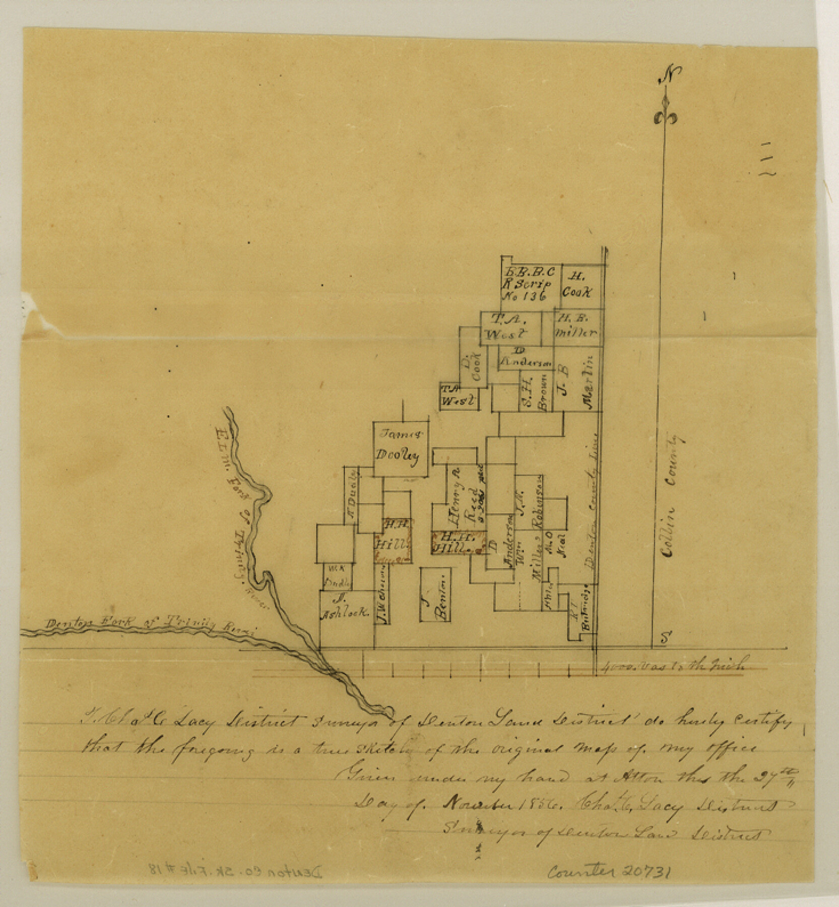
Denton County Sketch File 18
[Sketch of surveys in southeast corner of the county just east of the Trinity River]
-
Map/Doc
20731
-
Collection
General Map Collection
-
Object Dates
1856/11/26 (Creation Date)
1857/5/28 (File Date)
-
People and Organizations
Chas. C. Lacy (Surveyor/Engineer)
-
Counties
Denton
-
Subjects
Surveying Sketch File
-
Height x Width
7.9 x 7.3 inches
20.1 x 18.5 cm
-
Medium
paper, manuscript
-
Scale
1:4000
-
Features
Elm Fork of Trinity River
Denton Fork of Trinity River
Part of: General Map Collection
Flight Mission No. DCL-6C, Frame 17, Kenedy County

Print $20.00
- Digital $50.00
Flight Mission No. DCL-6C, Frame 17, Kenedy County
1943
Size 18.6 x 22.4 inches
Map/Doc 85874
Kendall County Boundary File 2

Print $4.00
- Digital $50.00
Kendall County Boundary File 2
Size 10.2 x 8.2 inches
Map/Doc 55746
Southern Pacific Transportation Company, Right of Way and Track Map, Beeville Branch

Print $40.00
- Digital $50.00
Southern Pacific Transportation Company, Right of Way and Track Map, Beeville Branch
Size 24.1 x 56.1 inches
Map/Doc 76163
Swisher County Rolled Sketch 6

Print $20.00
- Digital $50.00
Swisher County Rolled Sketch 6
1941
Size 43.0 x 27.6 inches
Map/Doc 7907
Zapata County Working Sketch 6

Print $40.00
- Digital $50.00
Zapata County Working Sketch 6
1946
Size 65.9 x 37.0 inches
Map/Doc 62057
Fisher County Sketch File 18

Print $12.00
- Digital $50.00
Fisher County Sketch File 18
1901
Size 8.2 x 5.5 inches
Map/Doc 22589
Goliad County Working Sketch 14

Print $20.00
- Digital $50.00
Goliad County Working Sketch 14
1946
Size 29.5 x 42.8 inches
Map/Doc 63204
Uvalde County Sketch File 19

Print $4.00
- Digital $50.00
Uvalde County Sketch File 19
1882
Size 10.6 x 8.6 inches
Map/Doc 39000
Flight Mission No. DAG-23K, Frame 183, Matagorda County

Print $20.00
- Digital $50.00
Flight Mission No. DAG-23K, Frame 183, Matagorda County
1953
Size 18.5 x 22.3 inches
Map/Doc 86518
Flight Mission No. CGI-4N, Frame 163, Cameron County

Print $20.00
- Digital $50.00
Flight Mission No. CGI-4N, Frame 163, Cameron County
1955
Size 18.6 x 22.3 inches
Map/Doc 84671
Orange County Sketch File 38

Print $6.00
- Digital $50.00
Orange County Sketch File 38
1954
Size 14.3 x 8.7 inches
Map/Doc 33378
Kinney County Rolled Sketch 6

Print $20.00
- Digital $50.00
Kinney County Rolled Sketch 6
Size 27.1 x 36.8 inches
Map/Doc 6536
You may also like
Corpus Christi Pass
Print $20.00
- Digital $50.00
Corpus Christi Pass
1880
Size 45.5 x 41.0 inches
Map/Doc 2694
Parker County Sketch File 42

Print $114.00
- Digital $50.00
Parker County Sketch File 42
1877
Size 14.4 x 12.0 inches
Map/Doc 33589
Palo Pinto County Sketch File 22

Print $20.00
- Digital $50.00
Palo Pinto County Sketch File 22
1939
Size 19.6 x 15.0 inches
Map/Doc 12134
Bosque County Working Sketch 29

Print $20.00
- Digital $50.00
Bosque County Working Sketch 29
2009
Size 35.9 x 40.6 inches
Map/Doc 88997
Cochran County Working Sketch 1
Print $20.00
- Digital $50.00
Cochran County Working Sketch 1
1940
Size 21.1 x 35.9 inches
Map/Doc 68012
Flight Mission No. BRA-16M, Frame 65, Jefferson County

Print $20.00
- Digital $50.00
Flight Mission No. BRA-16M, Frame 65, Jefferson County
1953
Size 18.7 x 22.4 inches
Map/Doc 85682
Map of Tyler County

Print $20.00
- Digital $50.00
Map of Tyler County
1897
Size 42.0 x 37.5 inches
Map/Doc 16907
Tyler County Sketch File 6-3

Print $20.00
- Digital $50.00
Tyler County Sketch File 6-3
1861
Size 20.0 x 22.1 inches
Map/Doc 12499
General Highway Map, Swisher County, Texas

Print $20.00
General Highway Map, Swisher County, Texas
1940
Size 18.4 x 25.0 inches
Map/Doc 79250
Mills County Working Sketch 18

Print $20.00
- Digital $50.00
Mills County Working Sketch 18
1963
Size 23.2 x 37.0 inches
Map/Doc 71048
Flight Mission No. CRK-3P, Frame 63, Refugio County

Print $20.00
- Digital $50.00
Flight Mission No. CRK-3P, Frame 63, Refugio County
1956
Size 18.5 x 22.4 inches
Map/Doc 86905
Schleicher County Sketch File 27

Print $20.00
- Digital $50.00
Schleicher County Sketch File 27
Size 23.0 x 19.2 inches
Map/Doc 12305