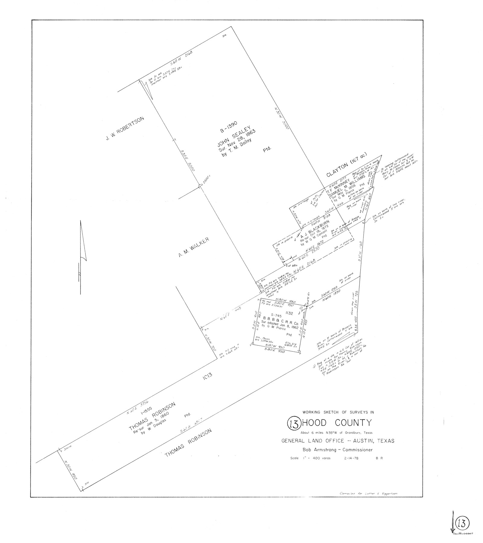
Hood County Working Sketch 13
-
Map/Doc
66207
-
Collection
General Map Collection
-
Object Dates
2/14/1978 (Creation Date)
-
People and Organizations
Beverly Robison (Draftsman)
-
Counties
Hood
-
Subjects
Surveying Working Sketch
-
Height x Width
27.6 x 24.5 inches
70.1 x 62.2 cm
-
Scale
1" = 400 varas
Part of: General Map Collection
San Patricio County Aerial Photograph Index Sheet 3

Print $20.00
- Digital $50.00
San Patricio County Aerial Photograph Index Sheet 3
1957
Size 19.1 x 24.0 inches
Map/Doc 83745
Jefferson County Rolled Sketch 46

Print $3.00
- Digital $50.00
Jefferson County Rolled Sketch 46
Size 15.7 x 10.0 inches
Map/Doc 9304
Denton County Working Sketch 3

Print $20.00
- Digital $50.00
Denton County Working Sketch 3
1935
Size 24.6 x 36.4 inches
Map/Doc 68608

Flight Mission No. BRA-3M, Frame 198, Jefferson County

Print $20.00
- Digital $50.00
Flight Mission No. BRA-3M, Frame 198, Jefferson County
1953
Size 18.7 x 22.4 inches
Map/Doc 85413
Liberty County Rolled Sketch JP2

Print $40.00
- Digital $50.00
Liberty County Rolled Sketch JP2
1935
Size 52.0 x 12.5 inches
Map/Doc 9568
Cameron County Rolled Sketch 25

Print $20.00
- Digital $50.00
Cameron County Rolled Sketch 25
1977
Size 24.6 x 36.7 inches
Map/Doc 5796
Motley County Sketch File 3 (N)

Print $22.00
- Digital $50.00
Motley County Sketch File 3 (N)
Size 9.1 x 13.0 inches
Map/Doc 31998
University Lands Block 35 Crane & Ector Counties

Print $20.00
- Digital $50.00
University Lands Block 35 Crane & Ector Counties
1935
Size 40.2 x 46.7 inches
Map/Doc 2442
Gaines County Working Sketch 7

Print $20.00
- Digital $50.00
Gaines County Working Sketch 7
1940
Size 16.5 x 38.5 inches
Map/Doc 69307
Carson County Sketch File 6c

Print $20.00
- Digital $50.00
Carson County Sketch File 6c
Size 26.6 x 15.5 inches
Map/Doc 11055
Controlled Mosaic by Jack Amman Photogrammetric Engineers, Inc - Sheet 57

Print $20.00
- Digital $50.00
Controlled Mosaic by Jack Amman Photogrammetric Engineers, Inc - Sheet 57
1954
Size 20.0 x 24.0 inches
Map/Doc 83516
You may also like
Presidio County Working Sketch 29

Print $20.00
- Digital $50.00
Presidio County Working Sketch 29
1946
Size 40.0 x 36.6 inches
Map/Doc 71705
[Surveys along the Sabine River made under G.W. Smyth, Commissioner]
![90, [Surveys along the Sabine River made under G.W. Smyth, Commissioner], General Map Collection](https://historictexasmaps.com/wmedia_w700/maps/90.tif.jpg)
Print $20.00
- Digital $50.00
[Surveys along the Sabine River made under G.W. Smyth, Commissioner]
1837
Size 13.9 x 17.0 inches
Map/Doc 90
Cherokee County Sketch File 18

Print $4.00
- Digital $50.00
Cherokee County Sketch File 18
1870
Size 10.2 x 8.1 inches
Map/Doc 18159
Bastrop County Rolled Sketch 6

Print $20.00
- Digital $50.00
Bastrop County Rolled Sketch 6
2013
Size 42.3 x 32.1 inches
Map/Doc 93716
Bandera County Working Sketch 19

Print $20.00
- Digital $50.00
Bandera County Working Sketch 19
1946
Size 43.3 x 35.8 inches
Map/Doc 67615
General Highway Map. Detail of Cities and Towns in Bexar County, Texas. City Map of San Antonio, Alamo Heights, Olmos Park, Terrell Hills, Castle Hills, Balcones Heights, and vicinity, Bexar County, Texas

Print $20.00
General Highway Map. Detail of Cities and Towns in Bexar County, Texas. City Map of San Antonio, Alamo Heights, Olmos Park, Terrell Hills, Castle Hills, Balcones Heights, and vicinity, Bexar County, Texas
1961
Size 18.1 x 25.1 inches
Map/Doc 79373
Galveston Bay

Print $20.00
- Digital $50.00
Galveston Bay
1907
Size 40.6 x 34.4 inches
Map/Doc 69871
Map of a part of Laguna Madre showing subdivision for mineral development

Print $20.00
- Digital $50.00
Map of a part of Laguna Madre showing subdivision for mineral development
1948
Size 42.9 x 31.0 inches
Map/Doc 2913
Hopkins County Sketch File 11

Print $4.00
- Digital $50.00
Hopkins County Sketch File 11
Size 7.7 x 7.7 inches
Map/Doc 26704
Outer Continental Shelf Leasing Maps (Louisiana Offshore Operations)

Print $20.00
- Digital $50.00
Outer Continental Shelf Leasing Maps (Louisiana Offshore Operations)
1959
Size 17.7 x 13.9 inches
Map/Doc 76114
Upshur County Sketch File 13

Print $4.00
- Digital $50.00
Upshur County Sketch File 13
1861
Size 8.2 x 8.3 inches
Map/Doc 38755
Flight Mission No. CRC-3R, Frame 91, Chambers County

Print $20.00
- Digital $50.00
Flight Mission No. CRC-3R, Frame 91, Chambers County
1956
Size 18.7 x 22.4 inches
Map/Doc 84829