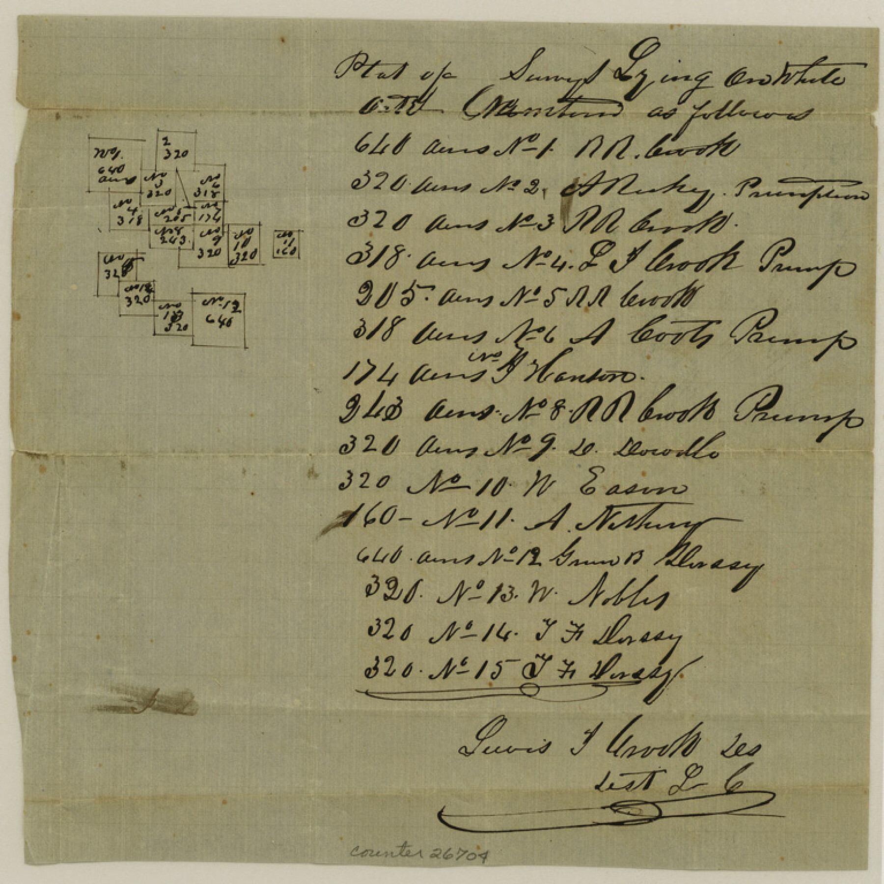
Hopkins County Sketch File 11
[Sketch northwest of Sulphur Springs]
-
Map/Doc
26704
-
Collection
General Map Collection
-
Object Dates
1/19/1858 (File Date)
-
People and Organizations
Lewis T. Crook (Surveyor/Engineer)
-
Counties
Hopkins
-
Subjects
Surveying Sketch File
-
Height x Width
7.7 x 7.7 inches
19.6 x 19.6 cm
-
Medium
paper, manuscript
Part of: General Map Collection
Houston County Sketch File 12

Print $4.00
- Digital $50.00
Houston County Sketch File 12
1849
Size 8.2 x 14.7 inches
Map/Doc 26773
Rusk County Working Sketch 20a

Print $20.00
- Digital $50.00
Rusk County Working Sketch 20a
Size 17.8 x 21.3 inches
Map/Doc 63655
DeWitt County Boundary File 1

Print $74.00
- Digital $50.00
DeWitt County Boundary File 1
Size 23.4 x 14.9 inches
Map/Doc 52479
Crockett County Rolled Sketch P1

Print $82.00
- Digital $50.00
Crockett County Rolled Sketch P1
1927
Size 10.3 x 15.9 inches
Map/Doc 44220
Flight Mission No. BRE-2P, Frame 21, Nueces County

Print $20.00
- Digital $50.00
Flight Mission No. BRE-2P, Frame 21, Nueces County
1956
Size 18.5 x 22.3 inches
Map/Doc 86730
Guadalupe County Sketch File 7c

Print $22.00
- Digital $50.00
Guadalupe County Sketch File 7c
Size 12.7 x 15.5 inches
Map/Doc 24672
Wheeler County Sketch File 3

Print $24.00
- Digital $50.00
Wheeler County Sketch File 3
1881
Size 12.9 x 8.4 inches
Map/Doc 39998
Freestone County Sketch File 14

Print $4.00
- Digital $50.00
Freestone County Sketch File 14
1861
Size 13.0 x 8.2 inches
Map/Doc 23065
Texas, Corpus Christi Bay, Nueces Bay

Print $40.00
- Digital $50.00
Texas, Corpus Christi Bay, Nueces Bay
1934
Size 34.0 x 48.9 inches
Map/Doc 73458
Wichita County Boundary File 2b

Print $4.00
- Digital $50.00
Wichita County Boundary File 2b
Size 8.9 x 8.8 inches
Map/Doc 59911
Webb County Working Sketch 58

Print $20.00
- Digital $50.00
Webb County Working Sketch 58
1958
Size 37.4 x 37.0 inches
Map/Doc 72424
Boundary Between the United States & Mexico Agreed upon by the Joint Commission under the Treaty of Guadalupe Hidalgo

Print $4.00
- Digital $50.00
Boundary Between the United States & Mexico Agreed upon by the Joint Commission under the Treaty of Guadalupe Hidalgo
1853
Size 18.3 x 26.8 inches
Map/Doc 72881
You may also like
Flight Mission No. CGI-1N, Frame 166, Cameron County

Print $20.00
- Digital $50.00
Flight Mission No. CGI-1N, Frame 166, Cameron County
1955
Size 18.5 x 22.2 inches
Map/Doc 84501
Orange County Sketch File 44

Print $4.00
- Digital $50.00
Orange County Sketch File 44
1895
Size 10.9 x 8.8 inches
Map/Doc 33387
La Salle County Working Sketch 30

Print $20.00
- Digital $50.00
La Salle County Working Sketch 30
1955
Size 34.6 x 28.9 inches
Map/Doc 70331
Upton County Working Sketch 10

Print $20.00
- Digital $50.00
Upton County Working Sketch 10
1926
Size 28.1 x 30.6 inches
Map/Doc 69506
Louisiana and Texas Intracoastal Waterway

Print $20.00
- Digital $50.00
Louisiana and Texas Intracoastal Waterway
1929
Size 13.8 x 19.7 inches
Map/Doc 83340
Pecos County Sketch File 28a

Print $14.00
- Digital $50.00
Pecos County Sketch File 28a
1911
Size 14.5 x 8.9 inches
Map/Doc 33683
[I. & G. N. RR. Co. Blk. 6, Blks M8, M9 and M10]
![90267, [I. & G. N. RR. Co. Blk. 6, Blks M8, M9 and M10], Twichell Survey Records](https://historictexasmaps.com/wmedia_w700/maps/90267-1.tif.jpg)
Print $20.00
- Digital $50.00
[I. & G. N. RR. Co. Blk. 6, Blks M8, M9 and M10]
Size 34.2 x 20.3 inches
Map/Doc 90267
Rhyne Simpson Quirt Ave. Addition to the City of Lubbock

Print $20.00
- Digital $50.00
Rhyne Simpson Quirt Ave. Addition to the City of Lubbock
1951
Size 17.2 x 21.2 inches
Map/Doc 92878
Tom Green County Sketch File 63

Print $20.00
- Digital $50.00
Tom Green County Sketch File 63
1890
Size 31.8 x 17.9 inches
Map/Doc 12445
Terrell County Working Sketch 6

Print $20.00
- Digital $50.00
Terrell County Working Sketch 6
1914
Size 15.7 x 21.9 inches
Map/Doc 62155
Map of Texas Before Admission to the Union and Adjoining State with Northern Portions of the Mexican States of Coahulia & Chihuahua

Print $20.00
- Digital $50.00
Map of Texas Before Admission to the Union and Adjoining State with Northern Portions of the Mexican States of Coahulia & Chihuahua
1834
Size 18.8 x 21.2 inches
Map/Doc 2107
[Sketch Between Wheeler County and Oklahoma]
![89665, [Sketch Between Wheeler County and Oklahoma], Twichell Survey Records](https://historictexasmaps.com/wmedia_w700/maps/89665-1.tif.jpg)
Print $40.00
- Digital $50.00
[Sketch Between Wheeler County and Oklahoma]
Size 8.8 x 62.7 inches
Map/Doc 89665