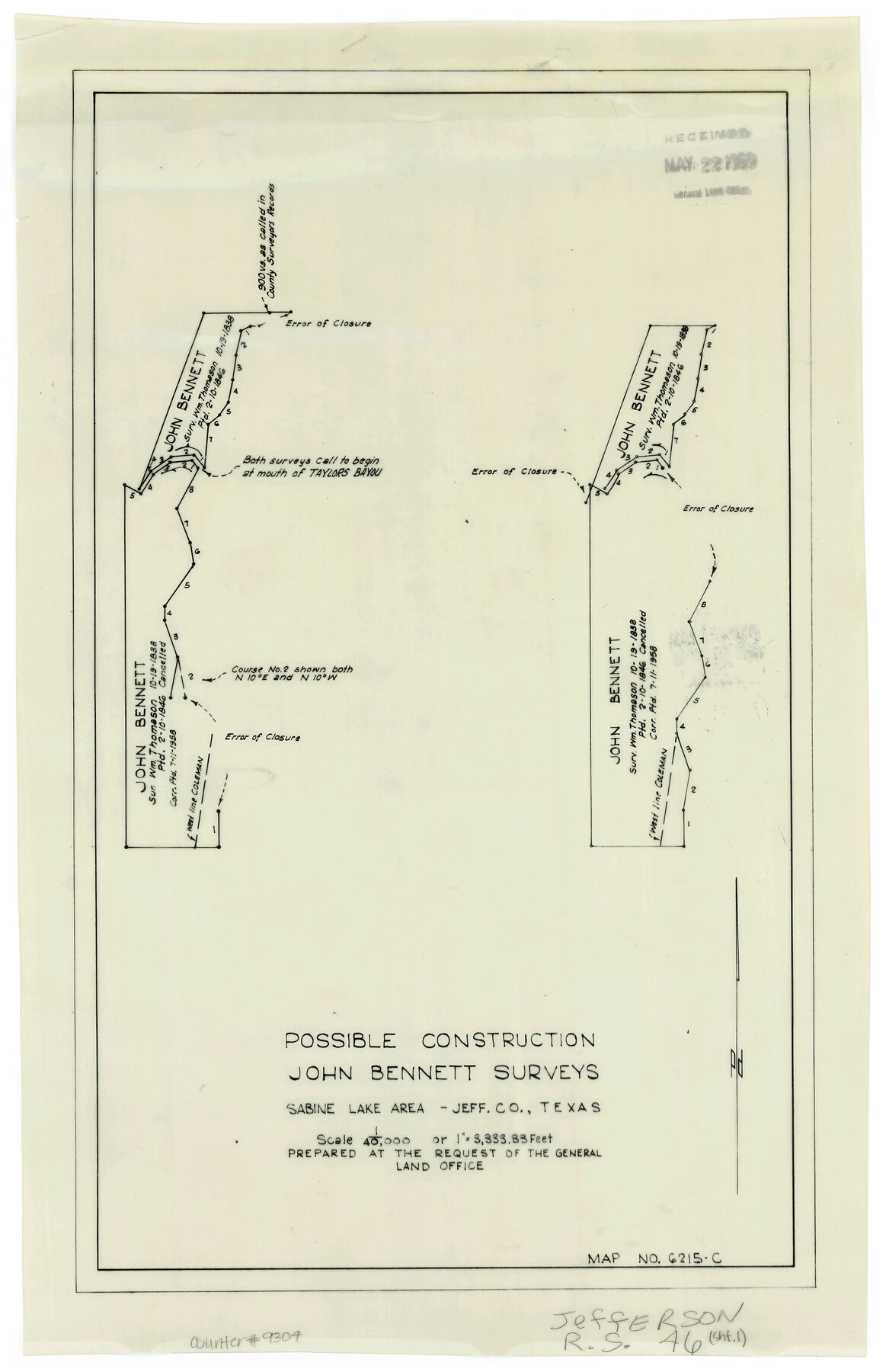
Jefferson County Rolled Sketch 46
Possible construction, John Bennett surveys - Sabine Lake area
-
Map/Doc
9304
-
Collection
General Map Collection
-
Counties
Jefferson
-
Subjects
Surveying Rolled Sketch
-
Height x Width
15.7 x 10.0 inches
39.9 x 25.4 cm
-
Medium
paper, manuscript
Part of: General Map Collection
Fannin County

Print $20.00
- Digital $50.00
Fannin County
1946
Size 42.3 x 37.4 inches
Map/Doc 73145
Wharton County Sketch File 11

Print $4.00
- Digital $50.00
Wharton County Sketch File 11
1891
Size 9.1 x 12.3 inches
Map/Doc 39933
[Neches River Bed, Plat and Calculations]
![77100, [Neches River Bed, Plat and Calculations], General Map Collection](https://historictexasmaps.com/wmedia_w700/maps/77100.tif.jpg)
Print $20.00
- Digital $50.00
[Neches River Bed, Plat and Calculations]
1928
Size 25.6 x 37.2 inches
Map/Doc 77100
[Sketch for Mineral Application 27670 - Strip between Simon Sanchez leagues and Trinity River]
![65645, [Sketch for Mineral Application 27670 - Strip between Simon Sanchez leagues and Trinity River], General Map Collection](https://historictexasmaps.com/wmedia_w700/maps/65645.tif.jpg)
Print $40.00
- Digital $50.00
[Sketch for Mineral Application 27670 - Strip between Simon Sanchez leagues and Trinity River]
Size 17.5 x 55.2 inches
Map/Doc 65645
[Capitol Lands in Dallam, Hartley, Oldham, Deaf Smith, Parmer, Bailey, Lamb, Cochran, Castro, and Hockley Counties]
![60295, [Capitol Lands in Dallam, Hartley, Oldham, Deaf Smith, Parmer, Bailey, Lamb, Cochran, Castro, and Hockley Counties], General Map Collection](https://historictexasmaps.com/wmedia_w700/maps/60295.tif.jpg)
Print $40.00
- Digital $50.00
[Capitol Lands in Dallam, Hartley, Oldham, Deaf Smith, Parmer, Bailey, Lamb, Cochran, Castro, and Hockley Counties]
Size 55.4 x 22.0 inches
Map/Doc 60295
Crockett County Sketch File 65

Print $20.00
- Digital $50.00
Crockett County Sketch File 65
1927
Size 23.2 x 36.6 inches
Map/Doc 11230
Pecos County Sketch File 38

Print $4.00
- Digital $50.00
Pecos County Sketch File 38
1895
Size 11.3 x 8.8 inches
Map/Doc 33720
Wood County Working Sketch 13

Print $20.00
- Digital $50.00
Wood County Working Sketch 13
1973
Size 23.1 x 20.2 inches
Map/Doc 62013
Newton County Rolled Sketch 6A

Digital $50.00
Newton County Rolled Sketch 6A
Size 10.3 x 15.4 inches
Map/Doc 46838
Flight Mission No. DIX-7P, Frame 85, Aransas County

Print $20.00
- Digital $50.00
Flight Mission No. DIX-7P, Frame 85, Aransas County
1956
Size 18.7 x 22.4 inches
Map/Doc 83879
San Jacinto County Rolled Sketch 14

Print $20.00
- Digital $50.00
San Jacinto County Rolled Sketch 14
1998
Size 25.8 x 37.2 inches
Map/Doc 7569
Bowie County Sketch File 6

Print $10.00
- Digital $50.00
Bowie County Sketch File 6
1927
Size 8.5 x 4.0 inches
Map/Doc 14839
You may also like
University Land Field Notes for Blocks 1, 2, 8, 9, and 10 in Reagan County, Blocks 6 and 7 in Crockett and Reagan Counties, Blocks 3, 4, and 58 in Reagan and Upton Counties, and Block 5 in Crockett, Reagan, and Upton Counties

University Land Field Notes for Blocks 1, 2, 8, 9, and 10 in Reagan County, Blocks 6 and 7 in Crockett and Reagan Counties, Blocks 3, 4, and 58 in Reagan and Upton Counties, and Block 5 in Crockett, Reagan, and Upton Counties
Map/Doc 81716
Anderson County Sketch File 12

Print $6.00
- Digital $50.00
Anderson County Sketch File 12
1852
Size 13.7 x 8.3 inches
Map/Doc 12771
Western Territories of the United States

Print $20.00
- Digital $50.00
Western Territories of the United States
1847
Size 12.1 x 19.0 inches
Map/Doc 93543
Right of Way and Track Map, the Missouri, Kansas and Texas Ry. of Texas - Henrietta Division

Print $20.00
- Digital $50.00
Right of Way and Track Map, the Missouri, Kansas and Texas Ry. of Texas - Henrietta Division
1918
Size 11.7 x 26.8 inches
Map/Doc 64767
Flight Mission No. BRE-2P, Frame 6, Nueces County

Print $20.00
- Digital $50.00
Flight Mission No. BRE-2P, Frame 6, Nueces County
1956
Size 18.6 x 22.6 inches
Map/Doc 86715
Flight Mission No. CGI-4N, Frame 189, Cameron County

Print $20.00
- Digital $50.00
Flight Mission No. CGI-4N, Frame 189, Cameron County
1955
Size 18.5 x 22.2 inches
Map/Doc 84692
Flight Mission No. DCL-7C, Frame 144, Kenedy County

Print $20.00
- Digital $50.00
Flight Mission No. DCL-7C, Frame 144, Kenedy County
1943
Size 18.6 x 22.5 inches
Map/Doc 86101
Erath County Sketch File 26

Print $6.00
- Digital $50.00
Erath County Sketch File 26
1896
Size 9.5 x 8.1 inches
Map/Doc 22306
Mason County Rolled Sketch 7

Print $20.00
- Digital $50.00
Mason County Rolled Sketch 7
1986
Size 24.3 x 20.3 inches
Map/Doc 6679
Flight Mission No. DAG-23K, Frame 174, Matagorda County

Print $20.00
- Digital $50.00
Flight Mission No. DAG-23K, Frame 174, Matagorda County
1953
Size 18.5 x 22.3 inches
Map/Doc 86512
Robertson Co.

Print $40.00
- Digital $50.00
Robertson Co.
1945
Size 48.5 x 39.3 inches
Map/Doc 73276
[Block XR, Capitol Leagues 161, 162, 164, 174, 178, 179, and 180]
![90661, [Block XR, Capitol Leagues 161, 162, 164, 174, 178, 179, and 180], Twichell Survey Records](https://historictexasmaps.com/wmedia_w700/maps/90661-1.tif.jpg)
Print $20.00
- Digital $50.00
[Block XR, Capitol Leagues 161, 162, 164, 174, 178, 179, and 180]
1908
Size 12.3 x 21.1 inches
Map/Doc 90661