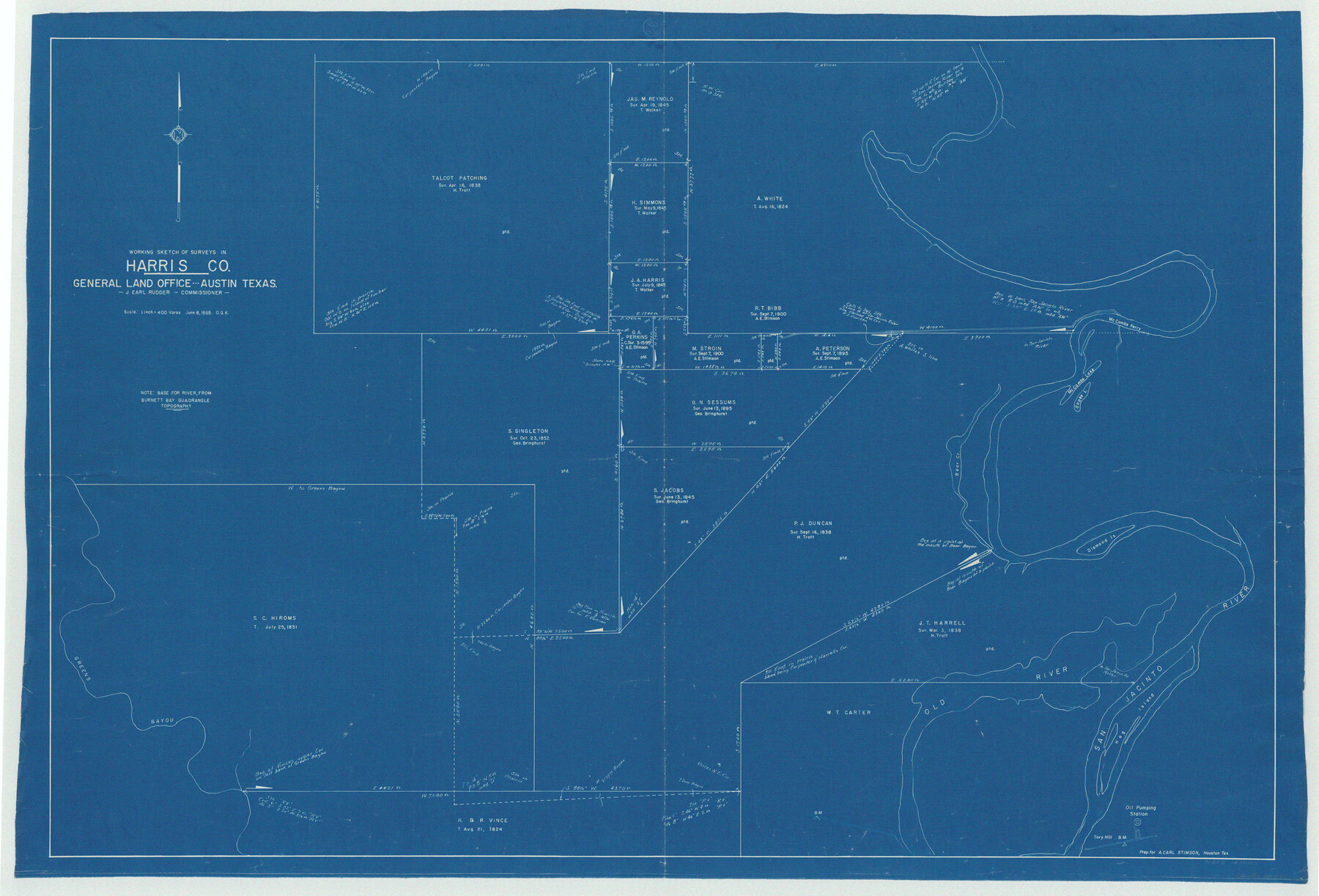
Harris County Working Sketch 66
-
Map/Doc
65958
-
Collection
General Map Collection
-
Object Dates
6/8/1955 (Creation Date)
-
People and Organizations
Otto G. Kurio (Draftsman)
-
Counties
Harris
-
Subjects
Surveying Working Sketch
-
Height x Width
33.7 x 49.7 inches
85.6 x 126.2 cm
-
Scale
1" = 400 varas
Part of: General Map Collection
Fisher County

Print $20.00
- Digital $50.00
Fisher County
1921
Size 45.8 x 40.4 inches
Map/Doc 66822
Brewster County Rolled Sketch 63

Print $40.00
- Digital $50.00
Brewster County Rolled Sketch 63
1939
Size 77.1 x 43.6 inches
Map/Doc 8488
Upton County Sketch File 30

Print $5.00
- Digital $50.00
Upton County Sketch File 30
1887
Size 21.0 x 31.6 inches
Map/Doc 12522
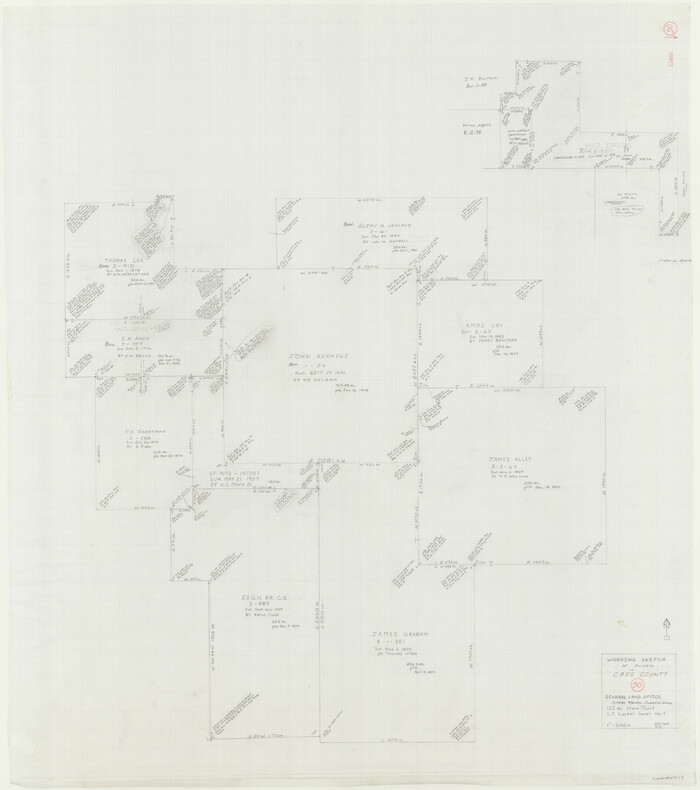
Cass County Working Sketch 50
Print $20.00
- Digital $50.00
Cass County Working Sketch 50
Size 42.6 x 37.7 inches
Map/Doc 67953
El Paso County Rolled Sketch VD

Print $40.00
- Digital $50.00
El Paso County Rolled Sketch VD
1915
Size 18.4 x 67.4 inches
Map/Doc 8862
Maverick County Sketch File 9

Print $8.00
- Digital $50.00
Maverick County Sketch File 9
1878
Size 5.3 x 5.6 inches
Map/Doc 31068
Map of Location of the Pecos & Northern Texas Railway from Station 5868+52 to Station 7879+36 = 38.08 Miles through Parmer County, Texas

Print $40.00
- Digital $50.00
Map of Location of the Pecos & Northern Texas Railway from Station 5868+52 to Station 7879+36 = 38.08 Miles through Parmer County, Texas
Size 20.2 x 108.5 inches
Map/Doc 64090
Sutton County Working Sketch 7

Print $20.00
- Digital $50.00
Sutton County Working Sketch 7
1972
Size 44.4 x 37.5 inches
Map/Doc 62350
Brewster County Rolled Sketch 114

Print $20.00
- Digital $50.00
Brewster County Rolled Sketch 114
1964
Size 17.3 x 11.4 inches
Map/Doc 5292
Jasper County Working Sketch 1

Print $20.00
- Digital $50.00
Jasper County Working Sketch 1
Size 18.2 x 23.4 inches
Map/Doc 66463
Van Zandt County Working Sketch 17

Print $20.00
- Digital $50.00
Van Zandt County Working Sketch 17
Size 17.5 x 19.1 inches
Map/Doc 72267
Medina County Rolled Sketch 18

Print $20.00
- Digital $50.00
Medina County Rolled Sketch 18
Size 33.4 x 25.3 inches
Map/Doc 6751
You may also like
Map of Burleson County

Print $20.00
- Digital $50.00
Map of Burleson County
1867
Size 19.1 x 30.0 inches
Map/Doc 4511
Medina County Rolled Sketch 4

Print $20.00
- Digital $50.00
Medina County Rolled Sketch 4
1943
Size 20.2 x 26.4 inches
Map/Doc 6740
Map of Hamilton County

Print $20.00
- Digital $50.00
Map of Hamilton County
1872
Size 15.1 x 22.1 inches
Map/Doc 4555

Fisher County Sketch File 11

Print $20.00
- Digital $50.00
Fisher County Sketch File 11
Size 22.8 x 20.4 inches
Map/Doc 11478
Calhoun County

Print $20.00
- Digital $50.00
Calhoun County
1871
Size 22.4 x 18.3 inches
Map/Doc 888
Webb County Working Sketch 61

Print $20.00
- Digital $50.00
Webb County Working Sketch 61
1960
Size 24.7 x 28.0 inches
Map/Doc 72427
Deaf Smith County, Texas / [Sec. 144, Blk. K-5]
![90623, Deaf Smith County, Texas / [Sec. 144, Blk. K-5], Twichell Survey Records](https://historictexasmaps.com/wmedia_w700/maps/90623-1.tif.jpg)
Print $20.00
- Digital $50.00
Deaf Smith County, Texas / [Sec. 144, Blk. K-5]
Size 22.9 x 22.8 inches
Map/Doc 90623
Pecos County Rolled Sketch 114

Print $856.00
- Digital $50.00
Pecos County Rolled Sketch 114
1942
Size 11.0 x 15.4 inches
Map/Doc 48104
Honey Grove, Tex., Fannin County, 1886

Print $20.00
Honey Grove, Tex., Fannin County, 1886
1886
Size 15.9 x 22.2 inches
Map/Doc 89091

Wharton County Sketch File 23

Print $20.00
- Digital $50.00
Wharton County Sketch File 23
Size 19.3 x 19.9 inches
Map/Doc 12667