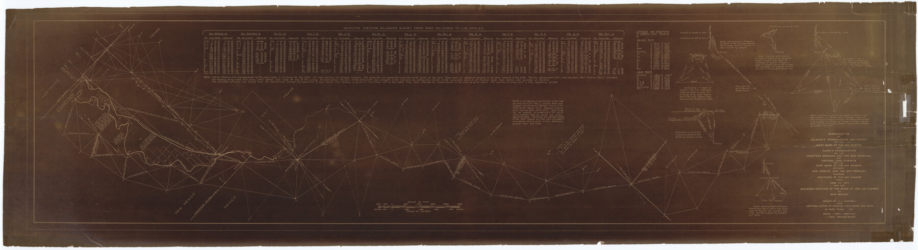
El Paso County Rolled Sketch VD
Reproduction of Salazar's Triangulation and survey of the west bank of the Rio Grande and Clark's Triangulation on the Frontera Meridian and the 32nd Parallel and original land surveys on the east bank of the Rio Grande between San Ignacio and the 32nd…
-
Map/Doc
8862
-
Collection
General Map Collection
-
Object Dates
1915 (Creation Date)
-
People and Organizations
J.L. Campbell (Draftsman)
-
Counties
El Paso
-
Subjects
Surveying Rolled Sketch
-
Height x Width
18.4 x 67.4 inches
46.7 x 171.2 cm
-
Medium
van dyke, negative
-
Scale
1" = 6000 feet
Part of: General Map Collection
Ward County Boundary File 3

Print $18.00
- Digital $50.00
Ward County Boundary File 3
Size 14.4 x 8.8 inches
Map/Doc 59675
Nueces County Rolled Sketch 52

Print $20.00
- Digital $50.00
Nueces County Rolled Sketch 52
1938
Size 31.3 x 31.7 inches
Map/Doc 9606
Kleberg County Rolled Sketch 10

Print $20.00
- Digital $50.00
Kleberg County Rolled Sketch 10
1952
Size 42.8 x 37.3 inches
Map/Doc 9397
Scurry County Boundary File 1

Print $74.00
- Digital $50.00
Scurry County Boundary File 1
Size 9.2 x 3.8 inches
Map/Doc 58597
Upton County Rolled Sketch 7

Print $62.00
- Digital $50.00
Upton County Rolled Sketch 7
1911
Size 10.5 x 15.0 inches
Map/Doc 49398
Harris County Working Sketch 5

Print $20.00
- Digital $50.00
Harris County Working Sketch 5
Size 35.1 x 28.0 inches
Map/Doc 65897
Rusk County Sketch File 43

Print $20.00
Rusk County Sketch File 43
1951
Size 23.5 x 26.6 inches
Map/Doc 12278
San Augustine County Sketch File 3

Print $10.00
San Augustine County Sketch File 3
1858
Size 11.8 x 8.1 inches
Map/Doc 35635
Stephens County Working Sketch 26

Print $20.00
- Digital $50.00
Stephens County Working Sketch 26
1976
Size 36.9 x 32.2 inches
Map/Doc 63969
Cooke County Working Sketch 37

Print $20.00
- Digital $50.00
Cooke County Working Sketch 37
1995
Size 21.7 x 18.9 inches
Map/Doc 68274
Limestone County Sketch File 23

Print $6.00
- Digital $50.00
Limestone County Sketch File 23
1908
Size 10.9 x 7.1 inches
Map/Doc 30203
Val Verde County Working Sketch 8

Print $20.00
- Digital $50.00
Val Verde County Working Sketch 8
1917
Size 31.4 x 32.0 inches
Map/Doc 72143
You may also like
Flight Mission No. DIX-10P, Frame 172, Aransas County

Print $20.00
- Digital $50.00
Flight Mission No. DIX-10P, Frame 172, Aransas County
1956
Size 18.8 x 22.3 inches
Map/Doc 83962
Jim Wells County Working Sketch 4

Print $20.00
- Digital $50.00
Jim Wells County Working Sketch 4
1938
Size 44.1 x 32.8 inches
Map/Doc 66602
Flight Mission No. DIX-10P, Frame 184, Aransas County

Print $20.00
- Digital $50.00
Flight Mission No. DIX-10P, Frame 184, Aransas County
1956
Size 18.5 x 22.2 inches
Map/Doc 83974
[B. S. & F. Block M7]
![90393, [B. S. & F. Block M7], Twichell Survey Records](https://historictexasmaps.com/wmedia_w700/maps/90393-1.tif.jpg)
Print $20.00
- Digital $50.00
[B. S. & F. Block M7]
1905
Size 21.7 x 17.9 inches
Map/Doc 90393
Flight Mission No. CRC-2R, Frame 179, Chambers County

Print $20.00
- Digital $50.00
Flight Mission No. CRC-2R, Frame 179, Chambers County
1956
Size 18.6 x 22.3 inches
Map/Doc 84757
Matagorda County Rolled Sketch 37C

Print $20.00
- Digital $50.00
Matagorda County Rolled Sketch 37C
Size 11.6 x 14.3 inches
Map/Doc 10197
Hidalgo County Sketch File 11

Print $40.00
- Digital $50.00
Hidalgo County Sketch File 11
1908
Size 18.5 x 13.6 inches
Map/Doc 26429

Starr County Boundary File 2

Print $8.00
- Digital $50.00
Starr County Boundary File 2
Size 11.0 x 7.4 inches
Map/Doc 58814
El Paso County Sketch File 30

Print $4.00
- Digital $50.00
El Paso County Sketch File 30
1960
Size 11.2 x 8.8 inches
Map/Doc 22082
Pecos County Working Sketch 110

Print $40.00
- Digital $50.00
Pecos County Working Sketch 110
1972
Size 32.3 x 50.6 inches
Map/Doc 71583
Lee County Sketch File 1

Print $4.00
- Digital $50.00
Lee County Sketch File 1
1856
Size 13.1 x 8.2 inches
Map/Doc 29678