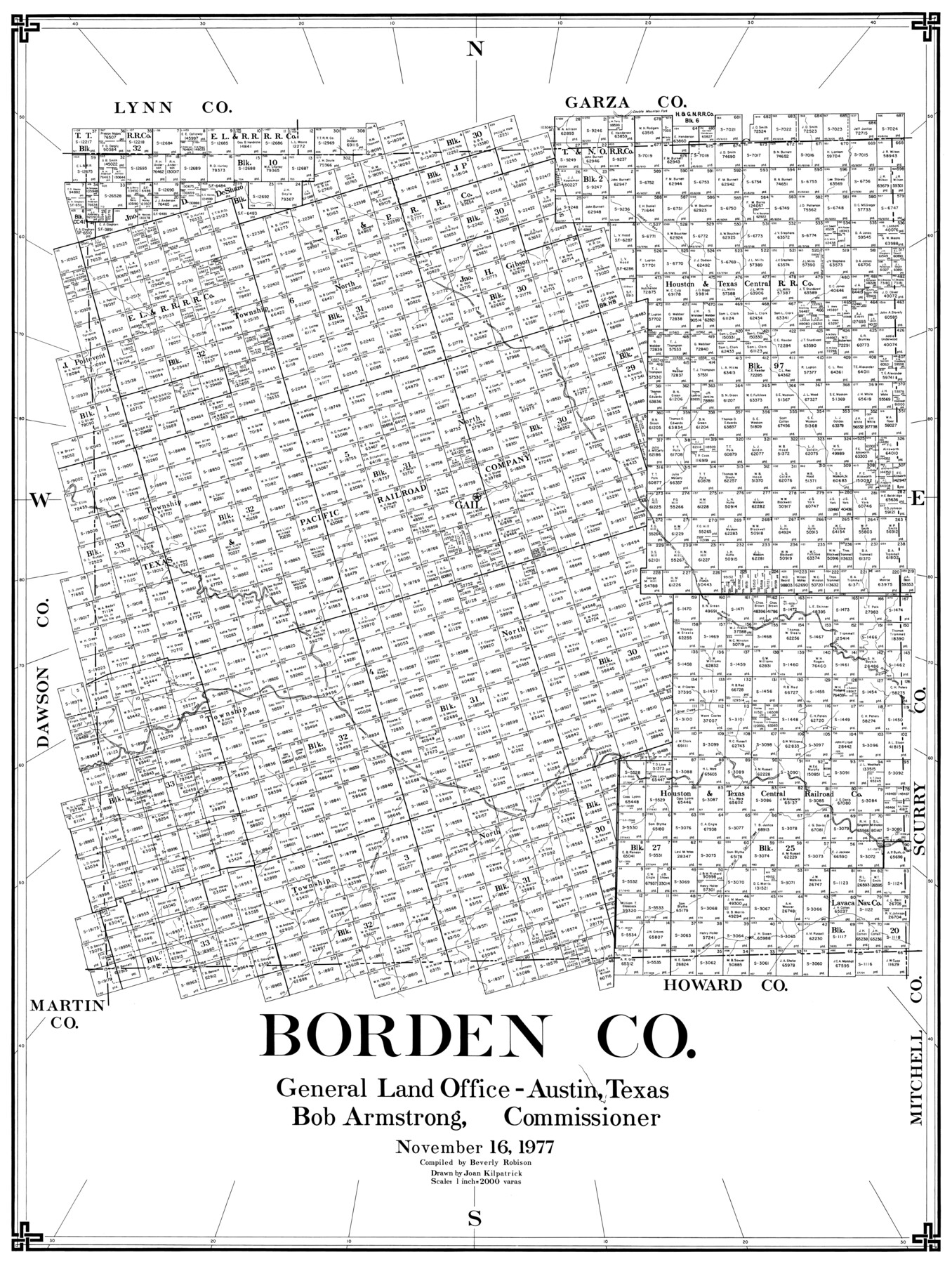
Borden Co.
-
Map/Doc
77214
-
Collection
General Map Collection
-
Object Dates
1977/11/16 (Creation Date)
-
People and Organizations
Beverly Robison (Compiler)
Joan Kilpatrick (Draftsman)
-
Counties
Borden
-
Subjects
County
-
Height x Width
43.5 x 32.9 inches
110.5 x 83.6 cm
Part of: General Map Collection
Palo Pinto County Sketch File A

Print $6.00
- Digital $50.00
Palo Pinto County Sketch File A
Size 8.7 x 4.1 inches
Map/Doc 33389
Flight Mission No. DIX-10P, Frame 83, Aransas County

Print $20.00
- Digital $50.00
Flight Mission No. DIX-10P, Frame 83, Aransas County
1956
Size 18.7 x 22.3 inches
Map/Doc 83944

Hansford County Working Sketch 3

Print $20.00
- Digital $50.00
Hansford County Working Sketch 3
1940
Size 20.5 x 16.5 inches
Map/Doc 63375
Freestone County Boundary File 30d

Print $20.00
- Digital $50.00
Freestone County Boundary File 30d
Size 8.0 x 29.6 inches
Map/Doc 53608
Loving County Working Sketch 3

Print $20.00
- Digital $50.00
Loving County Working Sketch 3
1941
Size 18.0 x 42.2 inches
Map/Doc 70635
Collin County Working Sketch Graphic Index

Print $20.00
- Digital $50.00
Collin County Working Sketch Graphic Index
1975
Size 41.4 x 39.0 inches
Map/Doc 76498
Aransas County Sketch File 7

Print $4.00
- Digital $50.00
Aransas County Sketch File 7
Size 12.7 x 7.9 inches
Map/Doc 13112
Crockett County Rolled Sketch 88C

Print $20.00
- Digital $50.00
Crockett County Rolled Sketch 88C
1973
Size 36.3 x 38.1 inches
Map/Doc 8728
[St. Louis & Southwestern]
![64281, [St. Louis & Southwestern], General Map Collection](https://historictexasmaps.com/wmedia_w700/maps/64281.tif.jpg)
Print $20.00
- Digital $50.00
[St. Louis & Southwestern]
Size 20.9 x 29.0 inches
Map/Doc 64281
[St. Louis & Southwestern]
![64279, [St. Louis & Southwestern], General Map Collection](https://historictexasmaps.com/wmedia_w700/maps/64279.tif.jpg)
Print $20.00
- Digital $50.00
[St. Louis & Southwestern]
Size 20.7 x 28.5 inches
Map/Doc 64279
Flight Mission No. CRK-8P, Frame 106, Refugio County

Print $20.00
- Digital $50.00
Flight Mission No. CRK-8P, Frame 106, Refugio County
1956
Size 18.3 x 22.1 inches
Map/Doc 86967
You may also like
Brazoria County Boundary File 1

Print $10.00
- Digital $50.00
Brazoria County Boundary File 1
Size 14.4 x 8.7 inches
Map/Doc 50699
Sketch in Hockley County, Texas

Print $20.00
- Digital $50.00
Sketch in Hockley County, Texas
Size 10.7 x 31.4 inches
Map/Doc 91199
Brooks County Rolled Sketch 27

Print $20.00
- Digital $50.00
Brooks County Rolled Sketch 27
1945
Size 44.5 x 42.9 inches
Map/Doc 8540
Ward County Working Sketch 25

Print $40.00
- Digital $50.00
Ward County Working Sketch 25
1957
Size 74.3 x 25.6 inches
Map/Doc 72331
Dawson County

Print $20.00
- Digital $50.00
Dawson County
1959
Size 43.1 x 35.1 inches
Map/Doc 95476
Childress County Sketch File 24

Print $4.00
- Digital $50.00
Childress County Sketch File 24
1917
Size 12.9 x 8.6 inches
Map/Doc 18384
Carson County Working Sketch 1

Print $40.00
- Digital $50.00
Carson County Working Sketch 1
Size 44.6 x 77.4 inches
Map/Doc 67872
Amistad International Reservoir on Rio Grande 95a

Print $20.00
- Digital $50.00
Amistad International Reservoir on Rio Grande 95a
1950
Size 28.8 x 41.2 inches
Map/Doc 75526
Lamb County Sketch File 5

Print $20.00
- Digital $50.00
Lamb County Sketch File 5
Size 23.3 x 31.1 inches
Map/Doc 11971
[Map of Texas showing Frisco Lines]
![95796, [Map of Texas showing Frisco Lines], Cobb Digital Map Collection](https://historictexasmaps.com/wmedia_w700/maps/95796.tif.jpg)
Print $20.00
- Digital $50.00
[Map of Texas showing Frisco Lines]
1910
Size 19.8 x 19.2 inches
Map/Doc 95796
Flight Mission No. DQO-8K, Frame 55, Galveston County

Print $20.00
- Digital $50.00
Flight Mission No. DQO-8K, Frame 55, Galveston County
1952
Size 18.7 x 22.5 inches
Map/Doc 85162
Schleicher County Rolled Sketch 2

Print $20.00
- Digital $50.00
Schleicher County Rolled Sketch 2
1888
Size 25.8 x 32.6 inches
Map/Doc 7746