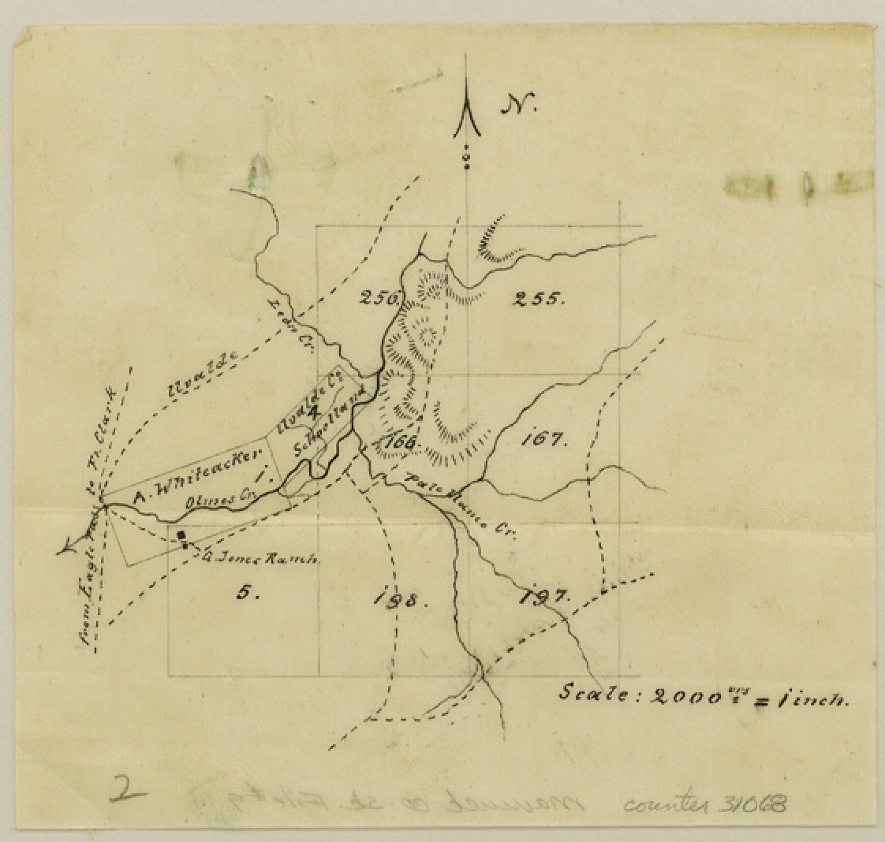
Maverick County Sketch File 9
[Sketch and field notes of connecting line northeast of Eagle Pass]
-
Map/Doc
31068
-
Collection
General Map Collection
-
Object Dates
3/1878 (Creation Date)
3/28/1878 (File Date)
-
People and Organizations
A. Wyschetzki (Surveyor/Engineer)
-
Counties
Maverick
-
Subjects
Surveying Sketch File
-
Height x Width
5.3 x 5.6 inches
13.5 x 14.2 cm
-
Medium
paper, manuscript
-
Scale
1" = 2000 varas
-
Features
Saus Creek
Leon Creek
Palo Blanco Creek
[Stage Road] from Eagle Pass to Fort Clark
A. James Ranch
Olmos Creek
Part of: General Map Collection
Andrews County Rolled Sketch 27

Print $40.00
- Digital $50.00
Andrews County Rolled Sketch 27
1947
Size 19.0 x 118.7 inches
Map/Doc 8399
Plat of a survey of the North part of section 16, Block 362, Martha McBride, Presidio County, Texas

Print $20.00
- Digital $50.00
Plat of a survey of the North part of section 16, Block 362, Martha McBride, Presidio County, Texas
1989
Size 24.3 x 36.1 inches
Map/Doc 60523
Hutchinson County Sketch File 3

Print $4.00
- Digital $50.00
Hutchinson County Sketch File 3
Size 8.2 x 12.8 inches
Map/Doc 27177
[Surveys along the Brazos River]
![71, [Surveys along the Brazos River], General Map Collection](https://historictexasmaps.com/wmedia_w700/maps/71.tif.jpg)
Print $3.00
- Digital $50.00
[Surveys along the Brazos River]
1840
Size 16.2 x 9.4 inches
Map/Doc 71
Flight Mission No. DCL-7C, Frame 5, Kenedy County

Print $20.00
- Digital $50.00
Flight Mission No. DCL-7C, Frame 5, Kenedy County
1943
Size 18.5 x 22.3 inches
Map/Doc 85997
Shackelford County Sketch File 2

Print $4.00
- Digital $50.00
Shackelford County Sketch File 2
1870
Size 9.3 x 9.0 inches
Map/Doc 36572
Kleberg County Rolled Sketch 10-28

Print $20.00
- Digital $50.00
Kleberg County Rolled Sketch 10-28
1952
Size 36.2 x 33.9 inches
Map/Doc 9375
Fayette County Sketch File 4

Print $4.00
- Digital $50.00
Fayette County Sketch File 4
Size 11.7 x 7.9 inches
Map/Doc 22504
Pecos County Working Sketch 85

Print $20.00
- Digital $50.00
Pecos County Working Sketch 85
1962
Size 45.4 x 35.7 inches
Map/Doc 71557
Crockett County Rolled Sketch 98

Print $40.00
- Digital $50.00
Crockett County Rolled Sketch 98
2021
Size 36.5 x 48.3 inches
Map/Doc 96577
Pecos County Rolled Sketch 72

Print $30.00
- Digital $50.00
Pecos County Rolled Sketch 72
1934
Size 35.8 x 45.1 inches
Map/Doc 9704
Pecos County Rolled Sketch 177

Print $20.00
- Digital $50.00
Pecos County Rolled Sketch 177
1972
Size 27.4 x 38.0 inches
Map/Doc 7297
You may also like
Flight Mission No. CGI-3N, Frame 70, Cameron County

Print $20.00
- Digital $50.00
Flight Mission No. CGI-3N, Frame 70, Cameron County
1954
Size 18.7 x 22.3 inches
Map/Doc 84564
Fisher County Sketch File 9

Print $4.00
- Digital $50.00
Fisher County Sketch File 9
1893
Size 11.1 x 8.5 inches
Map/Doc 22575
Jasper County Sketch File 24

Print $4.00
- Digital $50.00
Jasper County Sketch File 24
1925
Size 10.9 x 8.3 inches
Map/Doc 27824
Dimmit County Sketch File 44

Print $20.00
- Digital $50.00
Dimmit County Sketch File 44
Size 16.3 x 19.5 inches
Map/Doc 11354
Coke County Rolled Sketch 17

Print $20.00
- Digital $50.00
Coke County Rolled Sketch 17
1953
Size 36.1 x 45.2 inches
Map/Doc 8631
Southern Pacific Lines in Texas and Louisiana (G. H. & S. A. Ry.) Circuit Plan of Automatic Block Signals, Automatic Train Control and Flatonia Interlocking Plant No. 3

Print $40.00
- Digital $50.00
Southern Pacific Lines in Texas and Louisiana (G. H. & S. A. Ry.) Circuit Plan of Automatic Block Signals, Automatic Train Control and Flatonia Interlocking Plant No. 3
1927
Size 43.5 x 215.5 inches
Map/Doc 90044
Presidio County Sketch File 92

Print $10.00
- Digital $50.00
Presidio County Sketch File 92
1958
Size 11.2 x 8.8 inches
Map/Doc 34765
Val Verde County Working Sketch 43

Print $20.00
- Digital $50.00
Val Verde County Working Sketch 43
1945
Size 39.3 x 37.2 inches
Map/Doc 72178
Sutton County Working Sketch 23

Print $20.00
- Digital $50.00
Sutton County Working Sketch 23
1981
Size 17.3 x 27.1 inches
Map/Doc 62366
Randall County Boundary File 4

Print $10.00
- Digital $50.00
Randall County Boundary File 4
Size 14.4 x 8.9 inches
Map/Doc 58129
Map of Clear Lake Shores

Print $20.00
- Digital $50.00
Map of Clear Lake Shores
1927
Size 36.9 x 46.2 inches
Map/Doc 4843
Republic Counties. January 1, 1840

Print $20.00
Republic Counties. January 1, 1840
2020
Size 24.5 x 21.7 inches
Map/Doc 96313