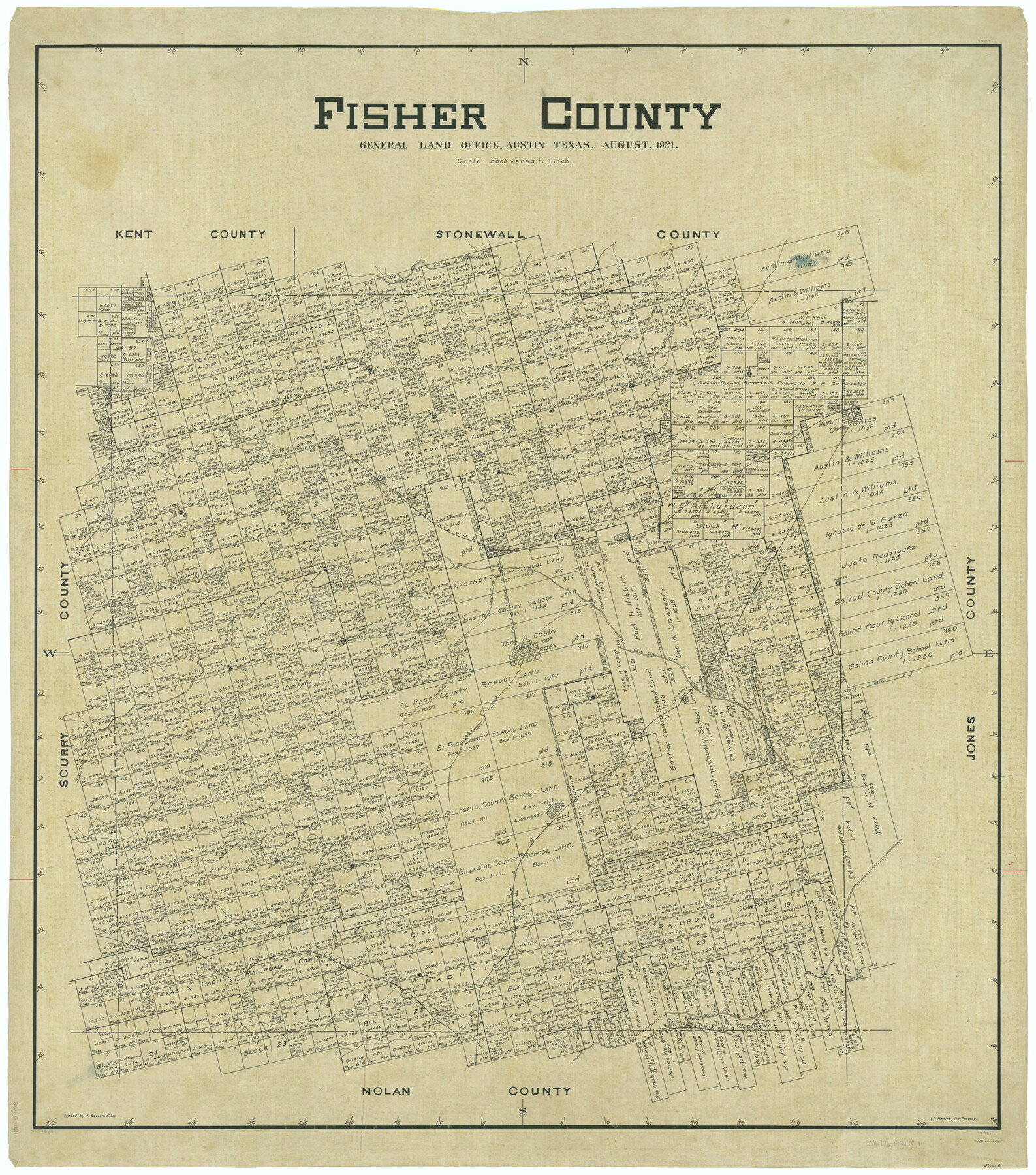
Fisher County
-
Map/Doc
66822
-
Collection
General Map Collection
-
Object Dates
1921 (Creation Date)
-
People and Organizations
Texas General Land Office (Publisher)
John D. Hedick (Draftsman)
John D. Hedick (Compiler)
-
Counties
Fisher
-
Subjects
County
-
Height x Width
45.8 x 40.4 inches
116.3 x 102.6 cm
-
Comments
Traced by J. Bascom Giles.
Part of: General Map Collection
Crockett County Sketch File 21

Print $18.00
- Digital $50.00
Crockett County Sketch File 21
Size 13.6 x 8.4 inches
Map/Doc 19682
Flight Mission No. DQO-8K, Frame 39, Galveston County

Print $20.00
- Digital $50.00
Flight Mission No. DQO-8K, Frame 39, Galveston County
1952
Size 18.7 x 22.4 inches
Map/Doc 85146
Eastland County Sketch File 9

Print $4.00
- Digital $50.00
Eastland County Sketch File 9
Size 10.5 x 8.2 inches
Map/Doc 21580
Armstrong County

Print $20.00
- Digital $50.00
Armstrong County
1904
Size 45.7 x 40.6 inches
Map/Doc 4876
Sterling County Working Sketch 10

Print $20.00
- Digital $50.00
Sterling County Working Sketch 10
1980
Size 39.6 x 26.3 inches
Map/Doc 63992
[Beaumont, Sour Lake and Western Ry. Right of Way and Alignment - Frisco]
![64120, [Beaumont, Sour Lake and Western Ry. Right of Way and Alignment - Frisco], General Map Collection](https://historictexasmaps.com/wmedia_w700/maps/64120.tif.jpg)
Print $20.00
- Digital $50.00
[Beaumont, Sour Lake and Western Ry. Right of Way and Alignment - Frisco]
1910
Size 19.7 x 45.6 inches
Map/Doc 64120
Clay County Sketch File 1

Print $22.00
- Digital $50.00
Clay County Sketch File 1
1855
Size 8.9 x 7.6 inches
Map/Doc 18386
The University of Texas at Austin

The University of Texas at Austin
Size 16.1 x 17.1 inches
Map/Doc 94387
Corpus Christi Bay, Texas

Print $40.00
- Digital $50.00
Corpus Christi Bay, Texas
1867
Size 33.9 x 54.8 inches
Map/Doc 73470
Williamson County Rolled Sketch 3

Print $20.00
- Digital $50.00
Williamson County Rolled Sketch 3
1915
Size 40.1 x 30.9 inches
Map/Doc 8261
Matagorda Light to Aransas Pass

Print $20.00
- Digital $50.00
Matagorda Light to Aransas Pass
1924
Size 35.9 x 44.6 inches
Map/Doc 73391
Wilson County Boundary File 9

Print $42.00
- Digital $50.00
Wilson County Boundary File 9
Size 14.3 x 8.9 inches
Map/Doc 60119
You may also like
Crane County Sketch File 28

Print $6.00
- Digital $50.00
Crane County Sketch File 28
1953
Size 11.5 x 9.1 inches
Map/Doc 19605
[Block 3 on East side of County]
![90606, [Block 3 on East side of County], Twichell Survey Records](https://historictexasmaps.com/wmedia_w700/maps/90606-1.tif.jpg)
Print $20.00
- Digital $50.00
[Block 3 on East side of County]
Size 16.9 x 19.8 inches
Map/Doc 90606

Maverick County Working Sketch 2

Print $20.00
- Digital $50.00
Maverick County Working Sketch 2
1922
Size 46.2 x 38.5 inches
Map/Doc 70894
Kleberg County Rolled Sketch 10-32

Print $20.00
- Digital $50.00
Kleberg County Rolled Sketch 10-32
1952
Size 36.2 x 34.5 inches
Map/Doc 9369
Gregg County Sketch File 10

Print $20.00
- Digital $50.00
Gregg County Sketch File 10
1932
Size 35.1 x 26.0 inches
Map/Doc 11588
Texas, Matagorda Bay, Matagorda Peninsula, Cany Creek to Tiger Island Channel

Print $40.00
- Digital $50.00
Texas, Matagorda Bay, Matagorda Peninsula, Cany Creek to Tiger Island Channel
1933
Size 31.4 x 48.6 inches
Map/Doc 69991
Harris County

Print $20.00
- Digital $50.00
Harris County
1940
Size 37.7 x 46.4 inches
Map/Doc 95522
Bandera County

Print $40.00
- Digital $50.00
Bandera County
1947
Size 33.9 x 54.9 inches
Map/Doc 73075
Kinney County Working Sketch 41

Print $20.00
- Digital $50.00
Kinney County Working Sketch 41
1973
Size 36.2 x 44.2 inches
Map/Doc 70223
Polk County Rolled Sketch 32

Print $20.00
- Digital $50.00
Polk County Rolled Sketch 32
Size 21.6 x 15.8 inches
Map/Doc 7318
[Lubbock, Crosby County Line]
![91323, [Lubbock, Crosby County Line], Twichell Survey Records](https://historictexasmaps.com/wmedia_w700/maps/91323-1.tif.jpg)
Print $2.00
- Digital $50.00
[Lubbock, Crosby County Line]
Size 9.2 x 14.7 inches
Map/Doc 91323