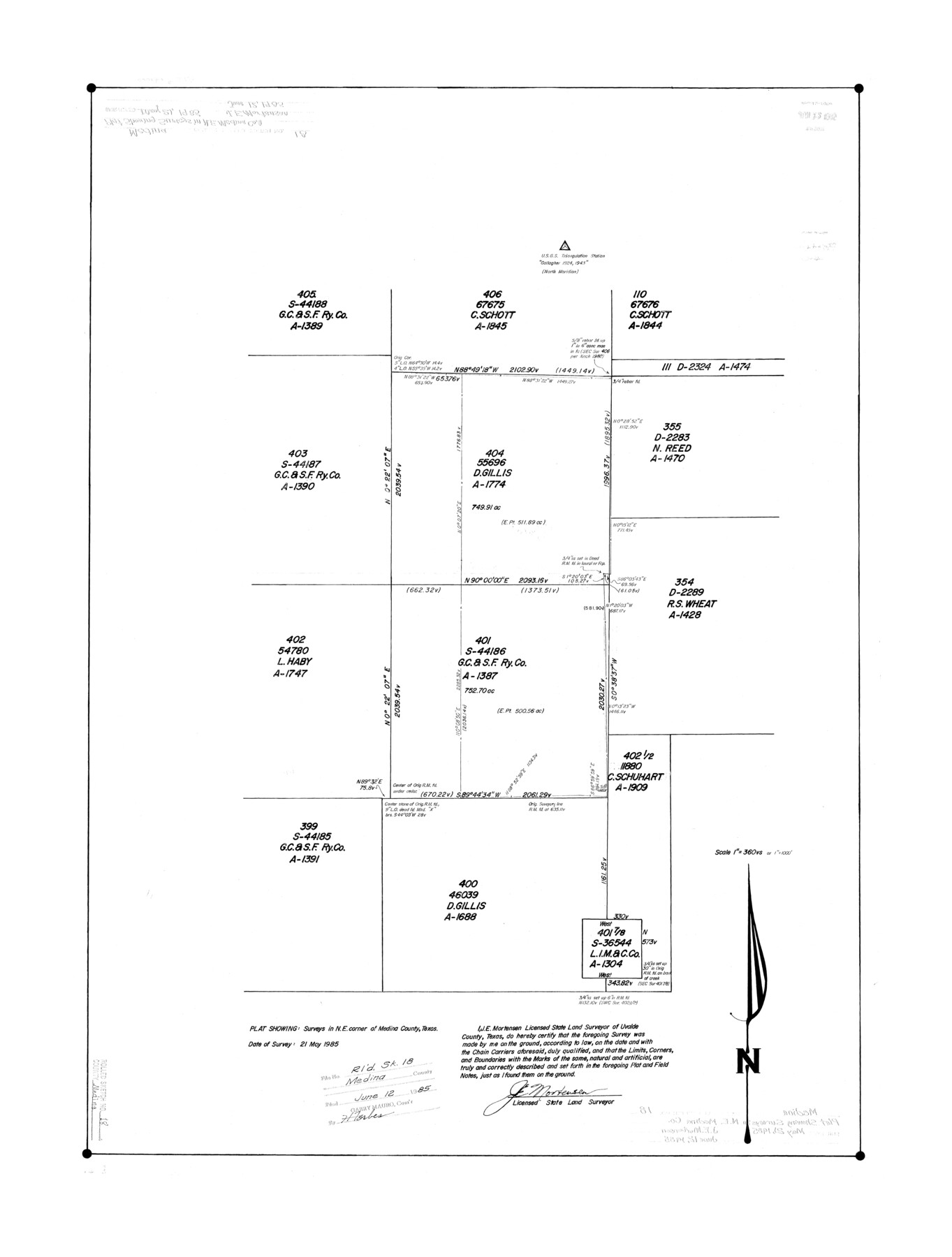
Medina County Rolled Sketch 18
Plat showing surveys in NE corner of Medina County, Texas
-
Map/Doc
6751
-
Collection
General Map Collection
-
Object Dates
1985/5/21 (Survey Date)
1985/6/12 (File Date)
-
People and Organizations
James E. Mortensen (Surveyor/Engineer)
-
Counties
Medina
-
Subjects
Surveying Rolled Sketch
-
Height x Width
33.4 x 25.3 inches
84.8 x 64.3 cm
-
Scale
1" = 360 varas
Part of: General Map Collection
Map of Kinney County

Print $20.00
- Digital $50.00
Map of Kinney County
1875
Size 25.9 x 34.2 inches
Map/Doc 3773
Polk County Sketch File 20

Print $4.00
- Digital $50.00
Polk County Sketch File 20
Size 6.1 x 8.2 inches
Map/Doc 34167
San Patricio County Working Sketch 18

Print $20.00
- Digital $50.00
San Patricio County Working Sketch 18
1955
Size 19.3 x 24.4 inches
Map/Doc 63780
McMullen County Sketch File 43

Print $10.00
- Digital $50.00
McMullen County Sketch File 43
1942
Size 14.2 x 8.8 inches
Map/Doc 31421
Val Verde County Working Sketch 51

Print $20.00
- Digital $50.00
Val Verde County Working Sketch 51
1952
Size 24.5 x 30.0 inches
Map/Doc 72186
Burleson County Working Sketch 12

Print $20.00
- Digital $50.00
Burleson County Working Sketch 12
1980
Size 20.6 x 12.0 inches
Map/Doc 67731
Travis County State Real Property Sketch 5

Print $20.00
- Digital $50.00
Travis County State Real Property Sketch 5
1990
Size 25.4 x 37.5 inches
Map/Doc 61696
Brown County Working Sketch 6

Print $20.00
- Digital $50.00
Brown County Working Sketch 6
1948
Size 12.9 x 19.3 inches
Map/Doc 67771
Brooks County Rolled Sketch 24

Print $20.00
- Digital $50.00
Brooks County Rolled Sketch 24
1945
Size 42.8 x 23.7 inches
Map/Doc 5344
Swisher County Rolled Sketch 7

Print $40.00
- Digital $50.00
Swisher County Rolled Sketch 7
1955
Size 65.0 x 43.5 inches
Map/Doc 9983
Coleman County Working Sketch 15

Print $20.00
- Digital $50.00
Coleman County Working Sketch 15
1952
Size 24.3 x 18.1 inches
Map/Doc 68081
PSL Field Notes for Block 54 1/2 in Culberson and Hudspeth Counties, and Blocks 44, 45 1/2, 46, 47 1/2, 48, 49, 50, 51, 52 1/2, 53 1/2, 55 1/2, 56, and 57 in Hudspeth County

PSL Field Notes for Block 54 1/2 in Culberson and Hudspeth Counties, and Blocks 44, 45 1/2, 46, 47 1/2, 48, 49, 50, 51, 52 1/2, 53 1/2, 55 1/2, 56, and 57 in Hudspeth County
Map/Doc 81661
You may also like
Hudspeth County Rolled Sketch 43B

Print $20.00
- Digital $50.00
Hudspeth County Rolled Sketch 43B
1935
Size 11.0 x 17.3 inches
Map/Doc 6253
Harris County Working Sketch 113

Print $20.00
- Digital $50.00
Harris County Working Sketch 113
1982
Size 28.6 x 40.7 inches
Map/Doc 66005
Flight Mission No. DAG-21K, Frame 116, Matagorda County

Print $20.00
- Digital $50.00
Flight Mission No. DAG-21K, Frame 116, Matagorda County
1952
Size 18.6 x 22.3 inches
Map/Doc 86439
Gonzales County Sketch File 9

Print $7.00
- Digital $50.00
Gonzales County Sketch File 9
1841
Size 10.1 x 8.2 inches
Map/Doc 24387
Webb County Working Sketch 24

Print $20.00
- Digital $50.00
Webb County Working Sketch 24
1928
Size 24.5 x 23.9 inches
Map/Doc 72389
Flight Mission No. BRE-1P, Frame 81, Nueces County

Print $20.00
- Digital $50.00
Flight Mission No. BRE-1P, Frame 81, Nueces County
1956
Size 18.3 x 22.1 inches
Map/Doc 86663
Controlled Mosaic by Jack Amman Photogrammetric Engineers, Inc - Sheet 36

Print $20.00
- Digital $50.00
Controlled Mosaic by Jack Amman Photogrammetric Engineers, Inc - Sheet 36
1954
Size 20.0 x 24.0 inches
Map/Doc 83489
Hockley County Rolled Sketch 3

Print $40.00
- Digital $50.00
Hockley County Rolled Sketch 3
Size 82.9 x 29.4 inches
Map/Doc 9173
Panola County Working Sketch 34

Print $20.00
- Digital $50.00
Panola County Working Sketch 34
1983
Map/Doc 71443
Reyno de la Nueva España a Principios del Siglo XIX

Print $20.00
- Digital $50.00
Reyno de la Nueva España a Principios del Siglo XIX
1885
Size 25.6 x 32.7 inches
Map/Doc 93751
Milam County Sketch File 1

Print $4.00
- Digital $50.00
Milam County Sketch File 1
1848
Size 10.7 x 7.8 inches
Map/Doc 31624
Trinity County Boundary File 102

Print $14.00
- Digital $50.00
Trinity County Boundary File 102
Size 9.2 x 4.6 inches
Map/Doc 59480