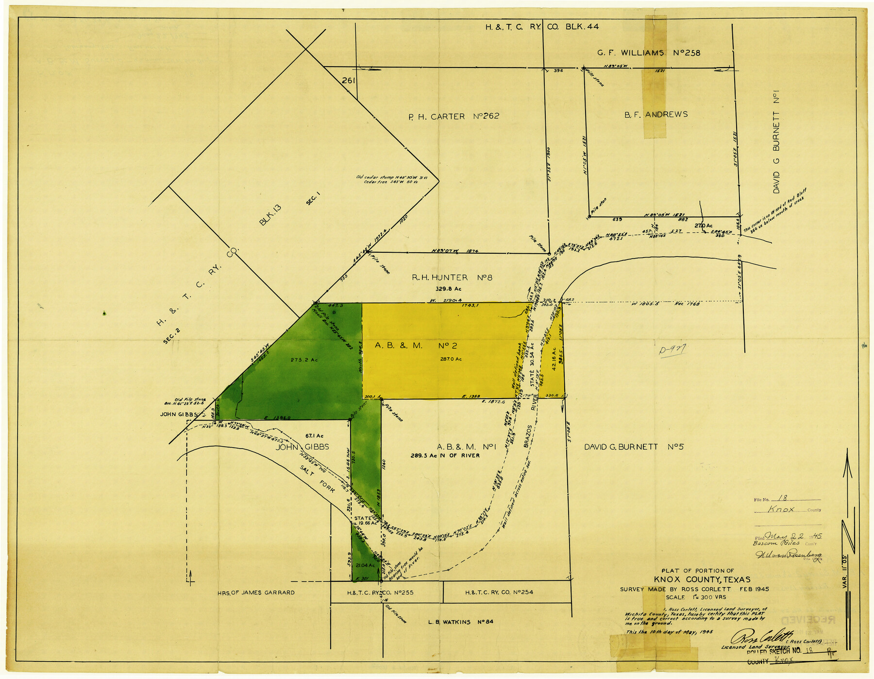
Knox County Rolled Sketch 18
Plat of portion of Knox County, Texas
-
Map/Doc
6558
-
Collection
General Map Collection
-
Object Dates
5/10/1945 (Creation Date)
5/22/1945 (File Date)
2/1945 (Survey Date)
-
People and Organizations
Ross Corlett (Surveyor/Engineer)
-
Counties
Knox
-
Subjects
Surveying Rolled Sketch
-
Height x Width
23.1 x 29.5 inches
58.7 x 74.9 cm
-
Medium
blueprint/diazo
-
Scale
1" = 300 varas
-
Comments
See Knox County Sketch File 24 (29254) for report.
Related maps
Knox County Sketch File 24

Print $6.00
- Digital $50.00
Knox County Sketch File 24
1945
Size 14.2 x 9.0 inches
Map/Doc 29254
Part of: General Map Collection
Presidio County Rolled Sketch 140

Print $20.00
- Digital $50.00
Presidio County Rolled Sketch 140
2003
Size 44.4 x 34.7 inches
Map/Doc 78654
Winkler County

Print $20.00
- Digital $50.00
Winkler County
1932
Size 39.4 x 39.5 inches
Map/Doc 63132
Edwards County Working Sketch 41

Print $20.00
- Digital $50.00
Edwards County Working Sketch 41
1949
Size 29.5 x 30.7 inches
Map/Doc 68917
Zavala County Working Sketch 31

Print $20.00
- Digital $50.00
Zavala County Working Sketch 31
2019
Size 36.0 x 24.2 inches
Map/Doc 95407
Current Miscellaneous File 9

Print $66.00
- Digital $50.00
Current Miscellaneous File 9
Size 6.5 x 8.2 inches
Map/Doc 73741
Lamar County Sketch File 7

Print $4.00
- Digital $50.00
Lamar County Sketch File 7
1880
Size 9.0 x 6.9 inches
Map/Doc 29288
Fisher County Working Sketch 19

Print $20.00
- Digital $50.00
Fisher County Working Sketch 19
1962
Size 26.2 x 25.5 inches
Map/Doc 69153
Kenedy County Aerial Photograph Index Sheet 2

Print $20.00
- Digital $50.00
Kenedy County Aerial Photograph Index Sheet 2
1943
Size 23.1 x 19.3 inches
Map/Doc 83714
Jack County Working Sketch 14

Print $20.00
- Digital $50.00
Jack County Working Sketch 14
1981
Size 28.2 x 30.2 inches
Map/Doc 66440
Wichita County Working Sketch 14

Print $20.00
- Digital $50.00
Wichita County Working Sketch 14
1922
Size 20.8 x 42.1 inches
Map/Doc 72524
Zapata County Rolled Sketch 21

Print $155.00
- Digital $50.00
Zapata County Rolled Sketch 21
Size 10.4 x 15.2 inches
Map/Doc 49589
Flight Mission No. BRE-2P, Frame 77, Nueces County

Print $20.00
- Digital $50.00
Flight Mission No. BRE-2P, Frame 77, Nueces County
1956
Size 18.4 x 22.2 inches
Map/Doc 86772
You may also like
Hudspeth County Working Sketch 38

Print $20.00
- Digital $50.00
Hudspeth County Working Sketch 38
1978
Size 31.8 x 36.9 inches
Map/Doc 66323
Foard County Sketch File 13

Print $6.00
- Digital $50.00
Foard County Sketch File 13
1885
Size 13.0 x 8.5 inches
Map/Doc 22816
Dimmit County

Print $40.00
- Digital $50.00
Dimmit County
1976
Size 42.2 x 48.9 inches
Map/Doc 77265
Denton County Sketch File 43

Print $20.00
- Digital $50.00
Denton County Sketch File 43
2006
Size 11.0 x 8.5 inches
Map/Doc 83610
Bailey County Rolled Sketch 6

Print $20.00
- Digital $50.00
Bailey County Rolled Sketch 6
Size 17.4 x 12.9 inches
Map/Doc 5111
Eastland County Working Sketch 42

Print $20.00
- Digital $50.00
Eastland County Working Sketch 42
1979
Size 43.5 x 35.0 inches
Map/Doc 68823
Cass County Rolled Sketch BRR

Print $40.00
- Digital $50.00
Cass County Rolled Sketch BRR
1936
Size 67.3 x 28.0 inches
Map/Doc 8581
Morris County Working Sketch 5

Print $20.00
- Digital $50.00
Morris County Working Sketch 5
1965
Size 24.7 x 18.9 inches
Map/Doc 71204
Map of Nacogdoches County

Print $20.00
- Digital $50.00
Map of Nacogdoches County
1881
Size 24.1 x 21.2 inches
Map/Doc 4603
Shelby County Sketch File 33

Print $8.00
- Digital $50.00
Shelby County Sketch File 33
1949
Size 11.5 x 9.0 inches
Map/Doc 36670

Deaf Smith County Working Sketch 2
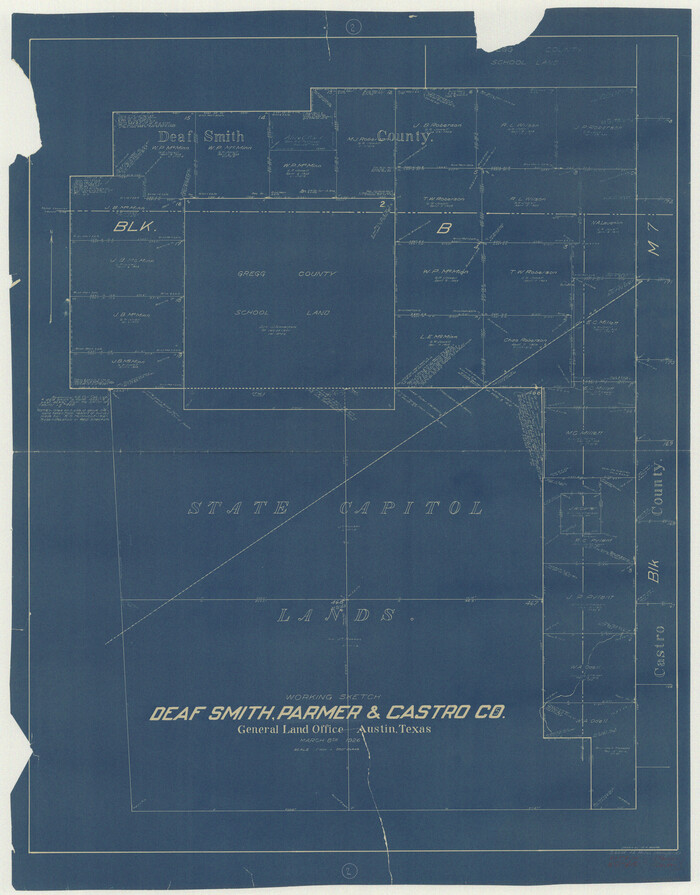
Print $20.00
- Digital $50.00
Deaf Smith County Working Sketch 2
1926
Size 42.3 x 33.1 inches
Map/Doc 68642