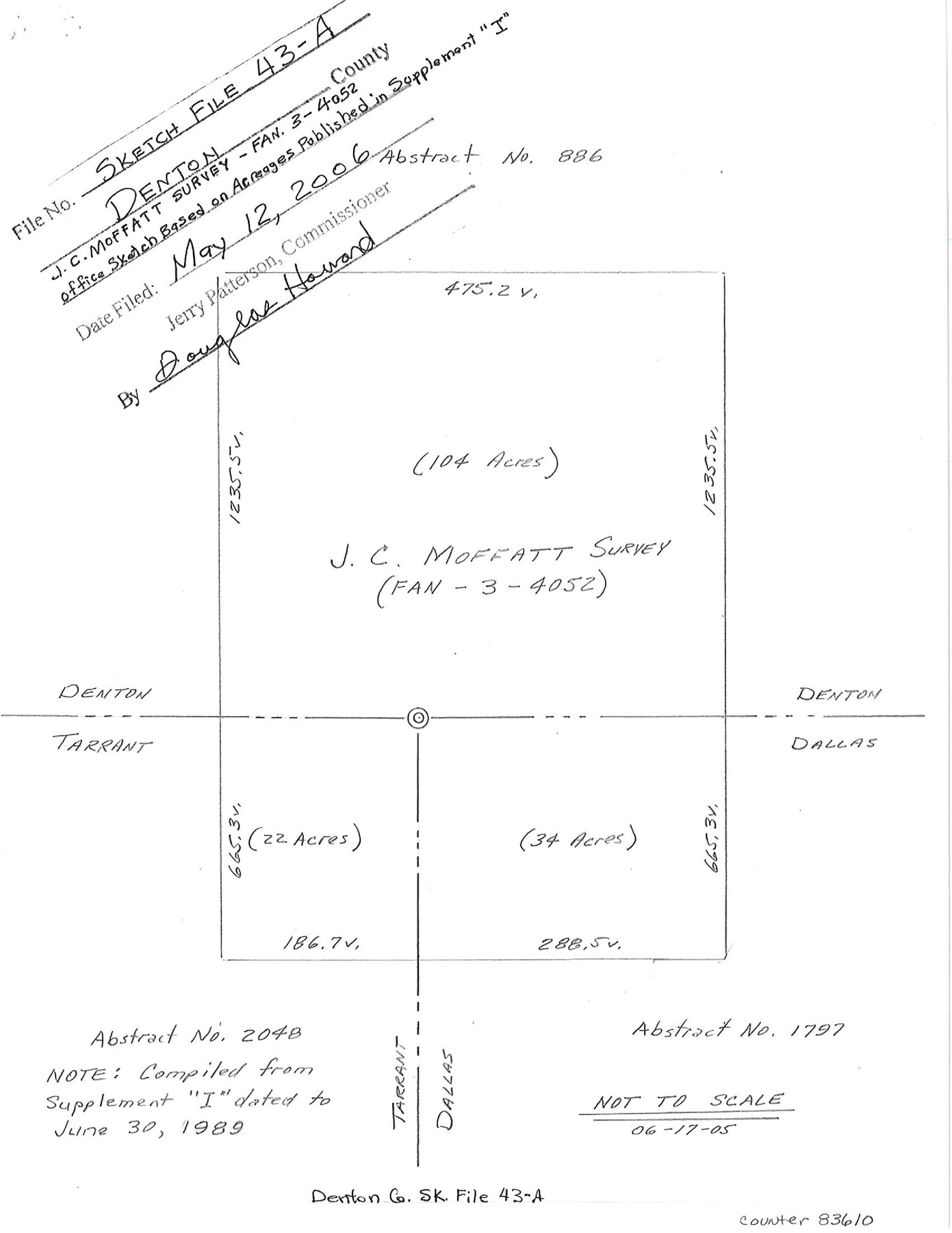
Denton County Sketch File 43
[Sketch and documentation of J. C. Moffatt survey, FAN 3-4052 - office sketch based on acreages published in Supplement "I"]
-
Map/Doc
83610
-
Collection
General Map Collection
-
Object Dates
5/12/2006 (Creation Date)
5/12/2006 (File Date)
-
People and Organizations
Texas General Land Office (Publisher)
Texas General Land Office (Printer)
Jerry E. Patterson (GLO Commissioner)
-
Counties
Denton Tarrant Dallas
-
Subjects
Surveying Sketch File
-
Height x Width
11.0 x 8.5 inches
27.9 x 21.6 cm
-
Medium
paper, manuscript
-
Features
Denton Creek
Grapevine
SLS
Carrollton
Elm Fork of Trinity River
Grapevine Creek
Hackberry Creek
Part of: General Map Collection
Flight Mission No. BRA-8M, Frame 76, Jefferson County

Print $20.00
- Digital $50.00
Flight Mission No. BRA-8M, Frame 76, Jefferson County
1953
Size 18.5 x 22.3 inches
Map/Doc 85596
Northern Part of Laguna Madre

Print $20.00
- Digital $50.00
Northern Part of Laguna Madre
1992
Size 45.4 x 35.3 inches
Map/Doc 73532
Flight Mission No. DCL-7C, Frame 23, Kenedy County

Print $20.00
- Digital $50.00
Flight Mission No. DCL-7C, Frame 23, Kenedy County
1943
Size 15.4 x 15.2 inches
Map/Doc 86015
Intracoastal Waterway, Houma, LA to Corpus Christi, TX

Print $20.00
- Digital $50.00
Intracoastal Waterway, Houma, LA to Corpus Christi, TX
Size 26.6 x 20.8 inches
Map/Doc 61907
Railroad Track Map, H&TCRRCo., Falls County, Texas

Print $4.00
- Digital $50.00
Railroad Track Map, H&TCRRCo., Falls County, Texas
1918
Size 11.6 x 18.3 inches
Map/Doc 62855
Montgomery County Working Sketch 32

Print $20.00
- Digital $50.00
Montgomery County Working Sketch 32
1950
Size 32.8 x 32.8 inches
Map/Doc 71139
Flight Mission No. BRA-6M, Frame 88, Jefferson County

Print $20.00
- Digital $50.00
Flight Mission No. BRA-6M, Frame 88, Jefferson County
1953
Size 18.4 x 22.4 inches
Map/Doc 85431
Haskell County Rolled Sketch 11

Print $20.00
- Digital $50.00
Haskell County Rolled Sketch 11
1983
Size 23.0 x 28.0 inches
Map/Doc 6170
Johnson County

Print $20.00
- Digital $50.00
Johnson County
1943
Size 42.4 x 39.0 inches
Map/Doc 1868
Kimble County Rolled Sketch 40

Print $20.00
- Digital $50.00
Kimble County Rolled Sketch 40
Size 27.5 x 22.4 inches
Map/Doc 6530
Flight Mission No. CRC-2R, Frame 62, Chambers County

Print $20.00
- Digital $50.00
Flight Mission No. CRC-2R, Frame 62, Chambers County
1956
Size 18.6 x 22.5 inches
Map/Doc 84733
Presidio County Working Sketch 27

Print $20.00
- Digital $50.00
Presidio County Working Sketch 27
1945
Size 32.4 x 13.4 inches
Map/Doc 71703
You may also like
Milam County Working Sketch 17

Print $40.00
- Digital $50.00
Milam County Working Sketch 17
1972
Size 54.7 x 32.2 inches
Map/Doc 89031
Reagan County Rolled Sketch 13

Print $20.00
- Digital $50.00
Reagan County Rolled Sketch 13
Size 25.5 x 38.0 inches
Map/Doc 7441
Secs. 58-69, I&GN Blk. 1

Print $20.00
- Digital $50.00
Secs. 58-69, I&GN Blk. 1
Size 27.5 x 25.3 inches
Map/Doc 91617
Wilbarger County Working Sketch 2a

Print $20.00
- Digital $50.00
Wilbarger County Working Sketch 2a
1922
Size 19.6 x 19.8 inches
Map/Doc 72539
Edwards County Working Sketch 12

Print $20.00
- Digital $50.00
Edwards County Working Sketch 12
1922
Size 26.2 x 26.7 inches
Map/Doc 68888
Bailey County Sketch File 2

Print $40.00
- Digital $50.00
Bailey County Sketch File 2
1892
Size 28.0 x 23.6 inches
Map/Doc 10881
[Northwest Garza County around John Walker and Thomas Hughes surveys]
![90849, [Northwest Garza County around John Walker and Thomas Hughes surveys], Twichell Survey Records](https://historictexasmaps.com/wmedia_w700/maps/90849-2.tif.jpg)
Print $20.00
- Digital $50.00
[Northwest Garza County around John Walker and Thomas Hughes surveys]
1913
Size 27.5 x 14.5 inches
Map/Doc 90849
Flight Mission No. BQR-9K, Frame 43, Brazoria County

Print $20.00
- Digital $50.00
Flight Mission No. BQR-9K, Frame 43, Brazoria County
1952
Size 18.6 x 22.3 inches
Map/Doc 84047
Runnels County Rolled Sketch 41

Print $20.00
- Digital $50.00
Runnels County Rolled Sketch 41
Size 26.1 x 29.8 inches
Map/Doc 7529
General Highway Map, Jasper County, Newton County, Texas

Print $20.00
General Highway Map, Jasper County, Newton County, Texas
1940
Size 18.6 x 25.2 inches
Map/Doc 79142
Plano del Presidio de Bahia dela Espiritu Santo dependite dela Governacion de los Tejas situado en 29 grad. Y 39 min. de latitud boreal y 277° y 54' dela long. contados desde el Merid. De Tenerife

Plano del Presidio de Bahia dela Espiritu Santo dependite dela Governacion de los Tejas situado en 29 grad. Y 39 min. de latitud boreal y 277° y 54' dela long. contados desde el Merid. De Tenerife
1768
Size 16.7 x 21.0 inches
Map/Doc 96565
Erath County Sketch File 28

Print $40.00
- Digital $50.00
Erath County Sketch File 28
1895
Size 16.5 x 12.0 inches
Map/Doc 22309