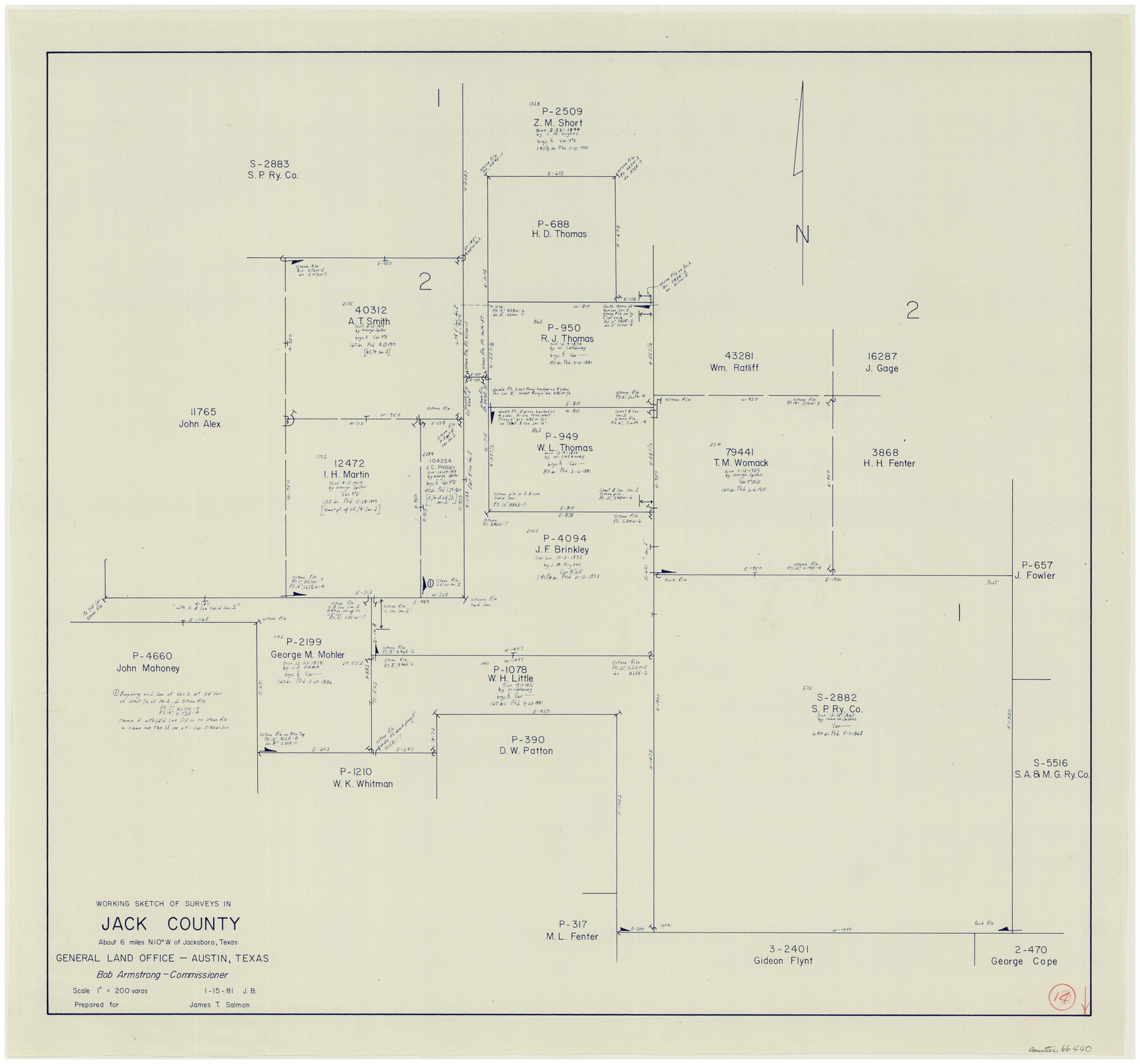
Jack County Working Sketch 14
-
Map/Doc
66440
-
Collection
General Map Collection
-
Object Dates
1/15/1981 (Creation Date)
-
People and Organizations
Jana Brod (Draftsman)
-
Counties
Jack
-
Subjects
Surveying Working Sketch
-
Height x Width
28.2 x 30.2 inches
71.6 x 76.7 cm
-
Scale
1" = 200 varas
Part of: General Map Collection
Andrews County Rolled Sketch 34

Print $20.00
- Digital $50.00
Andrews County Rolled Sketch 34
1955
Size 34.9 x 40.0 inches
Map/Doc 8913
Kleberg County Rolled Sketch 10-12

Print $20.00
- Digital $50.00
Kleberg County Rolled Sketch 10-12
1951
Size 38.8 x 34.9 inches
Map/Doc 9371
Brown County Sketch File 12a

Print $8.00
- Digital $50.00
Brown County Sketch File 12a
1870
Size 12.4 x 8.1 inches
Map/Doc 16604
Fractional Township No. 6 South Range No. 4 West of the Indian Meridian, Indian Territory

Print $20.00
- Digital $50.00
Fractional Township No. 6 South Range No. 4 West of the Indian Meridian, Indian Territory
1898
Size 19.2 x 24.4 inches
Map/Doc 75191
Hunt County Boundary File 11a

Print $15.00
- Digital $50.00
Hunt County Boundary File 11a
Size 11.1 x 8.9 inches
Map/Doc 55272
Colonial Texas. 1822 to 1834.

Print $20.00
- Digital $50.00
Colonial Texas. 1822 to 1834.
1897
Size 12.8 x 16.3 inches
Map/Doc 93410
Hockley County Rolled Sketch 3

Print $40.00
- Digital $50.00
Hockley County Rolled Sketch 3
Size 82.9 x 29.4 inches
Map/Doc 9173
Presidio County Working Sketch 118

Print $20.00
- Digital $50.00
Presidio County Working Sketch 118
1983
Size 47.4 x 41.6 inches
Map/Doc 71795
Map of Trinity Co.

Print $20.00
- Digital $50.00
Map of Trinity Co.
1896
Size 40.7 x 39.1 inches
Map/Doc 63079
Jefferson County Rolled Sketch 67

Print $20.00
- Digital $50.00
Jefferson County Rolled Sketch 67
2007
Size 21.1 x 23.6 inches
Map/Doc 93426
Sabine County Sketch File 7

Print $2.00
Sabine County Sketch File 7
1882
Size 8.6 x 12.7 inches
Map/Doc 35619
Padre Island National Seashore

Print $4.00
- Digital $50.00
Padre Island National Seashore
Size 16.0 x 22.3 inches
Map/Doc 60532
You may also like
Freestone County Boundary File 30b

Print $20.00
- Digital $50.00
Freestone County Boundary File 30b
Size 43.9 x 12.4 inches
Map/Doc 53598
The Pringle and Grieve Colony. November 1, 1843

Print $20.00
The Pringle and Grieve Colony. November 1, 1843
2020
Size 23.0 x 17.7 inches
Map/Doc 96371
Terrell County Working Sketch 6

Print $20.00
- Digital $50.00
Terrell County Working Sketch 6
1914
Size 15.7 x 21.9 inches
Map/Doc 62155
Section 8, Block B

Print $20.00
- Digital $50.00
Section 8, Block B
1951
Size 24.8 x 16.8 inches
Map/Doc 92275
Culberson County Sketch File 27a

Print $28.00
- Digital $50.00
Culberson County Sketch File 27a
Size 11.2 x 8.5 inches
Map/Doc 20266
Eastland County Working Sketch 59

Print $20.00
- Digital $50.00
Eastland County Working Sketch 59
1987
Size 19.7 x 37.9 inches
Map/Doc 68840
Bee County Sketch File 27

Print $8.00
- Digital $50.00
Bee County Sketch File 27
1886
Size 14.3 x 8.8 inches
Map/Doc 14331
Flight Mission No. CGI-1N, Frame 135, Cameron County

Print $20.00
- Digital $50.00
Flight Mission No. CGI-1N, Frame 135, Cameron County
1955
Size 17.2 x 18.7 inches
Map/Doc 84491
Crosby County Sketch File 10

Print $12.00
- Digital $50.00
Crosby County Sketch File 10
1887
Size 12.8 x 8.2 inches
Map/Doc 20011
Howard County Rolled Sketch 5

Print $20.00
- Digital $50.00
Howard County Rolled Sketch 5
Size 19.6 x 16.5 inches
Map/Doc 6234
Map of Coryell County

Print $20.00
- Digital $50.00
Map of Coryell County
1874
Size 22.4 x 26.8 inches
Map/Doc 3445
Gaines County Working Sketch 36

Print $20.00
- Digital $50.00
Gaines County Working Sketch 36
Size 23.5 x 36.7 inches
Map/Doc 69336