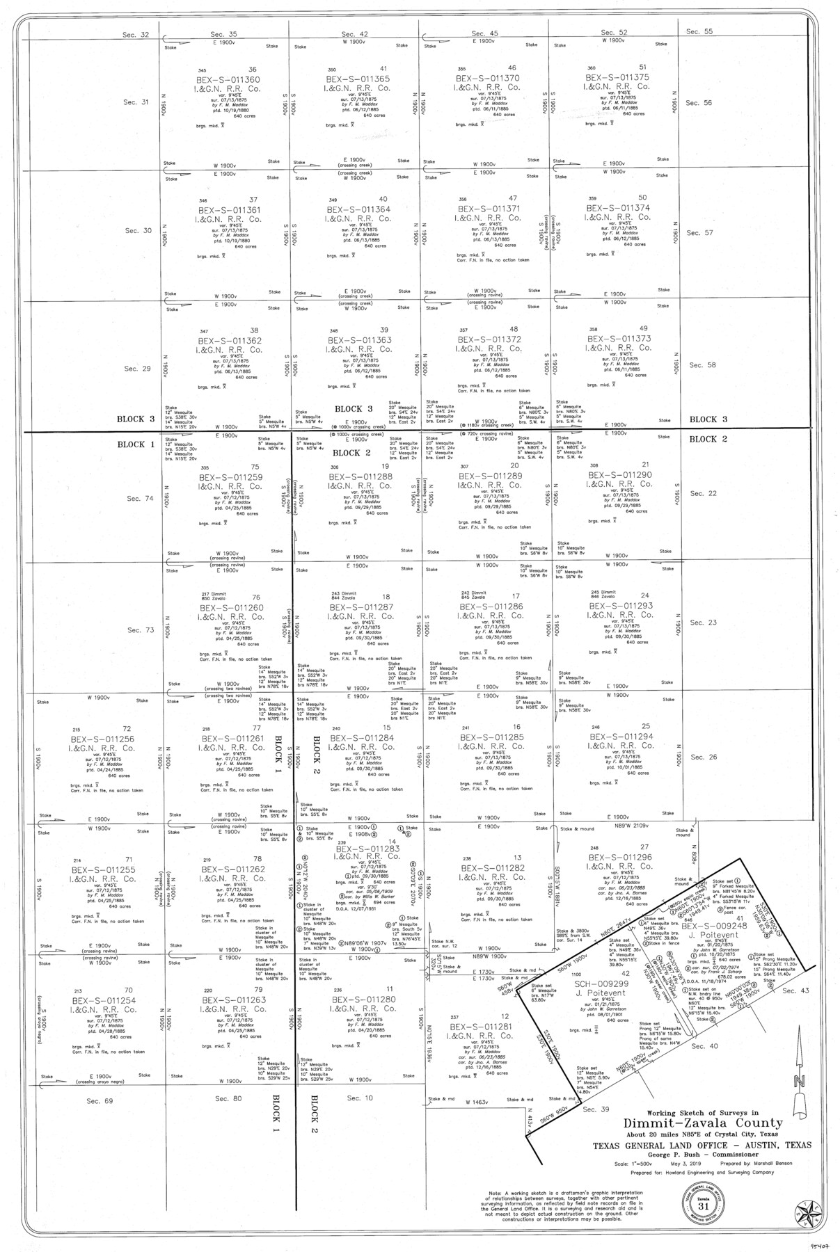
Zavala County Working Sketch 31
-
Map/Doc
95407
-
Collection
General Map Collection
-
Object Dates
5/3/2019 (Creation Date)
-
People and Organizations
Marshall Benson (Draftsman)
-
Counties
Dimmit Zavala
-
Subjects
Surveying Working Sketch
-
Height x Width
36.0 x 24.2 inches
91.4 x 61.5 cm
-
Medium
mylar, print
-
Scale
1" = 500 varas
Part of: General Map Collection
Coke County Rolled Sketch 3

Print $20.00
- Digital $50.00
Coke County Rolled Sketch 3
1947
Size 40.6 x 40.3 inches
Map/Doc 8623
[Sketch for Mineral Application 26501 - Sabine River, T. A. Oldhausen]
![2844, [Sketch for Mineral Application 26501 - Sabine River, T. A. Oldhausen], General Map Collection](https://historictexasmaps.com/wmedia_w700/maps/2844.tif.jpg)
Print $20.00
- Digital $50.00
[Sketch for Mineral Application 26501 - Sabine River, T. A. Oldhausen]
1931
Size 24.4 x 36.8 inches
Map/Doc 2844
Brewster County Working Sketch 113

Print $20.00
- Digital $50.00
Brewster County Working Sketch 113
1982
Size 29.4 x 38.2 inches
Map/Doc 67713
Atascosa County Working Sketch 21

Print $20.00
- Digital $50.00
Atascosa County Working Sketch 21
1954
Size 26.0 x 22.4 inches
Map/Doc 67217
Sterling County Working Sketch Graphic Index

Print $20.00
- Digital $50.00
Sterling County Working Sketch Graphic Index
1971
Size 45.5 x 36.3 inches
Map/Doc 76703
San Augustine County Rolled Sketch 3

Print $20.00
- Digital $50.00
San Augustine County Rolled Sketch 3
1969
Size 21.5 x 29.0 inches
Map/Doc 7555
Nueces County Rolled Sketch 43B

Print $20.00
- Digital $50.00
Nueces County Rolled Sketch 43B
Size 28.0 x 36.5 inches
Map/Doc 6885
Map of Schleicher County

Print $20.00
- Digital $50.00
Map of Schleicher County
1887
Size 21.4 x 30.1 inches
Map/Doc 4021
Map of Kendall County

Print $20.00
- Digital $50.00
Map of Kendall County
1899
Size 36.8 x 34.2 inches
Map/Doc 66887
Lamb County Sketch File 1 and 1a

Print $30.00
- Digital $50.00
Lamb County Sketch File 1 and 1a
Size 8.7 x 7.6 inches
Map/Doc 29337
South Sulphur River, Bonner Point Sheet

Print $20.00
- Digital $50.00
South Sulphur River, Bonner Point Sheet
1922
Size 32.9 x 35.7 inches
Map/Doc 65164
Gulf Coast of the United States, Key West to Rio Grande

Print $20.00
- Digital $50.00
Gulf Coast of the United States, Key West to Rio Grande
1892
Size 27.5 x 18.4 inches
Map/Doc 72672
You may also like
Kinney County Working Sketch 18

Print $40.00
- Digital $50.00
Kinney County Working Sketch 18
1948
Size 56.7 x 40.5 inches
Map/Doc 70200
Public Land on Mustang Island, Nueces County

Print $20.00
- Digital $50.00
Public Land on Mustang Island, Nueces County
1910
Size 17.0 x 17.5 inches
Map/Doc 1997
Sutton County Sketch File 42

Print $6.00
- Digital $50.00
Sutton County Sketch File 42
1940
Size 11.2 x 8.8 inches
Map/Doc 37509
Dietzgen "Federal" 986 Proportional Divider Drafting Tool

Dietzgen "Federal" 986 Proportional Divider Drafting Tool
Size 1.0 x 8.3 inches
Map/Doc 97307
Corpus Christi and Rio Grande Railway Company

Print $20.00
Corpus Christi and Rio Grande Railway Company
Size 14.6 x 24.0 inches
Map/Doc 95314
Terrell County Working Sketch 31

Print $20.00
- Digital $50.00
Terrell County Working Sketch 31
1945
Size 26.8 x 27.8 inches
Map/Doc 62123
Howard County Sketch File 13

Print $62.00
- Digital $50.00
Howard County Sketch File 13
1935
Size 15.0 x 13.3 inches
Map/Doc 26867
Ward County Boundary File 2

Print $4.00
- Digital $50.00
Ward County Boundary File 2
Size 11.1 x 8.9 inches
Map/Doc 59673
[Blocks N and B]
![90498, [Blocks N and B], Twichell Survey Records](https://historictexasmaps.com/wmedia_w700/maps/90498-1.tif.jpg)
Print $3.00
- Digital $50.00
[Blocks N and B]
Size 10.0 x 11.4 inches
Map/Doc 90498
[Blocks S3, T2, A, O5, and vicinity]
![92177, [Blocks S3, T2, A, O5, and vicinity], Twichell Survey Records](https://historictexasmaps.com/wmedia_w700/maps/92177-1.tif.jpg)
Print $20.00
- Digital $50.00
[Blocks S3, T2, A, O5, and vicinity]
Size 22.1 x 21.2 inches
Map/Doc 92177
Lavaca County Sketch File 22

Print $28.00
- Digital $50.00
Lavaca County Sketch File 22
1959
Size 14.2 x 8.7 inches
Map/Doc 29654
Hall County Sketch File 7

Print $20.00
- Digital $50.00
Hall County Sketch File 7
1890
Size 12.0 x 22.4 inches
Map/Doc 11603