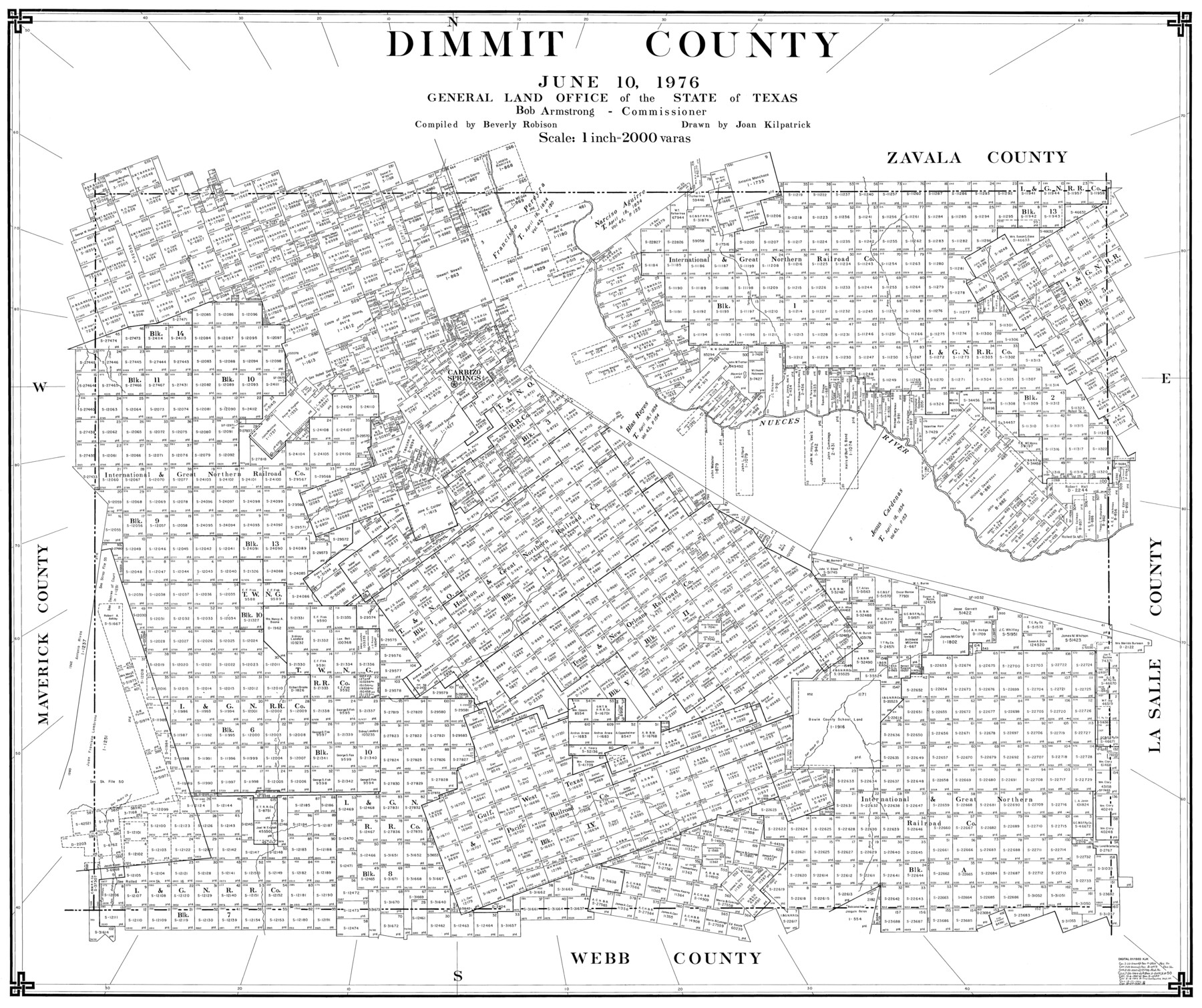
Dimmit County
-
Map/Doc
77265
-
Collection
General Map Collection
-
Object Dates
6/10/1976 (Creation Date)
-
People and Organizations
Beverly Robison (Compiler)
Joan Kilpatrick (Draftsman)
-
Counties
Dimmit
-
Subjects
County
-
Height x Width
42.2 x 48.9 inches
107.2 x 124.2 cm
-
Scale
1" = 2000 varas
Part of: General Map Collection
Howard County Rolled Sketch 5

Print $20.00
- Digital $50.00
Howard County Rolled Sketch 5
Size 19.6 x 16.5 inches
Map/Doc 6234
The Dividing Link - Mexico & Central America

The Dividing Link - Mexico & Central America
Size 20.5 x 31.2 inches
Map/Doc 95941
Crosby County Sketch File 32

Print $20.00
- Digital $50.00
Crosby County Sketch File 32
1938
Size 23.2 x 31.8 inches
Map/Doc 11258
Map of the Northern Part of Houston District

Print $20.00
- Digital $50.00
Map of the Northern Part of Houston District
1849
Size 26.4 x 26.7 inches
Map/Doc 3223
Ector County Sketch File 12

Print $12.00
- Digital $50.00
Ector County Sketch File 12
1956
Size 11.4 x 9.0 inches
Map/Doc 21645
Orange County Working Sketch 11

Print $20.00
- Digital $50.00
Orange County Working Sketch 11
1922
Size 11.9 x 14.7 inches
Map/Doc 71343
Palo Pinto County Rolled Sketch 2

Print $20.00
- Digital $50.00
Palo Pinto County Rolled Sketch 2
1917
Size 37.5 x 43.8 inches
Map/Doc 9669
Morris County Rolled Sketch 2A

Print $20.00
- Digital $50.00
Morris County Rolled Sketch 2A
Size 24.2 x 19.1 inches
Map/Doc 10249
Burleson County Sketch File 7

Print $40.00
- Digital $50.00
Burleson County Sketch File 7
1935
Size 17.0 x 14.5 inches
Map/Doc 16653
Wilson County Working Sketch 8

Print $20.00
- Digital $50.00
Wilson County Working Sketch 8
1975
Size 36.5 x 31.9 inches
Map/Doc 72588
Edwards County Working Sketch Graphic Index - east part - sheet 1

Print $40.00
- Digital $50.00
Edwards County Working Sketch Graphic Index - east part - sheet 1
1975
Size 54.8 x 39.9 inches
Map/Doc 76533
Plan de la Villa de Austin

Print $20.00
- Digital $50.00
Plan de la Villa de Austin
1828
Size 18.5 x 12.5 inches
Map/Doc 94116
You may also like
[Galveston, Harrisburg & San Antonio Railroad from Cuero to Stockdale]
![64187, [Galveston, Harrisburg & San Antonio Railroad from Cuero to Stockdale], General Map Collection](https://historictexasmaps.com/wmedia_w700/maps/64187.tif.jpg)
Print $20.00
- Digital $50.00
[Galveston, Harrisburg & San Antonio Railroad from Cuero to Stockdale]
1906
Size 13.3 x 32.9 inches
Map/Doc 64187
Approaches to Galveston Bay

Print $40.00
- Digital $50.00
Approaches to Galveston Bay
1973
Size 49.8 x 35.6 inches
Map/Doc 69882
Rockwall County Boundary File 7

Print $4.00
- Digital $50.00
Rockwall County Boundary File 7
Size 11.5 x 8.8 inches
Map/Doc 58426
Rio Grande, North Extension McAllen Sheet

Print $20.00
- Digital $50.00
Rio Grande, North Extension McAllen Sheet
1937
Size 18.5 x 42.1 inches
Map/Doc 65108
Map showing lands acquired for reservoir purposes in connection with Lake Worth and the boundary of territory annexed to the City of Fort Worth, Texas

Print $40.00
- Digital $50.00
Map showing lands acquired for reservoir purposes in connection with Lake Worth and the boundary of territory annexed to the City of Fort Worth, Texas
Size 46.6 x 59.6 inches
Map/Doc 62210
[Surveys on Galveston and East Bay]
![248, [Surveys on Galveston and East Bay], General Map Collection](https://historictexasmaps.com/wmedia_w700/maps/248.tif.jpg)
Print $2.00
- Digital $50.00
[Surveys on Galveston and East Bay]
1846
Size 8.8 x 7.9 inches
Map/Doc 248
Austin, State Capital of Texas

Print $20.00
Austin, State Capital of Texas
1887
Size 27.5 x 40.0 inches
Map/Doc 89218
Nueces County Rolled Sketch 3
Print $20.00
- Digital $50.00
Nueces County Rolled Sketch 3
1907
Size 17.3 x 34.2 inches
Map/Doc 6866

Carte du Mexique et de la Floride des Terres Angloises et des Isles Antilles du cours et des environs de la Riviere de Mississipi

Print $20.00
- Digital $50.00
Carte du Mexique et de la Floride des Terres Angloises et des Isles Antilles du cours et des environs de la Riviere de Mississipi
1703
Size 19.0 x 25.8 inches
Map/Doc 96519
The Republic County of Fayette. Created, December 14, 1837

Print $20.00
The Republic County of Fayette. Created, December 14, 1837
2020
Size 14.7 x 21.7 inches
Map/Doc 96131
Hall County Sketch File 6

Print $20.00
- Digital $50.00
Hall County Sketch File 6
1885
Size 28.2 x 37.9 inches
Map/Doc 10473