Knox County Sketch File 24
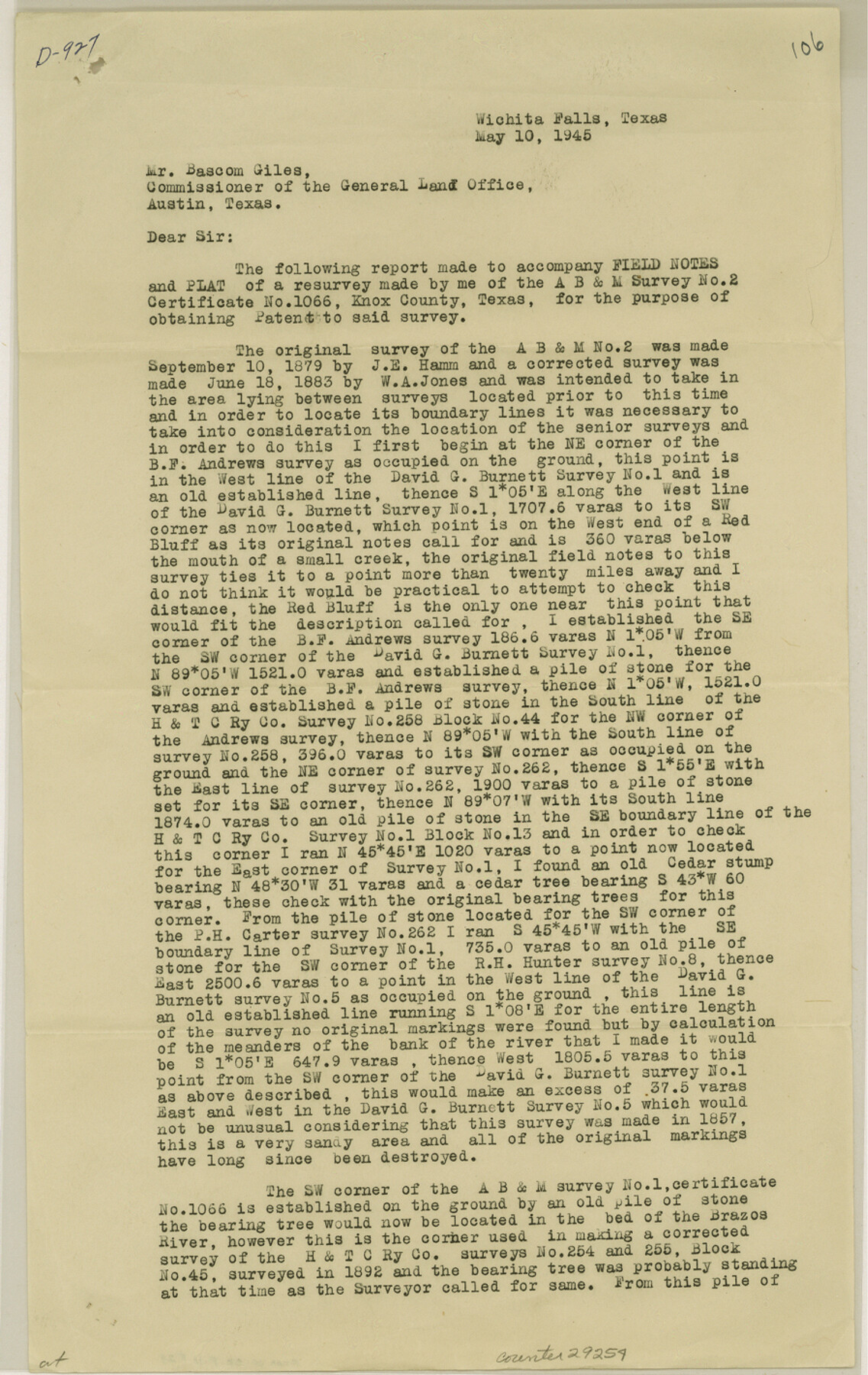
[Report of survey of section 2, A. B. & M., southwest from Benjamin]
-
Map/Doc
29254
-
Collection
General Map Collection
-
Object Dates
1945/5/22 (File Date)
1945/5/10 (Creation Date)
-
People and Organizations
J.E. Hamm (Surveyor/Engineer)
W.A. Jones (Surveyor/Engineer)
Ross Corlett (Surveyor/Engineer)
William Cloud (Surveyor/Engineer)
-
Counties
Knox
-
Subjects
Surveying Sketch File
-
Height x Width
14.2 x 9.0 inches
36.1 x 22.9 cm
-
Medium
paper, print
-
Comments
See Knox County Rolled Sketch 18 (6558) for sketch.
-
Features
Red Bluff
Salt Fork of the Brazos River
Related maps
Knox County Rolled Sketch 18

Print $20.00
- Digital $50.00
Knox County Rolled Sketch 18
1945
Size 23.1 x 29.5 inches
Map/Doc 6558
Part of: General Map Collection
A Comprehensive Atlas Geographical, Historical & Commercial

A Comprehensive Atlas Geographical, Historical & Commercial
Size 13.0 x 10.7 inches
Map/Doc 95959
Wichita County Sketch File A

Print $4.00
- Digital $50.00
Wichita County Sketch File A
1861
Size 7.8 x 10.3 inches
Map/Doc 40036
Colorado County Rolled Sketch 1

Print $20.00
- Digital $50.00
Colorado County Rolled Sketch 1
1940
Size 37.6 x 35.5 inches
Map/Doc 8640
Hemphill County Rolled Sketch 18

Print $20.00
- Digital $50.00
Hemphill County Rolled Sketch 18
Size 23.6 x 35.0 inches
Map/Doc 6200
Cherokee County Sketch File 26

Print $4.00
- Digital $50.00
Cherokee County Sketch File 26
1852
Size 8.1 x 8.2 inches
Map/Doc 18169
Duval County Working Sketch 55

Print $20.00
- Digital $50.00
Duval County Working Sketch 55
1936
Size 25.7 x 21.6 inches
Map/Doc 68779
Zapata County Sketch File 1

Print $20.00
- Digital $50.00
Zapata County Sketch File 1
1875
Size 30.5 x 21.4 inches
Map/Doc 12717
Aransas County Sketch File 29

Print $24.00
- Digital $50.00
Aransas County Sketch File 29
Size 7.8 x 8.1 inches
Map/Doc 13234
Harris County Rolled Sketch T2

Print $20.00
- Digital $50.00
Harris County Rolled Sketch T2
1916
Size 26.8 x 23.2 inches
Map/Doc 6145
Liberty County Rolled Sketch I

Print $20.00
- Digital $50.00
Liberty County Rolled Sketch I
1944
Size 38.1 x 38.1 inches
Map/Doc 10642
Edwards County Sketch File 5

Print $5.00
- Digital $50.00
Edwards County Sketch File 5
Size 9.0 x 3.9 inches
Map/Doc 21682
Nacogdoches County Working Sketch 5

Print $20.00
- Digital $50.00
Nacogdoches County Working Sketch 5
1949
Size 22.9 x 22.1 inches
Map/Doc 71221
You may also like
Dickens County Rolled Sketch 9

Print $20.00
- Digital $50.00
Dickens County Rolled Sketch 9
1954
Size 41.0 x 30.3 inches
Map/Doc 5708
Sylvan Sanders Survey Section 3, Block E

Print $20.00
- Digital $50.00
Sylvan Sanders Survey Section 3, Block E
1952
Size 37.4 x 24.2 inches
Map/Doc 92741
Section across Valley Bench and Terraces - South Side of Red River - Big Bend Area

Print $20.00
Section across Valley Bench and Terraces - South Side of Red River - Big Bend Area
1921
Size 10.2 x 34.8 inches
Map/Doc 79750
[Map of Lubbock showing Sears Addition, Sunset Place, Loma Linda Place, University Place, Webb Addition, Ellwood Place, Del Mar Addition and Del Mar Annex]
![92729, [Map of Lubbock showing Sears Addition, Sunset Place, Loma Linda Place, University Place, Webb Addition, Ellwood Place, Del Mar Addition and Del Mar Annex], Twichell Survey Records](https://historictexasmaps.com/wmedia_w700/maps/92729-1.tif.jpg)
Print $20.00
- Digital $50.00
[Map of Lubbock showing Sears Addition, Sunset Place, Loma Linda Place, University Place, Webb Addition, Ellwood Place, Del Mar Addition and Del Mar Annex]
Size 30.8 x 30.8 inches
Map/Doc 92729
Liberty County Rolled Sketch A

Print $20.00
- Digital $50.00
Liberty County Rolled Sketch A
1919
Size 31.8 x 35.9 inches
Map/Doc 9569
Motley County Sketch File B2 (N)

Print $8.00
- Digital $50.00
Motley County Sketch File B2 (N)
Size 8.6 x 6.1 inches
Map/Doc 31970
Mitchell's New Intermediate Geography (Louisiana Edition)

Print $819.00
- Digital $50.00
Mitchell's New Intermediate Geography (Louisiana Edition)
1885
Size 12.5 x 10.0 inches
Map/Doc 93509
Dickens County

Print $20.00
- Digital $50.00
Dickens County
1891
Size 25.7 x 20.6 inches
Map/Doc 3488
Current Miscellaneous File 42

Print $4.00
- Digital $50.00
Current Miscellaneous File 42
Size 11.2 x 8.7 inches
Map/Doc 73981
Maps of Gulf Intracoastal Waterway, Texas - Sabine River to the Rio Grande and connecting waterways including ship channels

Print $20.00
- Digital $50.00
Maps of Gulf Intracoastal Waterway, Texas - Sabine River to the Rio Grande and connecting waterways including ship channels
1966
Size 14.5 x 22.2 inches
Map/Doc 61915
Sketch showing progress of topographical work Laguna Madre and vicinity from Rainey Is. to Baffins Bay, Coast of Texas Sect. IX [and accompanying letter]
![72961, Sketch showing progress of topographical work Laguna Madre and vicinity from Rainey Is. to Baffins Bay, Coast of Texas Sect. IX [and accompanying letter], General Map Collection](https://historictexasmaps.com/wmedia_w700/maps/72961.tif.jpg)
Print $2.00
- Digital $50.00
Sketch showing progress of topographical work Laguna Madre and vicinity from Rainey Is. to Baffins Bay, Coast of Texas Sect. IX [and accompanying letter]
Size 11.1 x 8.7 inches
Map/Doc 72961
Tyler County Sketch File 6-3

Print $20.00
- Digital $50.00
Tyler County Sketch File 6-3
1861
Size 20.0 x 22.1 inches
Map/Doc 12499