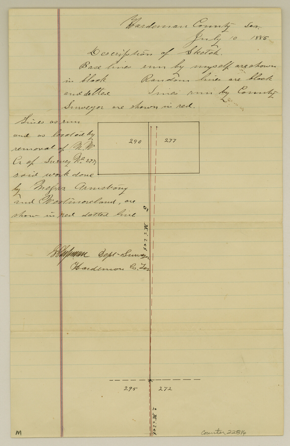
Foard County Sketch File 13
[Sketch of baselines in Block A]
-
Map/Doc
22816
-
Collection
General Map Collection
-
Object Dates
1885/7/10 (Creation Date)
-
People and Organizations
G. Chipman (Surveyor/Engineer)
Armstrong (Surveyor/Engineer)
Westmoreland (Surveyor/Engineer)
-
Counties
Foard Hardeman
-
Subjects
Surveying Sketch File
-
Height x Width
13.0 x 8.5 inches
33.0 x 21.6 cm
-
Medium
paper, manuscript
Part of: General Map Collection
Ward County Working Sketch 55

Print $20.00
- Digital $50.00
Ward County Working Sketch 55
1986
Size 30.0 x 36.8 inches
Map/Doc 72361
Map of Nacogdoches County

Print $20.00
- Digital $50.00
Map of Nacogdoches County
1881
Size 25.2 x 20.7 inches
Map/Doc 4601
Sabine County

Print $20.00
- Digital $50.00
Sabine County
1920
Size 44.6 x 35.1 inches
Map/Doc 16805
Official Map of the City of Dallas and Suburbs

Print $20.00
- Digital $50.00
Official Map of the City of Dallas and Suburbs
1891
Size 37.8 x 30.1 inches
Map/Doc 3211
La Salle County Rolled Sketch 4

Print $20.00
- Digital $50.00
La Salle County Rolled Sketch 4
1937
Size 20.9 x 27.5 inches
Map/Doc 6569
Tarrant's Key & Guide to Dallas

Print $20.00
- Digital $50.00
Tarrant's Key & Guide to Dallas
1925
Size 25.5 x 24.9 inches
Map/Doc 96975
Terrell County Working Sketch 64

Print $20.00
- Digital $50.00
Terrell County Working Sketch 64
1971
Size 29.3 x 27.7 inches
Map/Doc 69585
Kenedy County Rolled Sketch 11

Print $20.00
- Digital $50.00
Kenedy County Rolled Sketch 11
1938
Size 40.5 x 30.2 inches
Map/Doc 6471
Lavaca County Sketch File 6

Print $2.00
- Digital $50.00
Lavaca County Sketch File 6
Size 7.3 x 3.2 inches
Map/Doc 29641
Red River County

Print $20.00
- Digital $50.00
Red River County
1896
Size 24.3 x 21.5 inches
Map/Doc 3977
St. Louis, Brownsville & Mexico Railway Location map from Mile 40 to Mile 60

Print $40.00
- Digital $50.00
St. Louis, Brownsville & Mexico Railway Location map from Mile 40 to Mile 60
1905
Size 19.6 x 74.9 inches
Map/Doc 64079
Wheeler County

Print $20.00
- Digital $50.00
Wheeler County
1899
Size 42.2 x 37.9 inches
Map/Doc 95672
You may also like
Flight Mission No. BRA-7M, Frame 133, Jefferson County

Print $20.00
- Digital $50.00
Flight Mission No. BRA-7M, Frame 133, Jefferson County
1953
Size 18.6 x 22.3 inches
Map/Doc 85527
General Highway Map, Lavaca County, Texas

Print $20.00
General Highway Map, Lavaca County, Texas
1961
Size 24.6 x 18.1 inches
Map/Doc 79566
Hidalgo County
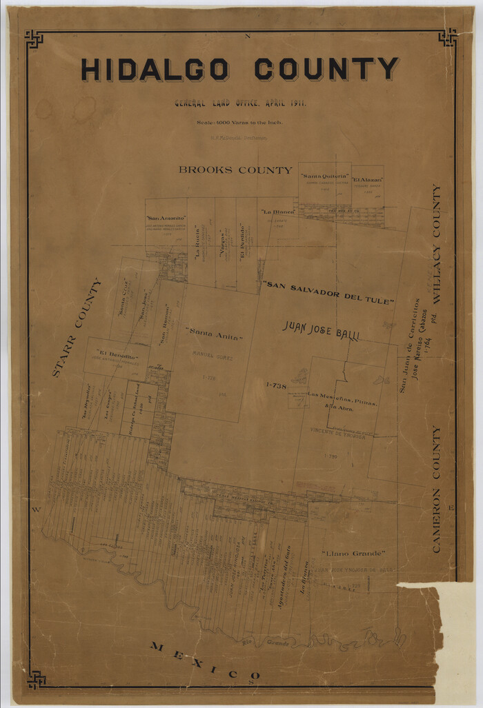
Print $20.00
- Digital $50.00
Hidalgo County
1911
Size 42.1 x 28.7 inches
Map/Doc 16850
Flight Mission No. CRE-2R, Frame 152, Jackson County

Print $20.00
- Digital $50.00
Flight Mission No. CRE-2R, Frame 152, Jackson County
1956
Size 16.3 x 16.1 inches
Map/Doc 85363
Polk County Sketch File 4

Print $4.00
- Digital $50.00
Polk County Sketch File 4
1859
Size 10.2 x 8.0 inches
Map/Doc 34126
Sutton County Working Sketch 58

Print $40.00
- Digital $50.00
Sutton County Working Sketch 58
1958
Size 57.3 x 37.5 inches
Map/Doc 62401
Potter County Working Sketch 8

Print $40.00
- Digital $50.00
Potter County Working Sketch 8
1961
Size 68.7 x 37.2 inches
Map/Doc 71668
Brazoria County Sketch File 26

Print $40.00
- Digital $50.00
Brazoria County Sketch File 26
Size 13.6 x 13.6 inches
Map/Doc 15028
Coast Chart No. 212 - From Latitude 26° 33' to the Rio Grande Texas

Print $20.00
- Digital $50.00
Coast Chart No. 212 - From Latitude 26° 33' to the Rio Grande Texas
1886
Size 18.3 x 27.4 inches
Map/Doc 72825
Martin County Rolled Sketch 10

Print $20.00
- Digital $50.00
Martin County Rolled Sketch 10
1994
Size 18.4 x 24.2 inches
Map/Doc 6670
Duval County Working Sketch 5
Print $40.00
- Digital $50.00
Duval County Working Sketch 5
1933
Size 43.2 x 54.2 inches
Map/Doc 68718
Trinity River, Watershed

Print $20.00
- Digital $50.00
Trinity River, Watershed
1925
Size 46.9 x 40.5 inches
Map/Doc 65255