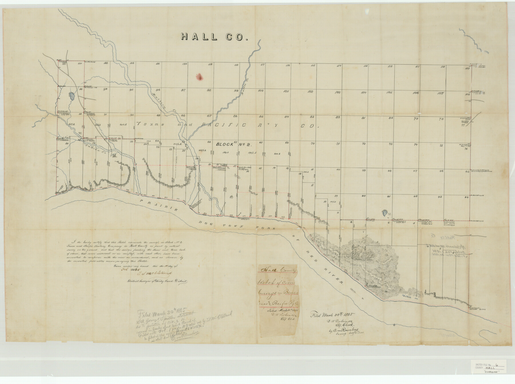
Hall County Sketch File 6
McClelland's Sk. of Blk. 1
-
Map/Doc
10473
-
Collection
General Map Collection
-
Object Dates
1885/2/1 (Creation Date)
1885/3/30 (File Date)
-
People and Organizations
T.S. McClelland (Surveyor/Engineer)
E. von Rosenberg (Draftsman)
-
Counties
Hall Briscoe
-
Subjects
Surveying Sketch File
-
Height x Width
28.2 x 37.9 inches
71.6 x 96.3 cm
-
Medium
paper, manuscript
-
Features
Battle Creek
Mulberry Creek
Timber Creek
Indian Creek
Prairie Dog Town Fork of Red River
Deep Lake
Part of: General Map Collection
Republic of Texas and boundaries as claimed by Texas from Decr. 19th, 1836 to Novr. 26th, 1850

Print $20.00
- Digital $50.00
Republic of Texas and boundaries as claimed by Texas from Decr. 19th, 1836 to Novr. 26th, 1850
1897
Size 20.7 x 19.3 inches
Map/Doc 93411
Jefferson County Rolled Sketch 8A

Print $20.00
- Digital $50.00
Jefferson County Rolled Sketch 8A
1928
Size 35.6 x 46.3 inches
Map/Doc 76030
Flight Mission No. CGI-3N, Frame 75, Cameron County

Print $20.00
- Digital $50.00
Flight Mission No. CGI-3N, Frame 75, Cameron County
1954
Size 18.6 x 22.2 inches
Map/Doc 84569
[Surveys along Rabb's Creek]
![154, [Surveys along Rabb's Creek], General Map Collection](https://historictexasmaps.com/wmedia_w700/maps/154.tif.jpg)
Print $2.00
- Digital $50.00
[Surveys along Rabb's Creek]
1841
Size 8.7 x 11.0 inches
Map/Doc 154
Floyd County Rolled Sketch 9

Print $323.00
- Digital $50.00
Floyd County Rolled Sketch 9
1953
Size 10.0 x 15.7 inches
Map/Doc 44564
Real County Rolled Sketch 18

Print $20.00
- Digital $50.00
Real County Rolled Sketch 18
Size 22.0 x 28.0 inches
Map/Doc 7463
Schleicher County Working Sketch 24

Print $20.00
- Digital $50.00
Schleicher County Working Sketch 24
1955
Size 42.6 x 43.3 inches
Map/Doc 63826
Houston County Rolled Sketch 7

Print $40.00
- Digital $50.00
Houston County Rolled Sketch 7
Size 43.2 x 50.1 inches
Map/Doc 9183
Crockett County Sketch File H

Print $26.00
- Digital $50.00
Crockett County Sketch File H
1920
Size 14.4 x 9.0 inches
Map/Doc 19638
Map of Concho County

Print $20.00
- Digital $50.00
Map of Concho County
1897
Size 46.9 x 38.4 inches
Map/Doc 4919
Dimmit County Working Sketch 40

Print $40.00
- Digital $50.00
Dimmit County Working Sketch 40
1968
Size 42.9 x 59.0 inches
Map/Doc 68701
Reeves County Sketch File 23a and 23b

Print $4.00
- Digital $50.00
Reeves County Sketch File 23a and 23b
1985
Size 14.9 x 8.7 inches
Map/Doc 35222
You may also like
Haskell County Working Sketch 14

Print $20.00
- Digital $50.00
Haskell County Working Sketch 14
1983
Size 34.2 x 40.7 inches
Map/Doc 66072
Railroad and County Map of Texas

Print $20.00
Railroad and County Map of Texas
1903
Size 33.5 x 37.4 inches
Map/Doc 76224
Lipscomb County Boundary File 10

Print $18.00
- Digital $50.00
Lipscomb County Boundary File 10
Size 11.2 x 8.6 inches
Map/Doc 56338
Current Miscellaneous File 25

Print $24.00
- Digital $50.00
Current Miscellaneous File 25
1953
Size 10.6 x 8.2 inches
Map/Doc 73897
Leon County Rolled Sketch 16

Print $40.00
- Digital $50.00
Leon County Rolled Sketch 16
1981
Size 42.8 x 65.3 inches
Map/Doc 9433
General Highway Map. Detail of Cities and Towns in Bowie County, Texas

Print $20.00
General Highway Map. Detail of Cities and Towns in Bowie County, Texas
1961
Size 18.0 x 24.8 inches
Map/Doc 79381
United States - Gulf Coast - Galveston to Rio Grande

Print $20.00
- Digital $50.00
United States - Gulf Coast - Galveston to Rio Grande
1941
Size 27.2 x 18.2 inches
Map/Doc 72753
La Salle County Working Sketch 48

Print $20.00
- Digital $50.00
La Salle County Working Sketch 48
1983
Size 26.2 x 36.0 inches
Map/Doc 70349
[Reconnaissance report of Lieut. Scariott around Laguna del Madre and up to Fort San Saba]
![73006, [Reconnaissance report of Lieut. Scariott around Laguna del Madre and up to Fort San Saba], General Map Collection](https://historictexasmaps.com/wmedia_w700/maps/73006.tif.jpg)
Print $20.00
- Digital $50.00
[Reconnaissance report of Lieut. Scariott around Laguna del Madre and up to Fort San Saba]
Size 25.2 x 18.2 inches
Map/Doc 73006
Uvalde County Sketch File 13

Print $20.00
- Digital $50.00
Uvalde County Sketch File 13
Size 14.3 x 29.1 inches
Map/Doc 12528
Jefferson County Working Sketch 36

Print $40.00
- Digital $50.00
Jefferson County Working Sketch 36
1982
Size 69.1 x 33.2 inches
Map/Doc 66580
Burleson County Working Sketch 7

Print $20.00
- Digital $50.00
Burleson County Working Sketch 7
1980
Size 15.2 x 11.4 inches
Map/Doc 67726