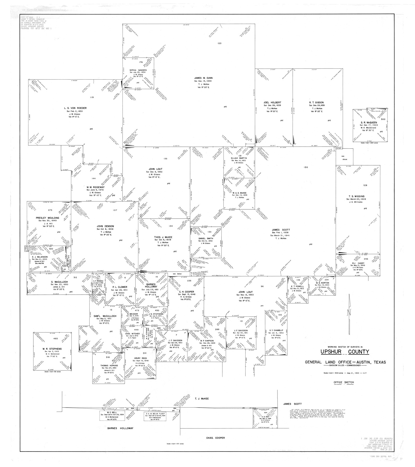
Upshur County Rolled Sketch 1
Working sketch of surveys in Upshur County [in east part of Upshur County]
-
Map/Doc
10298
-
Collection
General Map Collection
-
Object Dates
1953/8/21 (File Date)
1953/4/21 (Creation Date)
-
Counties
Upshur
-
Subjects
Surveying Rolled Sketch
-
Height x Width
50.2 x 44.7 inches
127.5 x 113.5 cm
-
Scale
1" = 400 varas
Part of: General Map Collection
Flight Mission No. DQO-6K, Frame 23, Galveston County

Print $20.00
- Digital $50.00
Flight Mission No. DQO-6K, Frame 23, Galveston County
1952
Size 18.8 x 22.5 inches
Map/Doc 85096
Brooks County Working Sketch 18

Print $20.00
- Digital $50.00
Brooks County Working Sketch 18
1981
Size 20.6 x 32.4 inches
Map/Doc 67802
Flight Mission No. BRA-16M, Frame 123, Jefferson County

Print $20.00
- Digital $50.00
Flight Mission No. BRA-16M, Frame 123, Jefferson County
1953
Size 18.6 x 22.5 inches
Map/Doc 85733
Duval County Sketch File 36b

Print $60.00
- Digital $50.00
Duval County Sketch File 36b
1935
Size 28.4 x 23.3 inches
Map/Doc 11393
Sutton County Sketch File F

Print $18.00
- Digital $50.00
Sutton County Sketch File F
1906
Size 14.1 x 8.7 inches
Map/Doc 37391
Lampasas County Sketch File 6

Print $4.00
- Digital $50.00
Lampasas County Sketch File 6
1871
Size 8.0 x 6.8 inches
Map/Doc 29400
Ellis County Boundary File 6

Print $22.00
- Digital $50.00
Ellis County Boundary File 6
Size 8.6 x 6.0 inches
Map/Doc 52992
Nueces County NRC Article 33.136 Location Key Sheet

Print $20.00
- Digital $50.00
Nueces County NRC Article 33.136 Location Key Sheet
1975
Size 27.5 x 23.0 inches
Map/Doc 88589
Flight Mission No. DQO-8K, Frame 134, Galveston County

Print $20.00
- Digital $50.00
Flight Mission No. DQO-8K, Frame 134, Galveston County
1952
Size 18.7 x 22.3 inches
Map/Doc 85199
Wichita County Sketch File 1

Print $22.00
- Digital $50.00
Wichita County Sketch File 1
1856
Size 13.5 x 16.8 inches
Map/Doc 40028
Tarrant County Sketch File 21

Print $4.00
- Digital $50.00
Tarrant County Sketch File 21
Size 12.5 x 8.4 inches
Map/Doc 37725
Walker County Working Sketch 13

Print $20.00
- Digital $50.00
Walker County Working Sketch 13
1950
Size 18.0 x 16.6 inches
Map/Doc 72293
You may also like
Clay County Working Sketch 8

Print $20.00
- Digital $50.00
Clay County Working Sketch 8
1937
Size 23.1 x 22.0 inches
Map/Doc 68031
Grayson County Boundary File 3

Print $8.00
- Digital $50.00
Grayson County Boundary File 3
Size 12.8 x 7.9 inches
Map/Doc 53941
Kimble County Sketch File 28

Print $20.00
- Digital $50.00
Kimble County Sketch File 28
Size 23.3 x 17.8 inches
Map/Doc 11927
Sterling County Rolled Sketch 8

Print $20.00
- Digital $50.00
Sterling County Rolled Sketch 8
1884
Size 27.9 x 31.9 inches
Map/Doc 7844
Dimmit County Sketch File 21

Print $16.00
- Digital $50.00
Dimmit County Sketch File 21
1898
Size 14.4 x 8.8 inches
Map/Doc 21115
Shelby County Rolled Sketch 20

Print $20.00
- Digital $50.00
Shelby County Rolled Sketch 20
1983
Size 24.7 x 37.2 inches
Map/Doc 7785

Aransas County Sketch File 31

Print $46.00
- Digital $50.00
Aransas County Sketch File 31
1919
Size 14.2 x 8.7 inches
Map/Doc 13274
Bosque County Sketch File 19

Print $4.00
- Digital $50.00
Bosque County Sketch File 19
1863
Size 12.9 x 6.2 inches
Map/Doc 14794
Fannin County Sketch File 18

Print $20.00
- Digital $50.00
Fannin County Sketch File 18
1879
Size 16.7 x 22.2 inches
Map/Doc 11472
Parker County Sketch File 30

Print $4.00
- Digital $50.00
Parker County Sketch File 30
Size 6.4 x 7.0 inches
Map/Doc 33570
Kimble County

Print $40.00
- Digital $50.00
Kimble County
1930
Size 43.8 x 49.2 inches
Map/Doc 73207