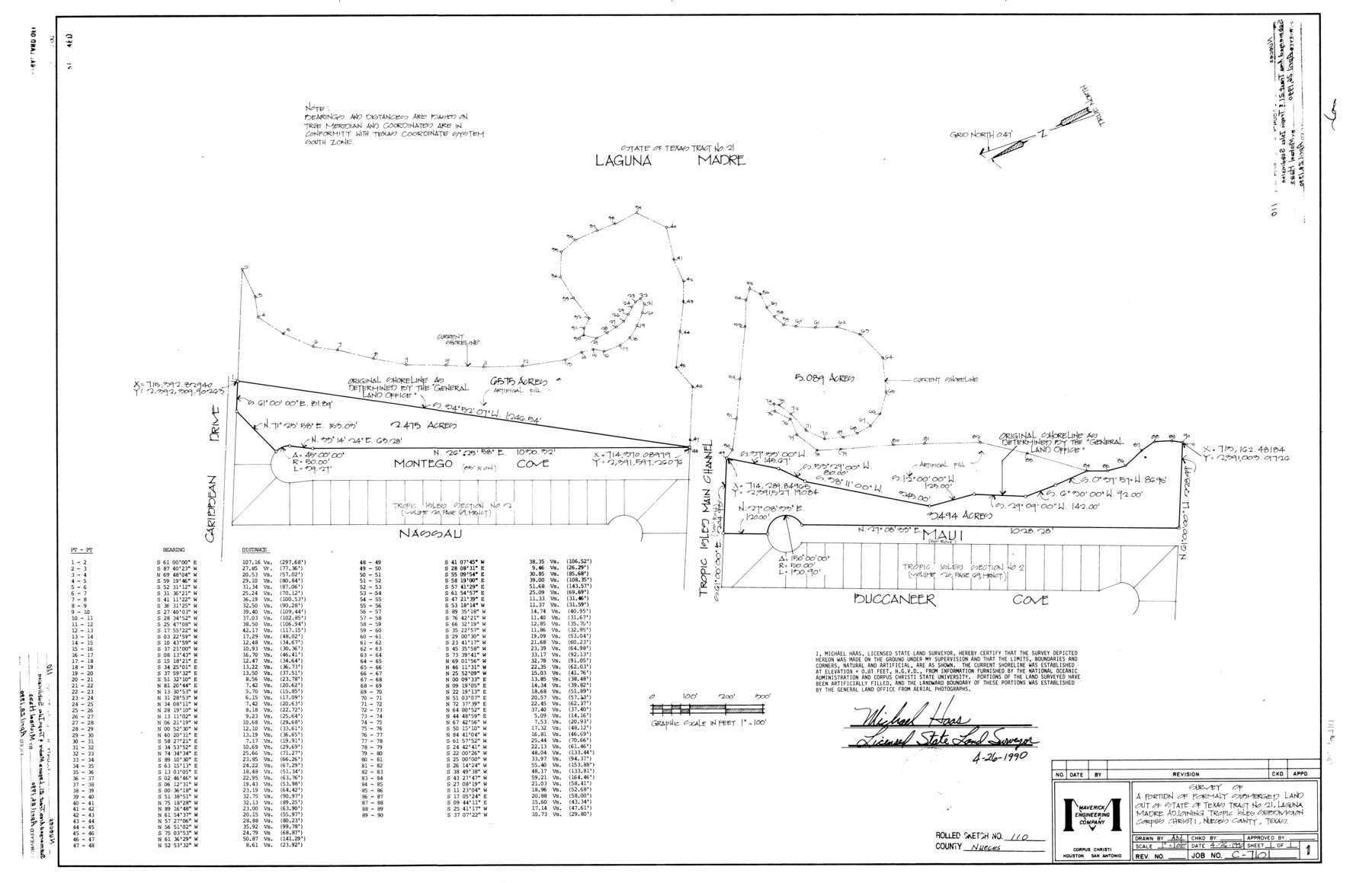
Nueces County Rolled Sketch 110
Survey of a portion of formerly submerged land out of State of Texas tract no. 21, Laguna Madre adjoining Tropic Isles subdivision, Corpus Christi, Nueces County, Texas
-
Map/Doc
7117
-
Collection
General Map Collection
-
Object Dates
1990/4/26 (Creation Date)
1990/4/28 (File Date)
-
People and Organizations
Michael Haas (Surveyor/Engineer)
-
Counties
Nueces
-
Subjects
Surveying Rolled Sketch
-
Height x Width
24.1 x 37.5 inches
61.2 x 95.3 cm
-
Medium
mylar, print
-
Scale
1" = 100 feet
Part of: General Map Collection
Kaufman County

Print $20.00
- Digital $50.00
Kaufman County
1871
Size 22.3 x 15.0 inches
Map/Doc 3750
Archer County Working Sketch 1

Print $20.00
- Digital $50.00
Archer County Working Sketch 1
Size 42.4 x 42.0 inches
Map/Doc 67141
Williamson County

Print $40.00
- Digital $50.00
Williamson County
1888
Size 39.3 x 57.1 inches
Map/Doc 16929

Tarrant County Sketch File 4

Print $4.00
- Digital $50.00
Tarrant County Sketch File 4
1856
Size 11.8 x 8.9 inches
Map/Doc 37678
Burleson County Working Sketch 20

Print $20.00
- Digital $50.00
Burleson County Working Sketch 20
1980
Size 19.5 x 16.6 inches
Map/Doc 67739
Potter County

Print $20.00
- Digital $50.00
Potter County
1960
Size 40.0 x 32.3 inches
Map/Doc 77397
Garza County Sketch File 4

Print $6.00
- Digital $50.00
Garza County Sketch File 4
1883
Size 12.6 x 11.0 inches
Map/Doc 24046
Map Exhibiting the line of the Southern Trans-Continental R.R. from Marshall to Texarkana from Texarkana to Forth Worth

Print $20.00
- Digital $50.00
Map Exhibiting the line of the Southern Trans-Continental R.R. from Marshall to Texarkana from Texarkana to Forth Worth
1872
Size 24.6 x 47.8 inches
Map/Doc 64241
Leon County Rolled Sketch 19

Print $20.00
- Digital $50.00
Leon County Rolled Sketch 19
1982
Size 23.9 x 37.4 inches
Map/Doc 6605
Zavala County Working Sketch 26

Print $20.00
- Digital $50.00
Zavala County Working Sketch 26
1990
Size 22.4 x 27.9 inches
Map/Doc 62101
Jeff Davis Co.

Print $40.00
- Digital $50.00
Jeff Davis Co.
1915
Size 26.7 x 49.4 inches
Map/Doc 3720
You may also like
Franklin County Sketch File 4

Print $6.00
- Digital $50.00
Franklin County Sketch File 4
1855
Size 13.4 x 11.4 inches
Map/Doc 23015
The Coast of Texas

Print $20.00
- Digital $50.00
The Coast of Texas
1844
Size 18.2 x 27.0 inches
Map/Doc 72700
Schleicher County Sketch File 16

Print $6.00
- Digital $50.00
Schleicher County Sketch File 16
Size 11.6 x 15.4 inches
Map/Doc 36506
Maverick County Rolled Sketch 21

Print $20.00
- Digital $50.00
Maverick County Rolled Sketch 21
Size 24.6 x 28.6 inches
Map/Doc 6713
Souvenir of the Picturesque Alamo City - San Antonio, Texas

Souvenir of the Picturesque Alamo City - San Antonio, Texas
1908
Map/Doc 96780
Mason County Sketch File 22

Print $8.00
- Digital $50.00
Mason County Sketch File 22
1932
Size 11.1 x 8.9 inches
Map/Doc 30719

Texas Boundary Line

Print $20.00
- Digital $50.00
Texas Boundary Line
Size 21.6 x 11.9 inches
Map/Doc 92078
Wood County Rolled Sketch 5

Print $20.00
- Digital $50.00
Wood County Rolled Sketch 5
1950
Size 36.8 x 40.2 inches
Map/Doc 10161
Fannin County Working Sketch 10

Print $20.00
- Digital $50.00
Fannin County Working Sketch 10
1989
Size 26.5 x 38.0 inches
Map/Doc 69164
Bailey County Rolled Sketch R and C

Print $51.00
- Digital $50.00
Bailey County Rolled Sketch R and C
1913
Size 10.1 x 16.0 inches
Map/Doc 42350
Location Map of Memphis, El Paso & Pacific Railroad through Medina & Uvalde Counties

Print $40.00
- Digital $50.00
Location Map of Memphis, El Paso & Pacific Railroad through Medina & Uvalde Counties
1882
Size 19.2 x 102.0 inches
Map/Doc 64444