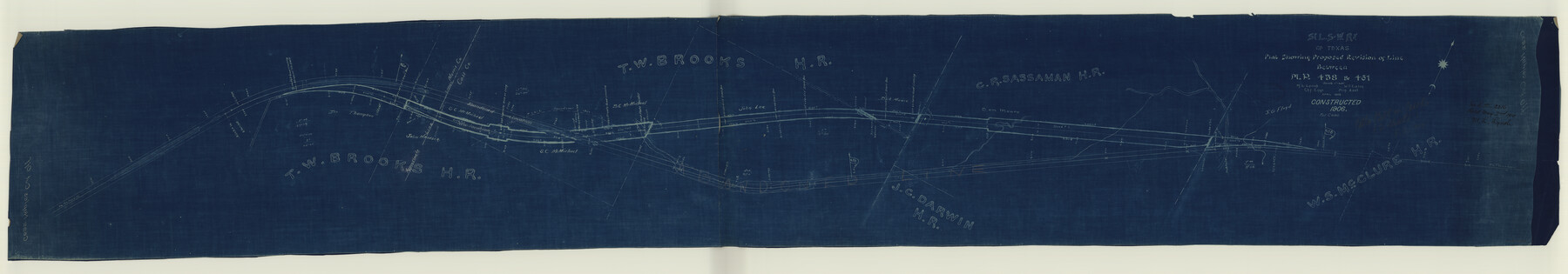
St. Louis Southwestern Railway of Texas
Z-2-120
-
Map/Doc
64445
-
Collection
General Map Collection
-
Object Dates
1905 (Creation Date)
1910/5/2 (File Date)
-
People and Organizations
Lynch, M L ()
Eaton, W T (Printer)
-
Counties
Cass Morris
-
Subjects
Railroads
-
Height x Width
15.3 x 87.2 inches
38.9 x 221.5 cm
-
Medium
blueprint/diazo
-
Scale
1"=200'
-
Comments
Cotton Belt, Plat showing proposed revision of line between Mile Post 458 and 461. See counter no. 64446 for sheet 2.
-
Features
SLS
Road to Gatesville
Road to Texarkana
Part of: General Map Collection
Montgomery County Sketch File 23

Print $6.00
- Digital $50.00
Montgomery County Sketch File 23
1841
Size 10.2 x 10.8 inches
Map/Doc 31865
Hydrographic Survey H-6396 of Outer Coast of Padre Island; Gulf of Mexico

Print $40.00
- Digital $50.00
Hydrographic Survey H-6396 of Outer Coast of Padre Island; Gulf of Mexico
1938
Size 54.4 x 33.5 inches
Map/Doc 2699
Wood County Working Sketch 18

Print $20.00
- Digital $50.00
Wood County Working Sketch 18
1959
Size 31.5 x 27.6 inches
Map/Doc 62018
Map of Stephens County

Print $20.00
- Digital $50.00
Map of Stephens County
1897
Size 43.0 x 37.3 inches
Map/Doc 78395
Palo Pinto County Sketch File 20

Print $6.00
- Digital $50.00
Palo Pinto County Sketch File 20
1891
Size 12.5 x 10.9 inches
Map/Doc 33402
Swisher County Sketch File 6

Print $20.00
- Digital $50.00
Swisher County Sketch File 6
Size 15.4 x 12.1 inches
Map/Doc 12404
Pecos County Sketch File 1

Print $20.00
- Digital $50.00
Pecos County Sketch File 1
Size 8.9 x 4.0 inches
Map/Doc 33642
[Surveys along the Colorado River]
![112, [Surveys along the Colorado River], General Map Collection](https://historictexasmaps.com/wmedia_w700/maps/112.tif.jpg)
Print $2.00
- Digital $50.00
[Surveys along the Colorado River]
1841
Size 12.2 x 8.3 inches
Map/Doc 112
Orange County Rolled Sketch 33

Print $40.00
- Digital $50.00
Orange County Rolled Sketch 33
Size 58.4 x 50.1 inches
Map/Doc 9652
Bee County Working Sketch 1

Print $20.00
- Digital $50.00
Bee County Working Sketch 1
Size 23.2 x 40.4 inches
Map/Doc 67251
Falls County Working Sketch 3

Print $20.00
- Digital $50.00
Falls County Working Sketch 3
1922
Size 34.0 x 27.8 inches
Map/Doc 69178
Val Verde County Rolled Sketch 77

Print $20.00
- Digital $50.00
Val Verde County Rolled Sketch 77
1981
Size 36.2 x 37.4 inches
Map/Doc 10087
You may also like
Atlas E, Sketch 29 (E-29)

Print $20.00
- Digital $50.00
Atlas E, Sketch 29 (E-29)
Size 22.4 x 33.2 inches
Map/Doc 78363
Flight Mission No. CRC-4R, Frame 106, Chambers County

Print $20.00
- Digital $50.00
Flight Mission No. CRC-4R, Frame 106, Chambers County
1956
Size 18.6 x 22.3 inches
Map/Doc 84903
Garza County Sketch File 5

Print $14.00
- Digital $50.00
Garza County Sketch File 5
1885
Size 9.8 x 8.1 inches
Map/Doc 24050
Mills County Working Sketch 26

Print $20.00
- Digital $50.00
Mills County Working Sketch 26
1993
Size 18.2 x 26.2 inches
Map/Doc 71056
Webb County Sketch File 13-1

Print $6.00
- Digital $50.00
Webb County Sketch File 13-1
Size 8.5 x 7.8 inches
Map/Doc 39804
Map of Galveston, Turtle & East Bays & portion of the Gulf of Mexico in Chambers & Galveston Counties, Texas showing subdivision therof for mineral development

Print $20.00
- Digital $50.00
Map of Galveston, Turtle & East Bays & portion of the Gulf of Mexico in Chambers & Galveston Counties, Texas showing subdivision therof for mineral development
1935
Size 40.7 x 47.7 inches
Map/Doc 2939
Lampasas County Boundary File 9

Print $6.00
- Digital $50.00
Lampasas County Boundary File 9
Size 11.2 x 8.7 inches
Map/Doc 56181
Cette Carte de Californie et du Nouveau Mexique est tiree de celle qui a ete envoyee par un grand d'Espagne pour etre communiquee a Mrs. de l'Academie Royale des Sciences

Print $20.00
- Digital $50.00
Cette Carte de Californie et du Nouveau Mexique est tiree de celle qui a ete envoyee par un grand d'Espagne pour etre communiquee a Mrs. de l'Academie Royale des Sciences
Size 11.8 x 16.5 inches
Map/Doc 95924
Lynn County Working Sketch Graphic Index

Print $20.00
- Digital $50.00
Lynn County Working Sketch Graphic Index
1961
Size 38.7 x 35.1 inches
Map/Doc 76627
[International & Great Northern Railroad, from Troupe to Overton]
![64388, [International & Great Northern Railroad, from Troupe to Overton], General Map Collection](https://historictexasmaps.com/wmedia_w700/maps/64388.tif.jpg)
Print $20.00
- Digital $50.00
[International & Great Northern Railroad, from Troupe to Overton]
1903
Size 25.1 x 38.4 inches
Map/Doc 64388
[Surveys near Carancahua Bay]
![106, [Surveys near Carancahua Bay], General Map Collection](https://historictexasmaps.com/wmedia_w700/maps/106.tif.jpg)
Print $2.00
- Digital $50.00
[Surveys near Carancahua Bay]
1844
Size 13.1 x 8.0 inches
Map/Doc 106
Mitchell County Working Sketch 8

Print $20.00
- Digital $50.00
Mitchell County Working Sketch 8
1975
Size 31.9 x 26.3 inches
Map/Doc 71065