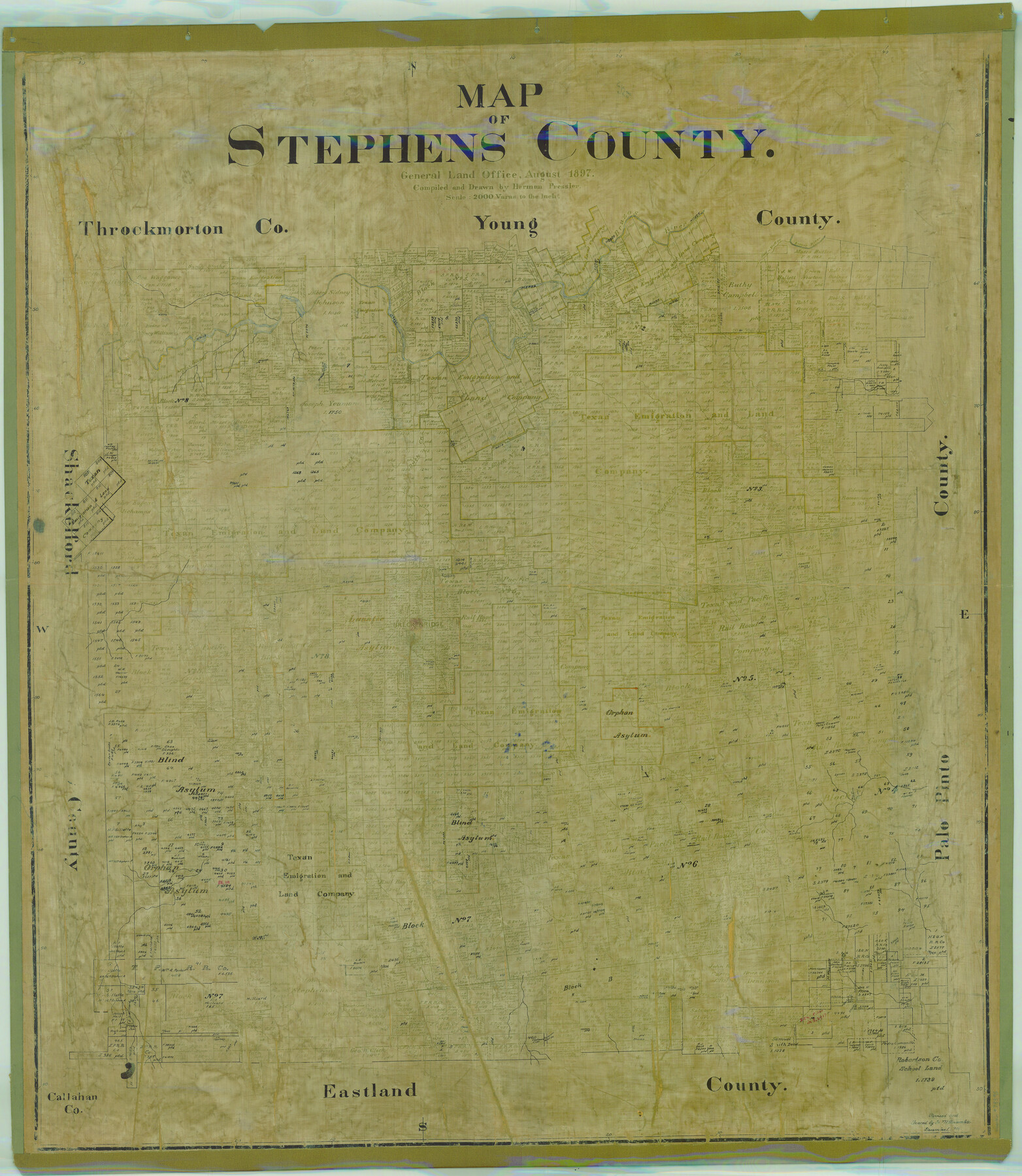
Map of Stephens County
- 
                          Map/Doc
78395
 - 
                            Collection
General Map Collection
 - 
                            Object Dates
1897 (Creation Date)
 - 
                            People and Organizations
Texas General Land Office (Publisher)
Herman Pressler (Compiler)
Herman Pressler (Draftsman)
 - 
                            Counties
Stephens
 - 
                            Subjects
County
 - 
                            Height x Width
43.0 x 37.3 inches
109.2 x 94.7 cm
 - 
                            Comments
Note on back: "Retired Nov. 30, 1940".
Revised and traced by H. M. Bramlette December 1, 1914.
Help Save Texas History - Adopt Me! - 
                            Features
Huffstuttle Creek
Brazos River
Scott Creek
Bluff Creek
Cramp's Creek
Cedar Creek
Duck Creek
Hubbard's Creek
East Fork of Hubbard's Creek
West Fork of Hubbard's Creek
T&P
Breckenridge
Sink Creek
Caddo Creek
 
Part of: General Map Collection
            Terrell County Rolled Sketch 28


                                            Print $40.00                    
                                             -                         Digital $50.00                                    
                Terrell County Rolled Sketch 28
1929
Size 28.0 x 67.7 inches
                                Map/Doc 7935
            
            Grayson County Boundary File 2


                                            Print $14.00                    
                                             -                         Digital $50.00                                    
                Grayson County Boundary File 2
Size 12.7 x 7.9 inches
                                Map/Doc 53931
            
            Hansford County Sketch File 1


                                            Print $7.00                    
                                             -                         Digital $50.00                                    
                Hansford County Sketch File 1
1888
Size 39.0 x 31.3 inches
                                Map/Doc 10475
            
            Coleman County Sketch File 19


                                            Print $4.00                    
                                             -                         Digital $50.00                                    
                Coleman County Sketch File 19
Size 12.5 x 8.1 inches
                                Map/Doc 18692
            
            Brazoria County Working Sketch 40


                                            Print $3.00                    
                                             -                         Digital $50.00                                    
                Brazoria County Working Sketch 40
1982
Size 11.0 x 10.8 inches
                                Map/Doc 67525
            
            McLennan County Sketch File 40


                                            Print $8.00                    
                                             -                         Digital $50.00                                    
                McLennan County Sketch File 40
1950
Size 14.2 x 8.7 inches
                                Map/Doc 31315
            
            Newton County Working Sketch 29


                                            Print $20.00                    
                                             -                         Digital $50.00                                    
                Newton County Working Sketch 29
1955
Size 21.2 x 39.8 inches
                                Map/Doc 71275
            
            [Beaumont, Sour Lake and Western Ry. Right of Way and Alignment - Frisco]


                                            Print $20.00                    
                                             -                         Digital $50.00                                    
                [Beaumont, Sour Lake and Western Ry. Right of Way and Alignment - Frisco]
1910
Size 20.1 x 45.9 inches
                                Map/Doc 64129
            
            Jefferson County Sketch File 21


                                            Print $10.00                    
                                             -                         Digital $50.00                                    
                Jefferson County Sketch File 21
Size 8.6 x 6.6 inches
                                Map/Doc 28171
            
            Dickens County Sketch File N


                                            Print $4.00                    
                                             -                         Digital $50.00                                    
                Dickens County Sketch File N
1903
Size 8.3 x 13.6 inches
                                Map/Doc 20942
            
            Bee County Working Sketch 14


                                            Print $20.00                    
                                             -                         Digital $50.00                                    
                Bee County Working Sketch 14
1948
Size 22.2 x 17.7 inches
                                Map/Doc 67264
            You may also like
            Comal County Sketch File 1


                                            Print $6.00                    
                                             -                         Digital $50.00                                    
                Comal County Sketch File 1
1846
Size 16.4 x 10.5 inches
                                Map/Doc 18995
            
            Flight Mission No. BQY-4M, Frame 34, Harris County


                                            Print $20.00                    
                                             -                         Digital $50.00                                    
                Flight Mission No. BQY-4M, Frame 34, Harris County
1953
Size 18.6 x 22.4 inches
                                Map/Doc 85249
            
            Blanco County Working Sketch 36


                                            Print $20.00                    
                                             -                         Digital $50.00                                    
                Blanco County Working Sketch 36
1979
Size 23.8 x 22.0 inches
                                Map/Doc 67396
            
            [Beaumont, Sour Lake and Western Ry. Right of Way and Alignment - Frisco]


                                            Print $20.00                    
                                             -                         Digital $50.00                                    
                [Beaumont, Sour Lake and Western Ry. Right of Way and Alignment - Frisco]
1910
Size 20.1 x 45.8 inches
                                Map/Doc 64127
            
            Texas Aerial Photo-Illustrated Map


            Texas Aerial Photo-Illustrated Map
Size 21.3 x 28.3 inches
                                Map/Doc 94397
            
            Revised map of Matagorda Bay and vicinity in Matagorda and Calhoun Counties showing subdivision for mineral development


                                            Print $40.00                    
                                             -                         Digital $50.00                                    
                Revised map of Matagorda Bay and vicinity in Matagorda and Calhoun Counties showing subdivision for mineral development
1941
Size 43.4 x 56.6 inches
                                Map/Doc 3098
            
            Flight Mission No. BRE-1P, Frame 126, Nueces County


                                            Print $20.00                    
                                             -                         Digital $50.00                                    
                Flight Mission No. BRE-1P, Frame 126, Nueces County
1956
Size 18.4 x 22.4 inches
                                Map/Doc 86692
            
            Lipscomb County Boundary File 14b


                                            Print $60.00                    
                                             -                         Digital $50.00                                    
                Lipscomb County Boundary File 14b
Size 7.3 x 8.7 inches
                                Map/Doc 56370
            
            Franklin County Sketch File 17


                                            Print $16.00                    
                                             -                         Digital $50.00                                    
                Franklin County Sketch File 17
1951
Size 11.3 x 8.8 inches
                                Map/Doc 23026
            
            Flight Mission No. CUG-3P, Frame 162, Kleberg County


                                            Print $20.00                    
                                             -                         Digital $50.00                                    
                Flight Mission No. CUG-3P, Frame 162, Kleberg County
1956
Size 18.5 x 22.3 inches
                                Map/Doc 86282
            
            Freestone County Sketch File 16


                                            Print $4.00                    
                                             -                         Digital $50.00                                    
                Freestone County Sketch File 16
Size 6.4 x 8.7 inches
                                Map/Doc 23072