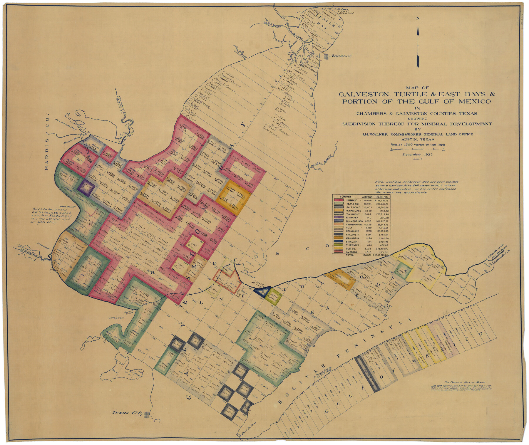
Map of Galveston, Turtle & East Bays & portion of the Gulf of Mexico in Chambers & Galveston Counties, Texas showing subdivision therof for mineral development
K-3-25
-
Map/Doc
2939
-
Collection
General Map Collection
-
Object Dates
1935 (Creation Date)
-
People and Organizations
J.O. Barrow (Draftsman)
-
Counties
Chambers Galveston
-
Subjects
Energy Offshore Submerged Area
-
Height x Width
40.7 x 47.7 inches
103.4 x 121.2 cm
-
Medium
blueprint/diazo
Part of: General Map Collection
San Patricio County Rolled Sketch 42

Print $20.00
- Digital $50.00
San Patricio County Rolled Sketch 42
Size 18.6 x 37.3 inches
Map/Doc 7728
Jack County Sketch File 34

Print $20.00
- Digital $50.00
Jack County Sketch File 34
1951
Size 21.2 x 29.3 inches
Map/Doc 11832
Madison County Rolled Sketch 1

Print $20.00
- Digital $50.00
Madison County Rolled Sketch 1
1966
Size 36.7 x 46.0 inches
Map/Doc 9485
Howard County Sketch File 6

Print $44.00
- Digital $50.00
Howard County Sketch File 6
1929
Size 18.6 x 14.4 inches
Map/Doc 26861
Bell County, Milam District

Print $20.00
- Digital $50.00
Bell County, Milam District
1877
Size 23.5 x 28.6 inches
Map/Doc 3293
Shelby County

Print $40.00
- Digital $50.00
Shelby County
1897
Size 43.4 x 50.1 inches
Map/Doc 63033
Fort Bend County State Real Property Sketch 17

Print $20.00
- Digital $50.00
Fort Bend County State Real Property Sketch 17
1985
Size 17.8 x 22.8 inches
Map/Doc 61665
Parker County Sketch File 11

Print $4.00
- Digital $50.00
Parker County Sketch File 11
1859
Size 12.8 x 8.1 inches
Map/Doc 33542
Nueces County Rolled Sketch 81

Print $278.00
- Digital $50.00
Nueces County Rolled Sketch 81
1982
Size 24.3 x 36.2 inches
Map/Doc 6960
San Patricio County Rolled Sketch 46

Print $20.00
- Digital $50.00
San Patricio County Rolled Sketch 46
1983
Size 19.6 x 25.5 inches
Map/Doc 7730

Dimmit County Working Sketch 8

Print $20.00
- Digital $50.00
Dimmit County Working Sketch 8
1930
Size 35.8 x 29.9 inches
Map/Doc 68669
You may also like
Corpus Christi Harbor

Print $40.00
- Digital $50.00
Corpus Christi Harbor
1972
Size 36.9 x 52.3 inches
Map/Doc 73477
Johnson County Boundary File 51

Print $66.00
- Digital $50.00
Johnson County Boundary File 51
Size 8.5 x 4.2 inches
Map/Doc 55589
Culberson County Working Sketch 81

Print $40.00
- Digital $50.00
Culberson County Working Sketch 81
1980
Size 61.5 x 43.5 inches
Map/Doc 68535
Jackson County

Print $20.00
- Digital $50.00
Jackson County
1920
Size 46.9 x 40.1 inches
Map/Doc 95541
Flight Mission No. CGI-4N, Frame 175, Cameron County

Print $20.00
- Digital $50.00
Flight Mission No. CGI-4N, Frame 175, Cameron County
1955
Size 18.6 x 22.4 inches
Map/Doc 84678
Kimble County Sketch File C

Print $4.00
- Digital $50.00
Kimble County Sketch File C
Size 14.9 x 7.5 inches
Map/Doc 28965
Val Verde County Rolled Sketch 74

Print $20.00
- Digital $50.00
Val Verde County Rolled Sketch 74
Size 18.9 x 19.5 inches
Map/Doc 8137
Reeves County Rolled Sketch 24

Print $20.00
- Digital $50.00
Reeves County Rolled Sketch 24
1982
Size 40.6 x 28.4 inches
Map/Doc 7492
Brewster County Sketch File NS-9

Print $40.00
- Digital $50.00
Brewster County Sketch File NS-9
1944
Size 14.2 x 8.9 inches
Map/Doc 16135
Brewster County Sketch File NS-4c

Print $6.00
- Digital $50.00
Brewster County Sketch File NS-4c
Size 9.2 x 7.3 inches
Map/Doc 15958

Kerr County Working Sketch 19

Print $20.00
- Digital $50.00
Kerr County Working Sketch 19
1959
Size 34.5 x 41.3 inches
Map/Doc 70050