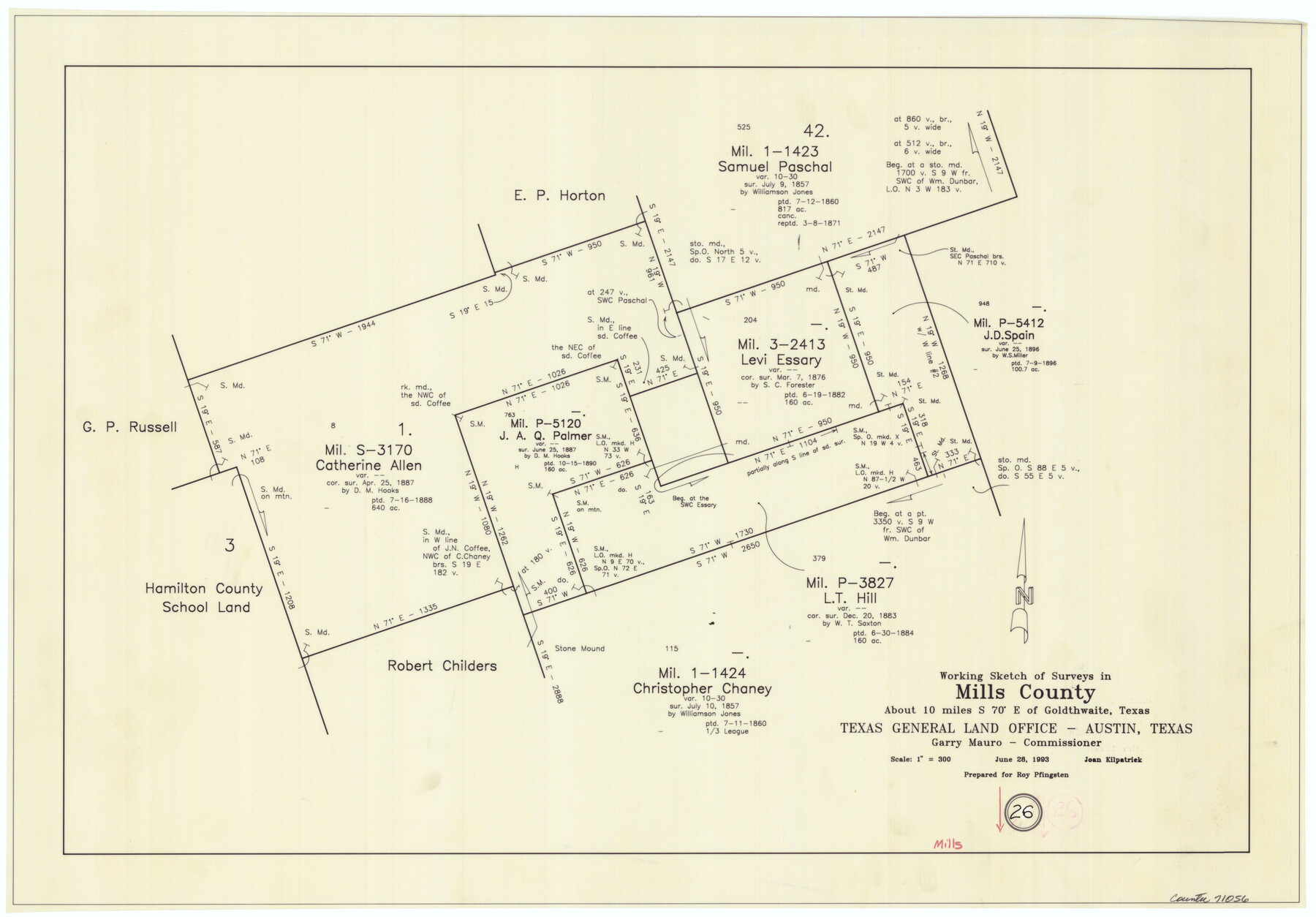
Mills County Working Sketch 26
-
Map/Doc
71056
-
Collection
General Map Collection
-
Object Dates
6/28/1993 (Creation Date)
-
People and Organizations
Joan Kilpatrick (Draftsman)
-
Counties
Mills
-
Subjects
Surveying Working Sketch
-
Height x Width
18.2 x 26.2 inches
46.2 x 66.6 cm
-
Scale
1" = 300 varas
Part of: General Map Collection
Foard County Sketch File 12

Print $4.00
- Digital $50.00
Foard County Sketch File 12
1881
Size 11.0 x 8.5 inches
Map/Doc 22814
Freestone County Working Sketch 25

Print $20.00
- Digital $50.00
Freestone County Working Sketch 25
1984
Size 43.5 x 38.4 inches
Map/Doc 69267
Flight Mission No. CRC-4R, Frame 175, Chambers County

Print $20.00
- Digital $50.00
Flight Mission No. CRC-4R, Frame 175, Chambers County
1956
Size 18.6 x 22.2 inches
Map/Doc 84926
Zavala County Rolled Sketch 30

Print $20.00
- Digital $50.00
Zavala County Rolled Sketch 30
Size 18.6 x 19.1 inches
Map/Doc 8331
Flight Mission No. DQO-8K, Frame 46, Galveston County

Print $20.00
- Digital $50.00
Flight Mission No. DQO-8K, Frame 46, Galveston County
1952
Size 18.7 x 22.4 inches
Map/Doc 85153
Midland County Sketch File 1

Print $20.00
- Digital $50.00
Midland County Sketch File 1
1886
Size 25.7 x 16.1 inches
Map/Doc 12079
Jack County Sketch File 18b

Print $4.00
- Digital $50.00
Jack County Sketch File 18b
Size 8.0 x 12.9 inches
Map/Doc 27557
Flight Mission No. BRE-1P, Frame 10, Nueces County

Print $20.00
- Digital $50.00
Flight Mission No. BRE-1P, Frame 10, Nueces County
1956
Size 18.4 x 22.5 inches
Map/Doc 86618
Railroad Track Map, H&TCRRCo., Falls County, Texas

Print $4.00
- Digital $50.00
Railroad Track Map, H&TCRRCo., Falls County, Texas
1918
Size 11.6 x 18.3 inches
Map/Doc 62855

Flight Mission No. BRE-1P, Frame 32, Nueces County

Print $20.00
- Digital $50.00
Flight Mission No. BRE-1P, Frame 32, Nueces County
1956
Size 18.4 x 22.6 inches
Map/Doc 86628
Aransas County Boundary File 5b

Print $8.00
- Digital $50.00
Aransas County Boundary File 5b
Size 14.3 x 8.8 inches
Map/Doc 49802
You may also like
Bailey County Working Sketch 3

Print $20.00
- Digital $50.00
Bailey County Working Sketch 3
1922
Size 17.3 x 28.0 inches
Map/Doc 67590
Rockwall County Sketch File 9

Print $20.00
Rockwall County Sketch File 9
Size 31.1 x 39.7 inches
Map/Doc 10590
Dimmit County Rolled Sketch 6

Print $20.00
- Digital $50.00
Dimmit County Rolled Sketch 6
Size 31.1 x 27.4 inches
Map/Doc 5716
Hardin County Sketch File 63

Print $10.00
- Digital $50.00
Hardin County Sketch File 63
Size 11.3 x 8.8 inches
Map/Doc 25238
Dallas County Boundary File 3

Print $6.00
- Digital $50.00
Dallas County Boundary File 3
Size 14.2 x 8.6 inches
Map/Doc 52120
Milam County Boundary File 6c

Print $2.00
- Digital $50.00
Milam County Boundary File 6c
Size 11.2 x 8.5 inches
Map/Doc 57250
Dawson County Sketch File A

Print $28.00
- Digital $50.00
Dawson County Sketch File A
1903
Size 11.4 x 8.8 inches
Map/Doc 20461
Bosque County Working Sketch 23

Print $20.00
- Digital $50.00
Bosque County Working Sketch 23
1984
Size 17.4 x 23.6 inches
Map/Doc 67456
[Block A, Section 1, Block O, Sections 1 and 3]
![91390, [Block A, Section 1, Block O, Sections 1 and 3], Twichell Survey Records](https://historictexasmaps.com/wmedia_w700/maps/91390-1.tif.jpg)
Print $2.00
- Digital $50.00
[Block A, Section 1, Block O, Sections 1 and 3]
Size 8.5 x 8.4 inches
Map/Doc 91390
[H. & G. N. Block B4]
![90275, [H. & G. N. Block B4], Twichell Survey Records](https://historictexasmaps.com/wmedia_w700/maps/90275-1.tif.jpg)
Print $20.00
- Digital $50.00
[H. & G. N. Block B4]
Size 21.4 x 18.2 inches
Map/Doc 90275
Sectional Map No. 2 of the lands and the line of the Texas & Pacific Ry. Co. in Howard, Martin, Andrews, Midland and Tom Green Counties

Print $20.00
- Digital $50.00
Sectional Map No. 2 of the lands and the line of the Texas & Pacific Ry. Co. in Howard, Martin, Andrews, Midland and Tom Green Counties
1885
Size 18.9 x 23.4 inches
Map/Doc 4859
Fisher County Working Sketch Graphic Index

Print $20.00
- Digital $50.00
Fisher County Working Sketch Graphic Index
1944
Size 46.9 x 41.4 inches
Map/Doc 76542