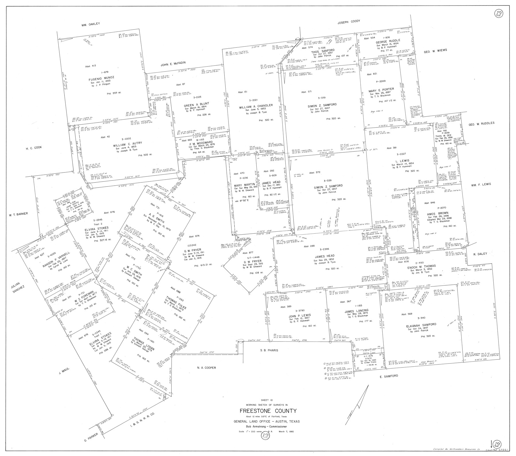
Freestone County Working Sketch 19
-
Map/Doc
69261
-
Collection
General Map Collection
-
Object Dates
3/7/1980 (Creation Date)
-
People and Organizations
Beverly Robison (Draftsman)
-
Counties
Freestone
-
Subjects
Surveying Working Sketch
-
Height x Width
39.3 x 44.4 inches
99.8 x 112.8 cm
-
Scale
1" = 200 varas
Part of: General Map Collection
Brewster County Rolled Sketch 15

Print $20.00
- Digital $50.00
Brewster County Rolled Sketch 15
1889
Size 32.8 x 26.4 inches
Map/Doc 5194
Wise County Sketch File 54

Print $22.00
- Digital $50.00
Wise County Sketch File 54
2012
Size 11.0 x 8.5 inches
Map/Doc 93553
Kinney County Working Sketch 35

Print $40.00
- Digital $50.00
Kinney County Working Sketch 35
1965
Size 58.3 x 48.6 inches
Map/Doc 70217
Brassos Santiago

Print $20.00
- Digital $50.00
Brassos Santiago
1853
Size 25.3 x 18.3 inches
Map/Doc 72913
Hall County Working Sketch 5

Print $20.00
- Digital $50.00
Hall County Working Sketch 5
1938
Size 21.7 x 25.2 inches
Map/Doc 63333
Titus County Sketch File 1

Print $4.00
- Digital $50.00
Titus County Sketch File 1
Size 13.3 x 8.2 inches
Map/Doc 38130
Flight Mission No. BQY-4M, Frame 125, Harris County

Print $20.00
- Digital $50.00
Flight Mission No. BQY-4M, Frame 125, Harris County
1953
Size 18.6 x 22.5 inches
Map/Doc 85293
Caldwell County Working Sketch 12

Print $20.00
- Digital $50.00
Caldwell County Working Sketch 12
1979
Size 47.7 x 44.2 inches
Map/Doc 67842
Texas & Pacific Railway, Longview to Dallas

Print $40.00
- Digital $50.00
Texas & Pacific Railway, Longview to Dallas
1873
Size 14.8 x 100.8 inches
Map/Doc 64099
Henderson County Rolled Sketch 11

Print $20.00
- Digital $50.00
Henderson County Rolled Sketch 11
1915
Size 29.2 x 42.9 inches
Map/Doc 76149
Hudspeth County Sketch File 53

Print $6.00
- Digital $50.00
Hudspeth County Sketch File 53
1993
Size 14.3 x 8.9 inches
Map/Doc 27076
Colorado River, Willow Creek Valley Sheet[/Near Kirtley, Texas Mapped in Cooperation with Commissioner's Court of Fayette Co.]
![65322, Colorado River, Willow Creek Valley Sheet[/Near Kirtley, Texas Mapped in Cooperation with Commissioner's Court of Fayette Co.], General Map Collection](https://historictexasmaps.com/wmedia_w700/maps/65322.tif.jpg)
Print $20.00
- Digital $50.00
Colorado River, Willow Creek Valley Sheet[/Near Kirtley, Texas Mapped in Cooperation with Commissioner's Court of Fayette Co.]
1938
Size 38.2 x 40.8 inches
Map/Doc 65322
You may also like
Hockley County Map

Print $20.00
- Digital $50.00
Hockley County Map
Size 20.4 x 21.4 inches
Map/Doc 91195
Edwards County Boundary File 27

Print $8.00
- Digital $50.00
Edwards County Boundary File 27
Size 8.8 x 3.9 inches
Map/Doc 52876
Sutton County Working Sketch 46

Print $40.00
- Digital $50.00
Sutton County Working Sketch 46
1953
Size 48.4 x 27.1 inches
Map/Doc 62389
Foard County Sketch File 29

Print $20.00
- Digital $50.00
Foard County Sketch File 29
Size 18.9 x 29.4 inches
Map/Doc 11494
Bell County Sketch File 20

Print $4.00
- Digital $50.00
Bell County Sketch File 20
1855
Size 9.0 x 7.9 inches
Map/Doc 14406
Jones County Sketch File 16

Print $20.00
- Digital $50.00
Jones County Sketch File 16
1945
Size 23.7 x 19.0 inches
Map/Doc 11901
Edwards County Rolled Sketch 7

Print $20.00
- Digital $50.00
Edwards County Rolled Sketch 7
1881
Size 24.4 x 23.2 inches
Map/Doc 5800
Lynn County Rolled Sketch B

Print $20.00
- Digital $50.00
Lynn County Rolled Sketch B
1908
Size 27.9 x 33.1 inches
Map/Doc 6653
Flight Mission No. BQR-9K, Frame 15, Brazoria County

Print $20.00
- Digital $50.00
Flight Mission No. BQR-9K, Frame 15, Brazoria County
1952
Size 18.8 x 22.5 inches
Map/Doc 84044
Upton County Working Sketch 48

Print $20.00
- Digital $50.00
Upton County Working Sketch 48
1975
Size 29.3 x 24.3 inches
Map/Doc 69544
Armstrong County Rolled Sketch OS

Print $20.00
- Digital $50.00
Armstrong County Rolled Sketch OS
1902
Size 17.5 x 32.4 inches
Map/Doc 5086
Concho County Working Sketch 24

Print $20.00
- Digital $50.00
Concho County Working Sketch 24
1981
Size 35.0 x 44.2 inches
Map/Doc 68206