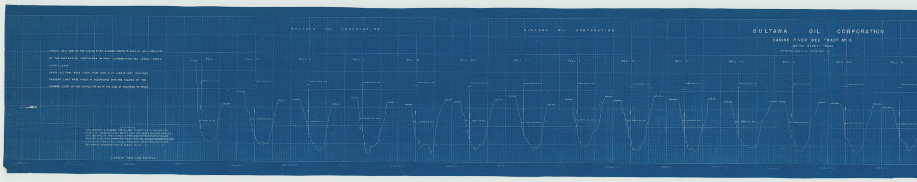
Gregg County Rolled Sketch 26
Sultana Oil Corporation, Sabine River Bed Tract No. 6
-
Map/Doc
9077
-
Collection
General Map Collection
-
Object Dates
1937/6/16 (Creation Date)
1976/2/27 (File Date)
-
People and Organizations
M.H. Hackney (Surveyor/Engineer)
-
Counties
Gregg
-
Subjects
Surveying Rolled Sketch
-
Height x Width
25.8 x 129.0 inches
65.5 x 327.7 cm
-
Medium
blueprint/diazo
-
Comments
Segment 1 of 2. See Gregg County Rolled Sketch 26 (76432) for segment 2.
Related maps
Gregg County Rolled Sketch 26

Print $40.00
- Digital $50.00
Gregg County Rolled Sketch 26
1937
Size 26.4 x 126.6 inches
Map/Doc 76432
Part of: General Map Collection
Cameron County Working Sketch 3

Print $20.00
- Digital $50.00
Cameron County Working Sketch 3
1964
Size 40.8 x 38.6 inches
Map/Doc 67882
Flight Mission No. DQN-5K, Frame 26, Calhoun County

Print $20.00
- Digital $50.00
Flight Mission No. DQN-5K, Frame 26, Calhoun County
1953
Size 18.6 x 22.3 inches
Map/Doc 84377
Andrews County Rolled Sketch 29

Print $20.00
- Digital $50.00
Andrews County Rolled Sketch 29
1949
Size 36.6 x 16.3 inches
Map/Doc 77173
Flight Mission No. CRE-1R, Frame 124, Jackson County

Print $20.00
- Digital $50.00
Flight Mission No. CRE-1R, Frame 124, Jackson County
1956
Size 16.1 x 15.9 inches
Map/Doc 85335
Matagorda County Sketch File 43

Print $20.00
- Digital $50.00
Matagorda County Sketch File 43
1839
Size 13.2 x 8.2 inches
Map/Doc 30868
Uvalde County Working Sketch 36

Print $20.00
- Digital $50.00
Uvalde County Working Sketch 36
1965
Size 24.8 x 32.9 inches
Map/Doc 72106
Caldwell County Working Sketch 10

Print $40.00
- Digital $50.00
Caldwell County Working Sketch 10
1977
Size 46.2 x 50.5 inches
Map/Doc 67840
Reeves County Working Sketch 63

Print $20.00
- Digital $50.00
Reeves County Working Sketch 63
1984
Size 35.7 x 33.4 inches
Map/Doc 63506
Jack County Working Sketch 15

Print $20.00
- Digital $50.00
Jack County Working Sketch 15
1982
Size 30.6 x 25.9 inches
Map/Doc 66441
Tyler County Working Sketch 25

Print $20.00
- Digital $50.00
Tyler County Working Sketch 25
1909
Size 29.8 x 26.7 inches
Map/Doc 69495
Pecos County Rolled Sketch 149

Print $20.00
- Digital $50.00
Pecos County Rolled Sketch 149
1958
Size 36.0 x 38.5 inches
Map/Doc 9735
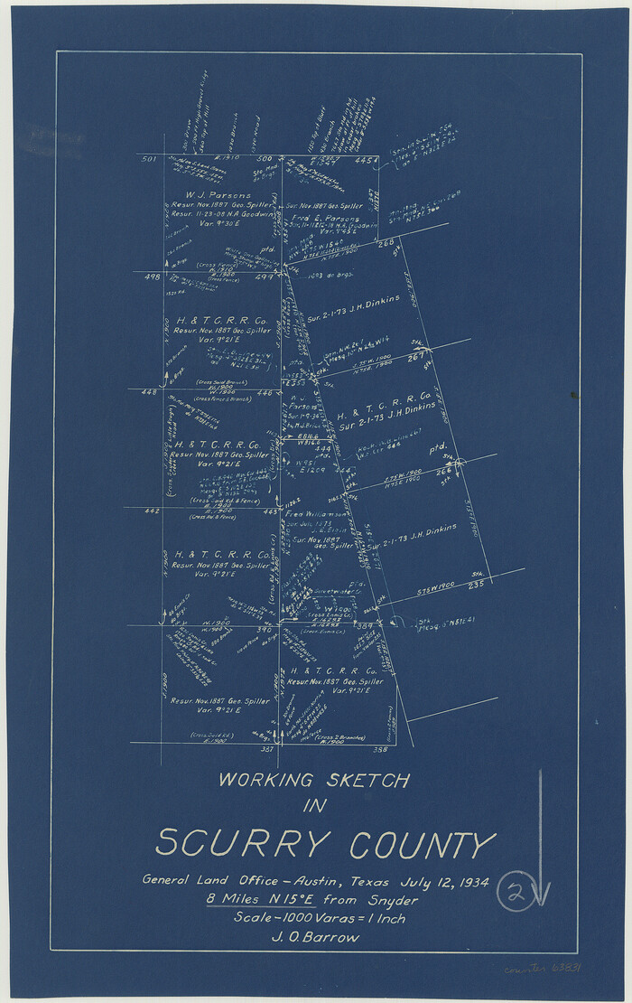
Scurry County Working Sketch 2
Print $3.00
- Digital $50.00
Scurry County Working Sketch 2
1934
Size 16.2 x 10.2 inches
Map/Doc 63831
You may also like
Castro County Sketch File 4

Print $6.00
- Digital $50.00
Castro County Sketch File 4
1908
Size 6.9 x 8.9 inches
Map/Doc 17462
Rio Grande Rectification Project, El Paso and Juarez Valley

Print $20.00
- Digital $50.00
Rio Grande Rectification Project, El Paso and Juarez Valley
1935
Size 10.9 x 29.6 inches
Map/Doc 60868
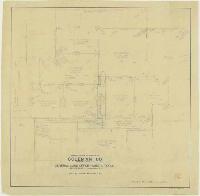
Coleman County Working Sketch 12
Print $20.00
- Digital $50.00
Coleman County Working Sketch 12
1951
Size 25.7 x 26.2 inches
Map/Doc 68078
Freestone County Rolled Sketch 7

Print $20.00
- Digital $50.00
Freestone County Rolled Sketch 7
1918
Size 41.4 x 36.9 inches
Map/Doc 8895
Bexar County Rolled Sketch 4

Print $20.00
- Digital $50.00
Bexar County Rolled Sketch 4
Size 24.3 x 36.8 inches
Map/Doc 5137
Flight Mission No. CUG-3P, Frame 35, Kleberg County

Print $20.00
- Digital $50.00
Flight Mission No. CUG-3P, Frame 35, Kleberg County
1956
Size 18.6 x 22.3 inches
Map/Doc 86240
General Highway Map, Aransas County, Texas

Print $20.00
General Highway Map, Aransas County, Texas
1961
Size 18.3 x 25.0 inches
Map/Doc 79352
University Land Field Notes for Blocks A, B, C, D, E, F, G, H, I, and J in Hudspeth County

University Land Field Notes for Blocks A, B, C, D, E, F, G, H, I, and J in Hudspeth County
Map/Doc 81712
Right of Way and Track Map of The Wichita Falls & Southern Railroad Company

Print $40.00
- Digital $50.00
Right of Way and Track Map of The Wichita Falls & Southern Railroad Company
1942
Size 24.7 x 56.3 inches
Map/Doc 64521
Erath County Sketch File 32

Print $8.00
- Digital $50.00
Erath County Sketch File 32
1936
Size 11.5 x 8.8 inches
Map/Doc 22311
Calhoun County Rolled Sketch 36

Print $40.00
- Digital $50.00
Calhoun County Rolled Sketch 36
2003
Size 33.3 x 49.0 inches
Map/Doc 78655
Brewster County Boundary File 2

Print $40.00
- Digital $50.00
Brewster County Boundary File 2
Size 14.0 x 16.3 inches
Map/Doc 50756