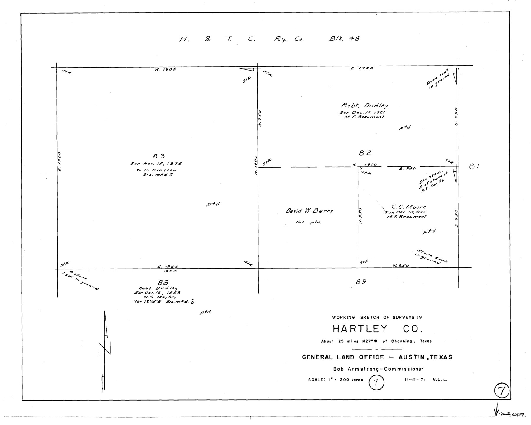
Hartley County Working Sketch 7
-
Map/Doc
66057
-
Collection
General Map Collection
-
Object Dates
11/11/1971 (Creation Date)
-
People and Organizations
M. L. Liles (Draftsman)
-
Counties
Hartley
-
Subjects
Surveying Working Sketch
-
Height x Width
20.1 x 25.1 inches
51.1 x 63.8 cm
-
Scale
1" = 200 varas
Part of: General Map Collection
Burnet County Sketch File 40

Print $4.00
- Digital $50.00
Burnet County Sketch File 40
Size 14.2 x 8.6 inches
Map/Doc 16755
Glasscock County Sketch File 13

Print $20.00
- Digital $50.00
Glasscock County Sketch File 13
1935
Size 18.8 x 17.8 inches
Map/Doc 11562
Culberson County Working Sketch 81

Print $40.00
- Digital $50.00
Culberson County Working Sketch 81
1980
Size 61.5 x 43.5 inches
Map/Doc 68535
Travis County Working Sketch 47

Print $40.00
- Digital $50.00
Travis County Working Sketch 47
1981
Size 55.5 x 41.8 inches
Map/Doc 69431
Crockett County Rolled Sketch 26

Print $20.00
- Digital $50.00
Crockett County Rolled Sketch 26
Size 33.7 x 40.9 inches
Map/Doc 5585
Hardeman County Sketch File 32

Print $4.00
- Digital $50.00
Hardeman County Sketch File 32
Size 11.1 x 8.9 inches
Map/Doc 25068
Bosque County

Print $40.00
- Digital $50.00
Bosque County
1945
Size 48.3 x 38.0 inches
Map/Doc 73083
Winkler County Sketch File 10

Print $4.00
- Digital $50.00
Winkler County Sketch File 10
1910
Size 9.1 x 8.3 inches
Map/Doc 40486
Titus County Working Sketch 2

Print $20.00
- Digital $50.00
Titus County Working Sketch 2
Size 23.6 x 25.3 inches
Map/Doc 69363
Johnson County Rolled Sketch 1

Print $20.00
- Digital $50.00
Johnson County Rolled Sketch 1
1941
Size 19.4 x 33.4 inches
Map/Doc 6446
Crosby County Working Sketch 8

Print $20.00
- Digital $50.00
Crosby County Working Sketch 8
1938
Size 42.3 x 37.2 inches
Map/Doc 68442
Rusk County Working Sketch 26

Print $20.00
- Digital $50.00
Rusk County Working Sketch 26
1938
Size 42.8 x 36.8 inches
Map/Doc 63662
You may also like
Deaf Smith County, Texas / [Sec. 144, Blk. K-5]
![92037, Deaf Smith County, Texas / [Sec. 144, Blk. K-5], Twichell Survey Records](https://historictexasmaps.com/wmedia_w700/maps/92037-1.tif.jpg)
Print $20.00
- Digital $50.00
Deaf Smith County, Texas / [Sec. 144, Blk. K-5]
Size 25.6 x 19.6 inches
Map/Doc 92037
Coke County Rolled Sketch 7

Print $20.00
- Digital $50.00
Coke County Rolled Sketch 7
Size 19.0 x 24.1 inches
Map/Doc 5506
Montague County Sketch File 8

Print $22.00
- Digital $50.00
Montague County Sketch File 8
Size 8.1 x 3.7 inches
Map/Doc 31722
Brazos Santiago

Print $20.00
- Digital $50.00
Brazos Santiago
1884
Size 24.4 x 18.2 inches
Map/Doc 73030
Map of the Mexican National Railway showing the lines granted by the Mexican Government to the Mexican National Construction Company (Palmer-Sullivan Concession)

Print $20.00
Map of the Mexican National Railway showing the lines granted by the Mexican Government to the Mexican National Construction Company (Palmer-Sullivan Concession)
1881
Size 26.8 x 40.6 inches
Map/Doc 95315
Brewster County Sketch File N-5

Print $6.00
- Digital $50.00
Brewster County Sketch File N-5
Size 12.9 x 8.6 inches
Map/Doc 15605
Hudspeth County Sketch File 20

Print $40.00
- Digital $50.00
Hudspeth County Sketch File 20
Size 37.1 x 57.3 inches
Map/Doc 10494
Refugio County Boundary File 2

Print $32.00
- Digital $50.00
Refugio County Boundary File 2
Size 14.1 x 8.8 inches
Map/Doc 58233
Angelina County Working Sketch 54

Print $20.00
- Digital $50.00
Angelina County Working Sketch 54
1989
Size 31.6 x 26.9 inches
Map/Doc 67138
Map of Val Verde County

Print $40.00
- Digital $50.00
Map of Val Verde County
1898
Size 80.7 x 42.7 inches
Map/Doc 16913
Starr County Rolled Sketch 33

Print $20.00
- Digital $50.00
Starr County Rolled Sketch 33
1944
Size 21.9 x 30.8 inches
Map/Doc 7830
Intracoastal Waterway - Port Arthur to Galveston Bay

Print $20.00
- Digital $50.00
Intracoastal Waterway - Port Arthur to Galveston Bay
1961
Size 26.7 x 38.8 inches
Map/Doc 69834