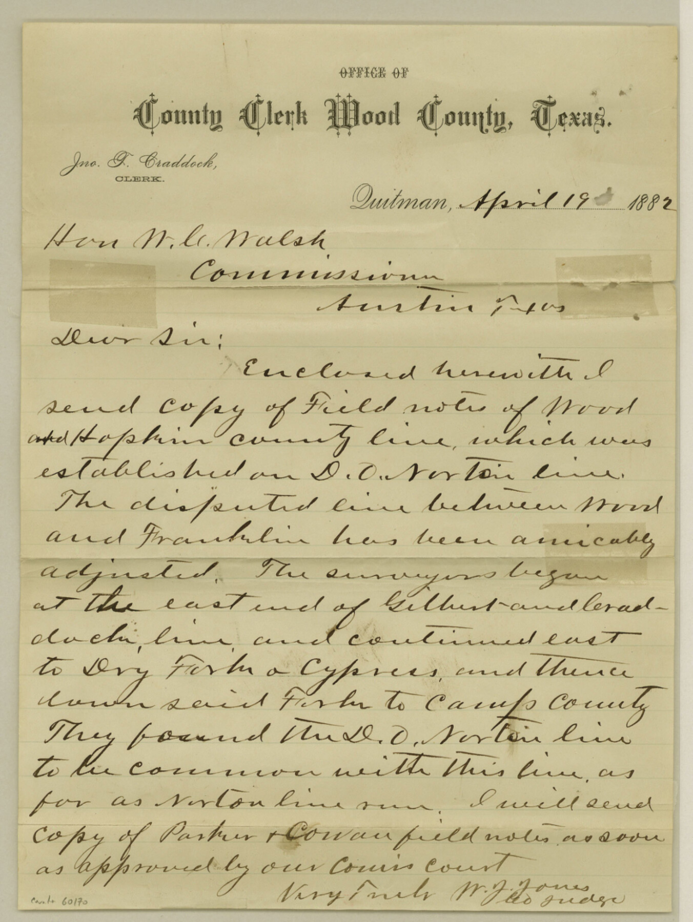
Wood County Boundary File 5
Fieldnotes of County line between Wood and Hopkins Cos.
-
Map/Doc
60170
-
Collection
General Map Collection
-
Counties
Wood
-
Subjects
County Boundaries
-
Height x Width
10.8 x 8.1 inches
27.4 x 20.6 cm
Part of: General Map Collection
Map of the River Sabine from Logan's Ferry to 32nd degree of north latitude

Print $3.00
- Digital $50.00
Map of the River Sabine from Logan's Ferry to 32nd degree of north latitude
1841
Size 8.7 x 11.1 inches
Map/Doc 94497
Map of Jefferson County

Print $20.00
- Digital $50.00
Map of Jefferson County
1896
Size 25.3 x 21.6 inches
Map/Doc 3731
Aransas County Rolled Sketch 33

Print $20.00
- Digital $50.00
Aransas County Rolled Sketch 33
1997
Size 24.5 x 36.8 inches
Map/Doc 78495
Revised Map of Matagorda Bay and Vicinity in Matagorda and Calhoun Counties showing subdivision for mineral development

Print $40.00
- Digital $50.00
Revised Map of Matagorda Bay and Vicinity in Matagorda and Calhoun Counties showing subdivision for mineral development
1941
Size 44.3 x 60.0 inches
Map/Doc 2933
Castro County Boundary File 1c

Print $40.00
- Digital $50.00
Castro County Boundary File 1c
Size 24.2 x 19.2 inches
Map/Doc 51224
Val Verde County Working Sketch 112

Print $40.00
- Digital $50.00
Val Verde County Working Sketch 112
1990
Size 48.2 x 30.8 inches
Map/Doc 72247
Hudspeth County Sketch File 37

Print $80.00
- Digital $50.00
Hudspeth County Sketch File 37
Size 12.5 x 98.3 inches
Map/Doc 27008

Harris County Rolled Sketch R & B

Print $40.00
- Digital $50.00
Harris County Rolled Sketch R & B
1901
Size 63.8 x 30.0 inches
Map/Doc 8344
Wheeler County Sketch File 3

Print $24.00
- Digital $50.00
Wheeler County Sketch File 3
1881
Size 12.9 x 8.4 inches
Map/Doc 39998
Harris County Sketch File 88

Print $171.00
- Digital $50.00
Harris County Sketch File 88
1914
Size 13.8 x 12.1 inches
Map/Doc 25555
West Part of Anderson County

Print $20.00
- Digital $50.00
West Part of Anderson County
1942
Size 41.8 x 34.3 inches
Map/Doc 77197
You may also like
Terrell County Working Sketch Graphic index - sheet B

Print $20.00
- Digital $50.00
Terrell County Working Sketch Graphic index - sheet B
1931
Size 47.7 x 39.6 inches
Map/Doc 76711
Calhoun County Rolled Sketch 27

Print $127.00
- Digital $50.00
Calhoun County Rolled Sketch 27
1976
Size 10.1 x 16.0 inches
Map/Doc 43621
Jeff Davis County Rolled Sketch 32

Print $20.00
- Digital $50.00
Jeff Davis County Rolled Sketch 32
1984
Size 16.3 x 24.5 inches
Map/Doc 7721
Johnson County Working Sketch 28

Print $20.00
- Digital $50.00
Johnson County Working Sketch 28
2005
Size 24.0 x 26.0 inches
Map/Doc 84700
Sutton County Sketch File 9

Print $6.00
- Digital $50.00
Sutton County Sketch File 9
1893
Size 14.2 x 8.5 inches
Map/Doc 37367
Flight Mission No. CGI-4N, Frame 174, Cameron County

Print $20.00
- Digital $50.00
Flight Mission No. CGI-4N, Frame 174, Cameron County
1955
Size 18.7 x 22.3 inches
Map/Doc 84677
Motley County Sketch File F (S)

Print $14.00
- Digital $50.00
Motley County Sketch File F (S)
1904
Size 9.1 x 5.9 inches
Map/Doc 32179
[Surveys in the Robertson District along the Trinity River and Richland Creek]
![104, [Surveys in the Robertson District along the Trinity River and Richland Creek], General Map Collection](https://historictexasmaps.com/wmedia_w700/maps/104.tif.jpg)
Print $20.00
- Digital $50.00
[Surveys in the Robertson District along the Trinity River and Richland Creek]
1841
Size 15.3 x 12.2 inches
Map/Doc 104
Flight Mission No. DCL-7C, Frame 58, Kenedy County

Print $20.00
- Digital $50.00
Flight Mission No. DCL-7C, Frame 58, Kenedy County
1943
Size 15.3 x 15.1 inches
Map/Doc 86046
Presidio County Sketch File 87

Print $6.00
- Digital $50.00
Presidio County Sketch File 87
1951
Size 14.5 x 8.7 inches
Map/Doc 34748
Pecos County Working Sketch 17

Print $20.00
- Digital $50.00
Pecos County Working Sketch 17
1915
Size 32.5 x 23.0 inches
Map/Doc 71487
Flight Mission No. CRK-3P, Frame 63, Refugio County

Print $20.00
- Digital $50.00
Flight Mission No. CRK-3P, Frame 63, Refugio County
1956
Size 18.5 x 22.4 inches
Map/Doc 86905