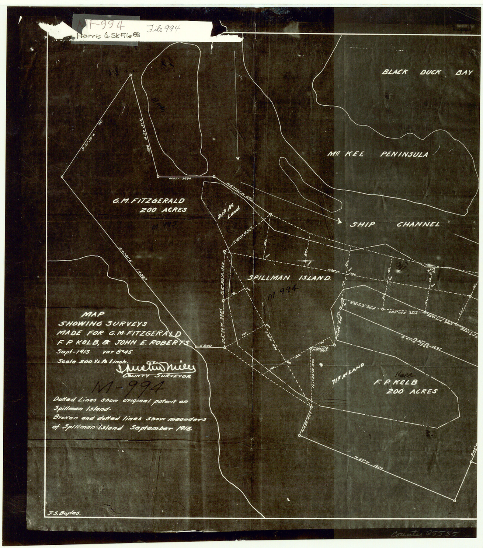
Harris County Sketch File 88
[Copies of plats and field notes from mineral files]
-
Map/Doc
25555
-
Collection
General Map Collection
-
Object Dates
1983/1/6 (File Date)
1913 (Survey Date)
1914/4/28 (Creation Date)
1913/7/31 (Survey Date)
1912 (Survey Date)
1914/3/21 (Correspondence Date)
-
People and Organizations
I. Austin Miller (Surveyor/Engineer)
J.S. Boyles (Draftsman)
J.S. Boyles (Surveyor/Engineer)
Fred Eubanks (Chainman)
George Williford (Chainman)
Jack Lagarde (Chainman)
Arthur A. Stiles (Surveyor/Engineer)
-
Counties
Harris
-
Subjects
Surveying Sketch File
-
Height x Width
13.8 x 12.1 inches
35.1 x 30.7 cm
-
Medium
photostat, negative
-
Scale
1:200; 1:80; 1:400; 1:50
-
Features
Black Duck Bay
McKee Peninsula
Galveston and Houston Ship Channel
Spillman Island
Hog Island
Goose Creek Channel
Goose Creek
Goose Creek Bay
Cedar Bayou
Tabbs Bay
United States Government Ship Channel
San Jacinto Bay
Perkins Island
Gilliard Peninsula
Mullett Island
Morgan Point
Part of: General Map Collection
Potter County Sketch File 9

Print $20.00
- Digital $50.00
Potter County Sketch File 9
1887
Size 12.5 x 17.7 inches
Map/Doc 12198
Lynn County Working Sketch 3

Print $20.00
- Digital $50.00
Lynn County Working Sketch 3
1953
Size 30.8 x 30.9 inches
Map/Doc 70673
Maverick County Sketch File 11

Print $40.00
- Digital $50.00
Maverick County Sketch File 11
1879
Size 8.3 x 8.8 inches
Map/Doc 31092
Layout of the porciones as described in the Visita General of Revilla (Guerrero), 1767, along with six tracts distributed by Gov. Lasaga in 1784 and three others (39-41) assigned at a later date

Layout of the porciones as described in the Visita General of Revilla (Guerrero), 1767, along with six tracts distributed by Gov. Lasaga in 1784 and three others (39-41) assigned at a later date
2009
Size 11.0 x 8.5 inches
Map/Doc 94044
Blanco County Boundary File 1

Print $20.00
- Digital $50.00
Blanco County Boundary File 1
Size 11.6 x 23.1 inches
Map/Doc 50539
Mason County Rolled Sketch 2

Print $20.00
- Digital $50.00
Mason County Rolled Sketch 2
1952
Size 32.9 x 26.7 inches
Map/Doc 6675
Jasper County Working Sketch 30

Print $20.00
- Digital $50.00
Jasper County Working Sketch 30
1956
Size 33.5 x 38.6 inches
Map/Doc 66492
Cottle County Sketch File G

Print $8.00
- Digital $50.00
Cottle County Sketch File G
Size 11.5 x 7.3 inches
Map/Doc 19447
Blanco County Working Sketch 11

Print $3.00
- Digital $50.00
Blanco County Working Sketch 11
1941
Size 10.8 x 10.4 inches
Map/Doc 67371
Culberson County Rolled Sketch 42

Print $20.00
- Digital $50.00
Culberson County Rolled Sketch 42
Size 23.0 x 29.0 inches
Map/Doc 5663
Uvalde County Rolled Sketch 15

Print $20.00
- Digital $50.00
Uvalde County Rolled Sketch 15
1979
Size 26.9 x 23.9 inches
Map/Doc 8099
La Salle County Sketch File 41

Print $20.00
- Digital $50.00
La Salle County Sketch File 41
1918
Size 25.8 x 15.9 inches
Map/Doc 11986
You may also like
Garza County Rolled Sketch 3

Print $2.00
- Digital $50.00
Garza County Rolled Sketch 3
Size 10.0 x 8.1 inches
Map/Doc 75940

Sutton County Working Sketch 15

Print $40.00
- Digital $50.00
Sutton County Working Sketch 15
1972
Size 37.0 x 81.1 inches
Map/Doc 62358

Live Oak County Sketch File 1

Print $4.00
- Digital $50.00
Live Oak County Sketch File 1
1856
Size 11.5 x 7.8 inches
Map/Doc 30251
Aransas County Sketch File 37

Print $139.00
- Digital $50.00
Aransas County Sketch File 37
1995
Size 11.1 x 9.1 inches
Map/Doc 13413
Reagan County Working Sketch 19

Print $20.00
- Digital $50.00
Reagan County Working Sketch 19
1954
Size 24.3 x 42.9 inches
Map/Doc 71861
Eastland County Rolled Sketch 24

Print $20.00
- Digital $50.00
Eastland County Rolled Sketch 24
1983
Size 33.5 x 38.0 inches
Map/Doc 8830
[Blks. 8, 10, CC 41, and 32]
![90118, [Blks. 8, 10, CC 41, and 32], Twichell Survey Records](https://historictexasmaps.com/wmedia_w700/maps/90118-1.tif.jpg)
Print $20.00
- Digital $50.00
[Blks. 8, 10, CC 41, and 32]
Size 40.6 x 15.4 inches
Map/Doc 90118
Parker County Sketch File 15

Print $4.00
- Digital $50.00
Parker County Sketch File 15
1861
Size 8.3 x 8.0 inches
Map/Doc 33548
Right-of-Way & Track Map, Houston & Brazos Valley Ry. operated by Houston & Brazos Valley Ry.

Print $40.00
- Digital $50.00
Right-of-Way & Track Map, Houston & Brazos Valley Ry. operated by Houston & Brazos Valley Ry.
1918
Size 25.0 x 56.3 inches
Map/Doc 64603
Flight Mission No. BQR-9K, Frame 8, Brazoria County

Print $20.00
- Digital $50.00
Flight Mission No. BQR-9K, Frame 8, Brazoria County
1952
Size 18.6 x 22.4 inches
Map/Doc 84037