Presidio County Sketch File 87
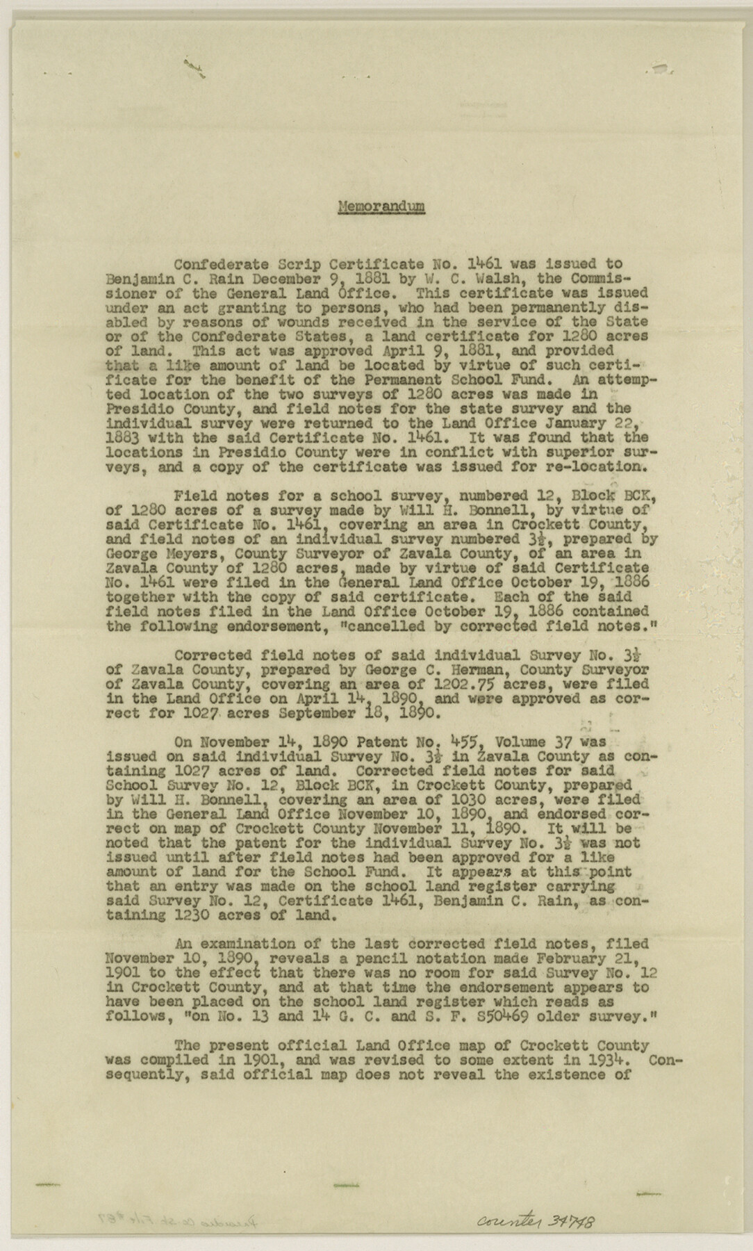
[Memorandum regarding Benjamin C. Rains survey, Bexar Scrip 52156]
-
Map/Doc
34748
-
Collection
General Map Collection
-
Object Dates
10/18/1951 (Creation Date)
10/18/1951 (File Date)
4/14/1890 (File Date)
11/10/1890 (File Date)
1925 (File Date)
1938 (Creation Date)
-
People and Organizations
Dennis Wallace (Surveyor/Engineer)
Will H. Bonnell (Surveyor/Engineer)
George Meyers (Surveyor/Engineer)
George C. Herman (Surveyor/Engineer)
J.O. Barrow (Draftsman)
-
Counties
Presidio Zavala Crockett
-
Subjects
Surveying Sketch File
-
Height x Width
14.5 x 8.7 inches
36.8 x 22.1 cm
-
Medium
paper, print
Part of: General Map Collection
Wichita County Working Sketch 11

Print $20.00
- Digital $50.00
Wichita County Working Sketch 11
1920
Size 32.0 x 18.8 inches
Map/Doc 72520
Ochiltree County Boundary File 5b

Print $4.00
- Digital $50.00
Ochiltree County Boundary File 5b
Size 13.7 x 8.7 inches
Map/Doc 57697
Nueces River, Calallen Sheet

Print $20.00
- Digital $50.00
Nueces River, Calallen Sheet
1927
Size 32.7 x 37.3 inches
Map/Doc 65087
Brooks County Rolled Sketch 25

Print $20.00
- Digital $50.00
Brooks County Rolled Sketch 25
1945
Size 21.6 x 26.4 inches
Map/Doc 5345
Flight Mission No. BRE-2P, Frame 82, Nueces County

Print $20.00
- Digital $50.00
Flight Mission No. BRE-2P, Frame 82, Nueces County
1956
Size 18.5 x 22.6 inches
Map/Doc 86777
Presidio County Working Sketch 34

Print $20.00
- Digital $50.00
Presidio County Working Sketch 34
1947
Size 41.7 x 37.6 inches
Map/Doc 71711
Jasper County Texas

Print $20.00
- Digital $50.00
Jasper County Texas
1879
Size 31.5 x 18.2 inches
Map/Doc 3716
Houston Ship Channel, Alexander Island to Carpenter Bayou

Print $20.00
- Digital $50.00
Houston Ship Channel, Alexander Island to Carpenter Bayou
1975
Size 36.0 x 47.0 inches
Map/Doc 69912
Archer County Working Sketch 17

Print $3.00
- Digital $50.00
Archer County Working Sketch 17
1951
Size 10.7 x 12.2 inches
Map/Doc 67158
Montague County Sketch File 14

Print $4.00
- Digital $50.00
Montague County Sketch File 14
1880
Size 7.8 x 5.4 inches
Map/Doc 31740
Texas 1849: A Lone Star Rising

Print $20.00
- Digital $50.00
Texas 1849: A Lone Star Rising
2000
Size 40.6 x 40.7 inches
Map/Doc 78270
Frio County Working Sketch 16

Print $40.00
- Digital $50.00
Frio County Working Sketch 16
1975
Size 52.7 x 39.4 inches
Map/Doc 69290
You may also like
A New Map of North America

Print $20.00
- Digital $50.00
A New Map of North America
Size 18.5 x 22.2 inches
Map/Doc 95141
Garza County Rolled Sketch 7

Print $11.00
- Digital $50.00
Garza County Rolled Sketch 7
1905
Size 10.0 x 15.4 inches
Map/Doc 45229
Martin County Working Sketch 7

Print $20.00
- Digital $50.00
Martin County Working Sketch 7
1971
Size 43.0 x 31.3 inches
Map/Doc 70825
Starr County Boundary File 44

Print $98.00
- Digital $50.00
Starr County Boundary File 44
Size 8.8 x 12.8 inches
Map/Doc 58818
Runnels County Working Sketch 2

Print $20.00
- Digital $50.00
Runnels County Working Sketch 2
Size 19.8 x 29.4 inches
Map/Doc 63598
Real County Working Sketch 2

Print $20.00
- Digital $50.00
Real County Working Sketch 2
1891
Size 19.7 x 20.6 inches
Map/Doc 71894
Coke County Rolled Sketch 14

Print $20.00
- Digital $50.00
Coke County Rolled Sketch 14
Size 26.8 x 18.9 inches
Map/Doc 5514
Collin County Sketch File 9

Print $4.00
- Digital $50.00
Collin County Sketch File 9
1878
Size 8.3 x 10.1 inches
Map/Doc 18870
Flight Mission No. BQR-9K, Frame 42, Brazoria County

Print $20.00
- Digital $50.00
Flight Mission No. BQR-9K, Frame 42, Brazoria County
1952
Size 18.6 x 22.2 inches
Map/Doc 84046
Val Verde County Rolled Sketch 39

Print $20.00
- Digital $50.00
Val Verde County Rolled Sketch 39
Size 21.7 x 33.9 inches
Map/Doc 8115
Kimble County Working Sketch 29

Print $20.00
- Digital $50.00
Kimble County Working Sketch 29
1941
Size 24.7 x 15.3 inches
Map/Doc 70097
Starr County Working Sketch 20

Print $20.00
- Digital $50.00
Starr County Working Sketch 20
1982
Size 29.5 x 35.2 inches
Map/Doc 63936