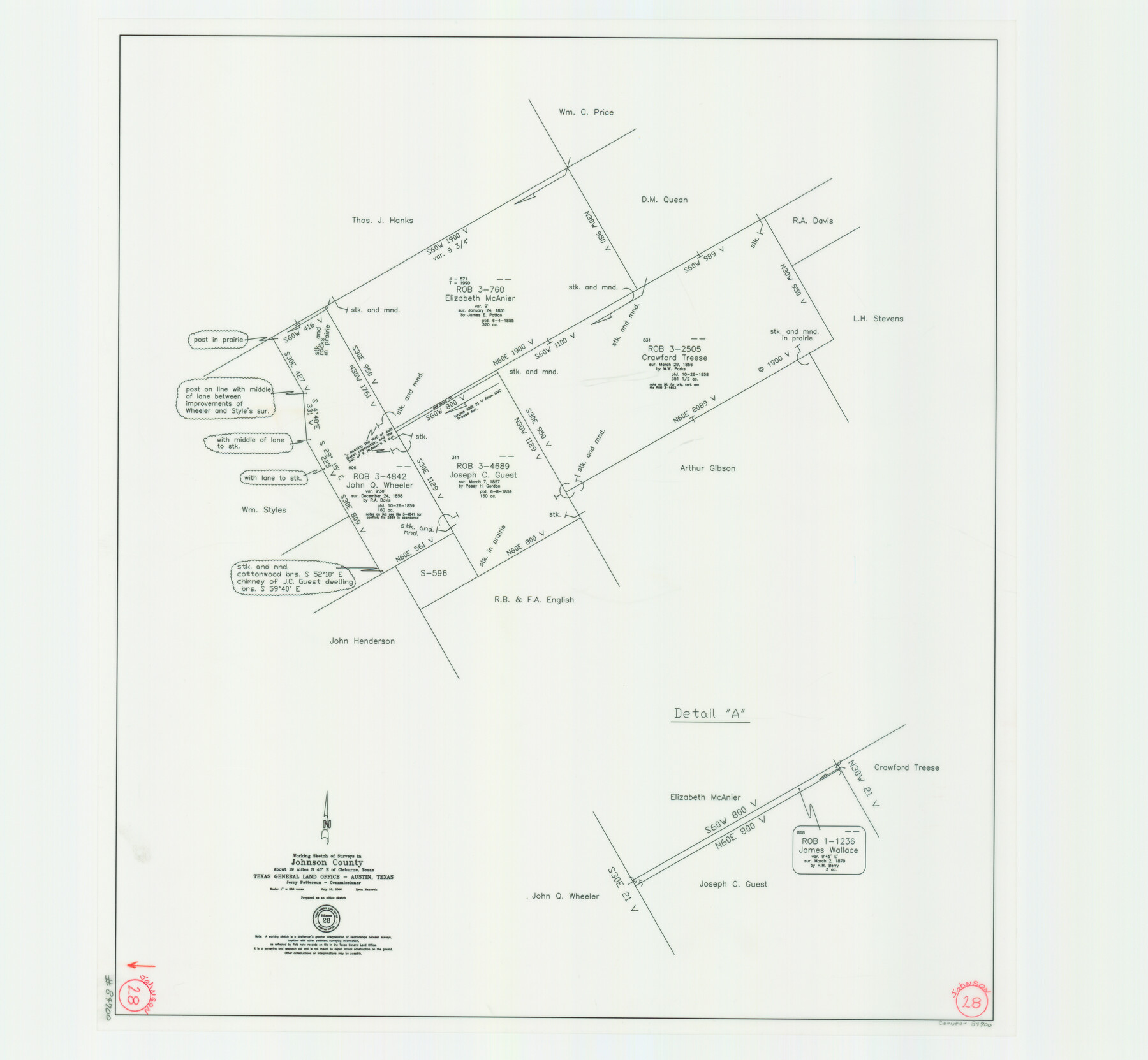
Johnson County Working Sketch 28
-
Map/Doc
84700
-
Collection
General Map Collection
-
Object Dates
7/10/2005 (Creation Date)
-
People and Organizations
Jerry E. Patterson (GLO Commissioner)
Ryan Hancock (Draftsman)
-
Counties
Johnson
-
Subjects
Surveying Working Sketch
-
Height x Width
24.0 x 26.0 inches
61.0 x 66.0 cm
-
Scale
1" = 300 varas
-
Comments
Survey located about 19 miles North 45 degrees East of Cleburne, Texas.
Part of: General Map Collection
Live Oak County Sketch File 20

Print $14.00
- Digital $50.00
Live Oak County Sketch File 20
1898
Size 11.4 x 8.8 inches
Map/Doc 30290

Upshur County Rolled Sketch 4

Print $20.00
- Digital $50.00
Upshur County Rolled Sketch 4
1972
Size 25.4 x 37.9 inches
Map/Doc 8063
Denton County Sketch File 15

Print $8.00
- Digital $50.00
Denton County Sketch File 15
1857
Size 13.1 x 8.2 inches
Map/Doc 20724
Robertson County Rolled Sketch 6

Print $20.00
- Digital $50.00
Robertson County Rolled Sketch 6
Size 22.8 x 15.6 inches
Map/Doc 7512
Williamson County

Print $40.00
- Digital $50.00
Williamson County
1946
Size 38.7 x 56.8 inches
Map/Doc 95676
Young County Rolled Sketch 19

Print $20.00
- Digital $50.00
Young County Rolled Sketch 19
2021
Size 24.3 x 30.4 inches
Map/Doc 97023
Stonewall County Sketch File 28

Print $14.00
- Digital $50.00
Stonewall County Sketch File 28
1970
Size 14.3 x 8.9 inches
Map/Doc 37300
Flight Mission No. CRK-8P, Frame 118, Refugio County

Print $20.00
- Digital $50.00
Flight Mission No. CRK-8P, Frame 118, Refugio County
1956
Size 18.3 x 22.1 inches
Map/Doc 86973
Flight Mission No. DQN-3K, Frame 12, Calhoun County

Print $20.00
- Digital $50.00
Flight Mission No. DQN-3K, Frame 12, Calhoun County
1953
Size 18.8 x 22.4 inches
Map/Doc 84344
Harris County NRC Article 33.136 Sketch 12

Print $30.00
- Digital $50.00
Harris County NRC Article 33.136 Sketch 12
2007
Size 24.0 x 17.5 inches
Map/Doc 94627
Montague County Sketch File 12

Print $4.00
- Digital $50.00
Montague County Sketch File 12
Size 11.4 x 8.2 inches
Map/Doc 31736
You may also like
Kimble County Working Sketch 37

Print $20.00
- Digital $50.00
Kimble County Working Sketch 37
1946
Size 34.3 x 20.6 inches
Map/Doc 70105
Real County Rolled Sketch 12

Print $40.00
- Digital $50.00
Real County Rolled Sketch 12
Size 42.7 x 54.6 inches
Map/Doc 9836
Frio County Working Sketch 10

Print $20.00
- Digital $50.00
Frio County Working Sketch 10
1951
Size 27.0 x 27.3 inches
Map/Doc 69284
Fannin County Sketch File 25

Print $4.00
- Digital $50.00
Fannin County Sketch File 25
1847
Size 8.5 x 10.9 inches
Map/Doc 22493
Comanche County Working Sketch 24

Print $20.00
- Digital $50.00
Comanche County Working Sketch 24
1975
Size 29.8 x 33.4 inches
Map/Doc 68158
[Map of Zalsamora Pasture and surrounding area]
![408, [Map of Zalsamora Pasture and surrounding area], Maddox Collection](https://historictexasmaps.com/wmedia_w700/maps/408.tif.jpg)
Print $20.00
- Digital $50.00
[Map of Zalsamora Pasture and surrounding area]
Size 33.3 x 24.4 inches
Map/Doc 408
Pecos County Rolled Sketch 91

Print $20.00
- Digital $50.00
Pecos County Rolled Sketch 91
Size 23.6 x 34.7 inches
Map/Doc 9710
Bosque County Sketch File 25

Print $4.00
- Digital $50.00
Bosque County Sketch File 25
Size 12.7 x 8.1 inches
Map/Doc 14809
Lavaca County Rolled Sketch 8

Print $40.00
- Digital $50.00
Lavaca County Rolled Sketch 8
1982
Size 36.5 x 65.6 inches
Map/Doc 10289
Harris County Working Sketch 30

Print $20.00
- Digital $50.00
Harris County Working Sketch 30
1935
Size 25.9 x 28.0 inches
Map/Doc 65922
Jasper County Working Sketch 5

Print $20.00
- Digital $50.00
Jasper County Working Sketch 5
1906
Size 26.8 x 38.0 inches
Map/Doc 66467
