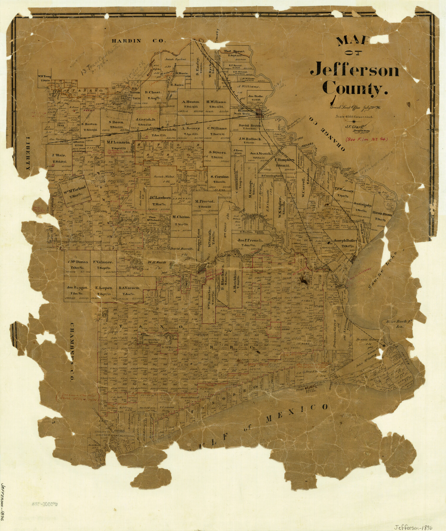
Map of Jefferson County
-
Map/Doc
3731
-
Collection
General Map Collection
-
Object Dates
7/22/1896 (Creation Date)
-
People and Organizations
J.F. Clark (Draftsman)
-
Counties
Jefferson
-
Subjects
County
-
Height x Width
25.3 x 21.6 inches
64.3 x 54.9 cm
-
Features
S&ET
Big Hill
Mayhaw Bayou
Round Lake
Blue Buck Point Lake
Sabine Pass
Blue Buck Point
Blue Buck Lake
Gulf of Mexico
North Fork of Taylors Bayou
GB & KC
SPRR
Sour Lake Station
Alligator Bayou
Mud Bayou
Big Hill
Sabine City
T&NO
Cotton Creek
Pine Island Bayou
S&ET
GB&KC
Neches River
Beaumont
KCP&G
Double Point Bayou
Willow Marsh Bayou
Pine Island Station
China Station
Bayou Din
Hillibrand Bayou
Sabine Lake
Port Arthur
Taylors Bayou
Part of: General Map Collection
Terrell County Working Sketch 84a

Print $20.00
- Digital $50.00
Terrell County Working Sketch 84a
1992
Size 34.5 x 37.0 inches
Map/Doc 69605
Hudspeth County Sketch File 25

Print $10.00
- Digital $50.00
Hudspeth County Sketch File 25
1936
Size 11.3 x 8.7 inches
Map/Doc 26979
Trinity County Sketch File 26

Print $8.00
- Digital $50.00
Trinity County Sketch File 26
1885
Size 13.1 x 8.4 inches
Map/Doc 38558
Garza County Boundary File 3

Print $76.00
- Digital $50.00
Garza County Boundary File 3
Size 11.4 x 9.0 inches
Map/Doc 53683
United States - Gulf Coast - Padre I. and Laguna Madre Lat. 27° 12' to Lat. 26° 33' Texas

Print $20.00
- Digital $50.00
United States - Gulf Coast - Padre I. and Laguna Madre Lat. 27° 12' to Lat. 26° 33' Texas
1913
Size 27.0 x 18.3 inches
Map/Doc 72819
Llano County Sketch File 10

Print $10.00
- Digital $50.00
Llano County Sketch File 10
1886
Size 8.2 x 7.6 inches
Map/Doc 30370

McCulloch County Sketch File 8

Print $4.00
- Digital $50.00
McCulloch County Sketch File 8
1904
Size 11.3 x 8.7 inches
Map/Doc 31182
Brewster County Sketch File 43

Print $4.00
- Digital $50.00
Brewster County Sketch File 43
Size 8.8 x 11.3 inches
Map/Doc 16309
Live Oak County Working Sketch 1

Print $20.00
- Digital $50.00
Live Oak County Working Sketch 1
Size 20.4 x 29.1 inches
Map/Doc 70586
Galveston County NRC Article 33.136 Sketch 36

Print $28.00
- Digital $50.00
Galveston County NRC Article 33.136 Sketch 36
2005
Size 24.5 x 36.6 inches
Map/Doc 83409
Terrell County Working Sketch 55

Print $20.00
- Digital $50.00
Terrell County Working Sketch 55
1959
Size 25.9 x 43.4 inches
Map/Doc 62148
You may also like
El Paso County Working Sketch 4

Print $20.00
- Digital $50.00
El Paso County Working Sketch 4
1916
Size 21.4 x 37.3 inches
Map/Doc 69026
Phelps & Ensigns Travellers' Guide, and Map of the United States, containing the roads, distances, steam boat and canal routes & c.

Print $40.00
- Digital $50.00
Phelps & Ensigns Travellers' Guide, and Map of the United States, containing the roads, distances, steam boat and canal routes & c.
1844
Map/Doc 97114
Travis County Rolled Sketch 4

Print $20.00
- Digital $50.00
Travis County Rolled Sketch 4
1915
Size 19.7 x 35.6 inches
Map/Doc 8010
Sutton County Sketch File X

Print $24.00
- Digital $50.00
Sutton County Sketch File X
1915
Size 14.3 x 8.8 inches
Map/Doc 37451
Garza County Rolled Sketch 6E

Print $20.00
- Digital $50.00
Garza County Rolled Sketch 6E
1913
Size 19.2 x 15.6 inches
Map/Doc 5999
Harris County Sketch File 23

Print $4.00
- Digital $50.00
Harris County Sketch File 23
Size 8.5 x 6.2 inches
Map/Doc 25377
Brewster County Sketch File N-1

Print $40.00
- Digital $50.00
Brewster County Sketch File N-1
Size 16.6 x 22.1 inches
Map/Doc 10961
Map of Young County

Print $20.00
- Digital $50.00
Map of Young County
1897
Size 44.1 x 37.9 inches
Map/Doc 63140
University of Texas System University Lands

Print $20.00
- Digital $50.00
University of Texas System University Lands
Size 17.9 x 23.3 inches
Map/Doc 93244
[West Part of Labor 18]
![91006, [West Part of Labor 18], Twichell Survey Records](https://historictexasmaps.com/wmedia_w700/maps/91006-1.tif.jpg)
Print $20.00
- Digital $50.00
[West Part of Labor 18]
Size 18.9 x 19.4 inches
Map/Doc 91006

Sabine Pass, Texas

Print $40.00
- Digital $50.00
Sabine Pass, Texas
1874
Size 32.2 x 53.2 inches
Map/Doc 69837