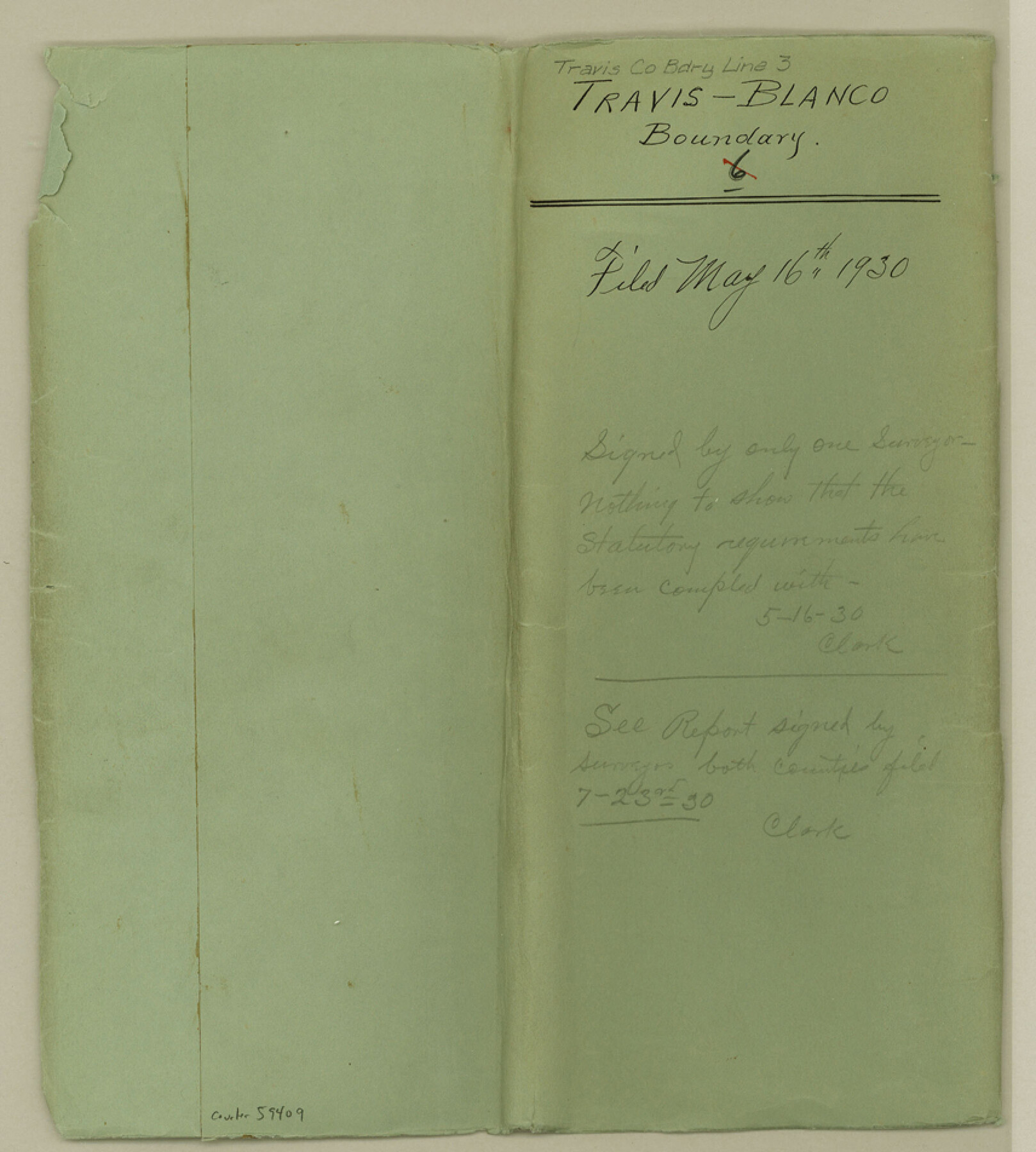
Travis County Boundary File 3
Map showing resurvey of the Travis-Blanco County Line from SE corner of Burnet County to NW corner of Hays County
-
Map/Doc
59409
-
Collection
General Map Collection
-
Counties
Travis
-
Subjects
County Boundaries
-
Height x Width
9.5 x 8.6 inches
24.1 x 21.8 cm
Part of: General Map Collection
Cottle County Sketch File KN

Print $20.00
- Digital $50.00
Cottle County Sketch File KN
Size 18.8 x 25.2 inches
Map/Doc 11203
Montgomery County Rolled Sketch 40A

Print $40.00
- Digital $50.00
Montgomery County Rolled Sketch 40A
1970
Size 40.4 x 57.5 inches
Map/Doc 9547
Brewster County Rolled Sketch 79

Print $20.00
- Digital $50.00
Brewster County Rolled Sketch 79
Size 36.9 x 28.0 inches
Map/Doc 5244
Angelina County Sketch File 15b

Print $8.00
- Digital $50.00
Angelina County Sketch File 15b
1863
Size 12.7 x 7.9 inches
Map/Doc 12968
Callahan County Working Sketch 7

Print $20.00
- Digital $50.00
Callahan County Working Sketch 7
1955
Size 25.1 x 12.7 inches
Map/Doc 67889
Crockett County Rolled Sketch 78

Print $20.00
- Digital $50.00
Crockett County Rolled Sketch 78
1952
Size 20.5 x 19.5 inches
Map/Doc 5619
Bexar County Boundary File 3

Print $6.00
- Digital $50.00
Bexar County Boundary File 3
Size 8.2 x 3.6 inches
Map/Doc 50536
McMullen County Working Sketch 54

Print $20.00
- Digital $50.00
McMullen County Working Sketch 54
1983
Size 25.3 x 29.0 inches
Map/Doc 70755
Polk County Sketch File 7

Print $6.00
- Digital $50.00
Polk County Sketch File 7
1860
Size 12.1 x 7.9 inches
Map/Doc 34131
Hemphill County Working Sketch 27

Print $40.00
- Digital $50.00
Hemphill County Working Sketch 27
1974
Size 50.7 x 43.5 inches
Map/Doc 66122
Terrell County Rolled Sketch 59

Print $20.00
- Digital $50.00
Terrell County Rolled Sketch 59
Size 32.5 x 28.2 inches
Map/Doc 7975
Kimble County Sketch File 10

Print $23.00
- Digital $50.00
Kimble County Sketch File 10
Size 18.5 x 15.6 inches
Map/Doc 28931
You may also like
Floyd County Boundary File 2b

Print $40.00
- Digital $50.00
Floyd County Boundary File 2b
Size 38.9 x 20.1 inches
Map/Doc 53490
Flight Mission No. CRC-5R, Frame 22, Chambers County

Print $20.00
- Digital $50.00
Flight Mission No. CRC-5R, Frame 22, Chambers County
1956
Size 18.7 x 22.6 inches
Map/Doc 84944
Jasper County Sketch File 28

Print $10.00
- Digital $50.00
Jasper County Sketch File 28
1947
Size 11.4 x 8.8 inches
Map/Doc 27853
Montgomery County Working Sketch 48

Print $20.00
- Digital $50.00
Montgomery County Working Sketch 48
1958
Size 24.4 x 32.1 inches
Map/Doc 71155
Mitchell County Working Sketch 5

Print $40.00
- Digital $50.00
Mitchell County Working Sketch 5
1956
Size 60.4 x 28.2 inches
Map/Doc 71062
Burleson County Working Sketch 37

Print $20.00
- Digital $50.00
Burleson County Working Sketch 37
1982
Size 33.7 x 44.3 inches
Map/Doc 67756
Victoria County Rolled Sketch 4C

Print $40.00
- Digital $50.00
Victoria County Rolled Sketch 4C
1963
Size 65.0 x 43.3 inches
Map/Doc 10097
Bosque County Working Sketch 1

Print $20.00
- Digital $50.00
Bosque County Working Sketch 1
Size 16.3 x 13.7 inches
Map/Doc 67434
Williamson County

Print $40.00
- Digital $50.00
Williamson County
1888
Size 37.1 x 54.0 inches
Map/Doc 16930
Montague County Working Sketch 1

Print $20.00
- Digital $50.00
Montague County Working Sketch 1
Size 18.7 x 32.5 inches
Map/Doc 71067
Clarke and Courts' Map of Jefferson County and Beaumont and Sour Lake Oil Fields

Print $20.00
Clarke and Courts' Map of Jefferson County and Beaumont and Sour Lake Oil Fields
1901
Size 28.2 x 24.3 inches
Map/Doc 79289
General Highway Map, Refugio County, Texas

Print $20.00
General Highway Map, Refugio County, Texas
1940
Size 18.3 x 25.0 inches
Map/Doc 79228