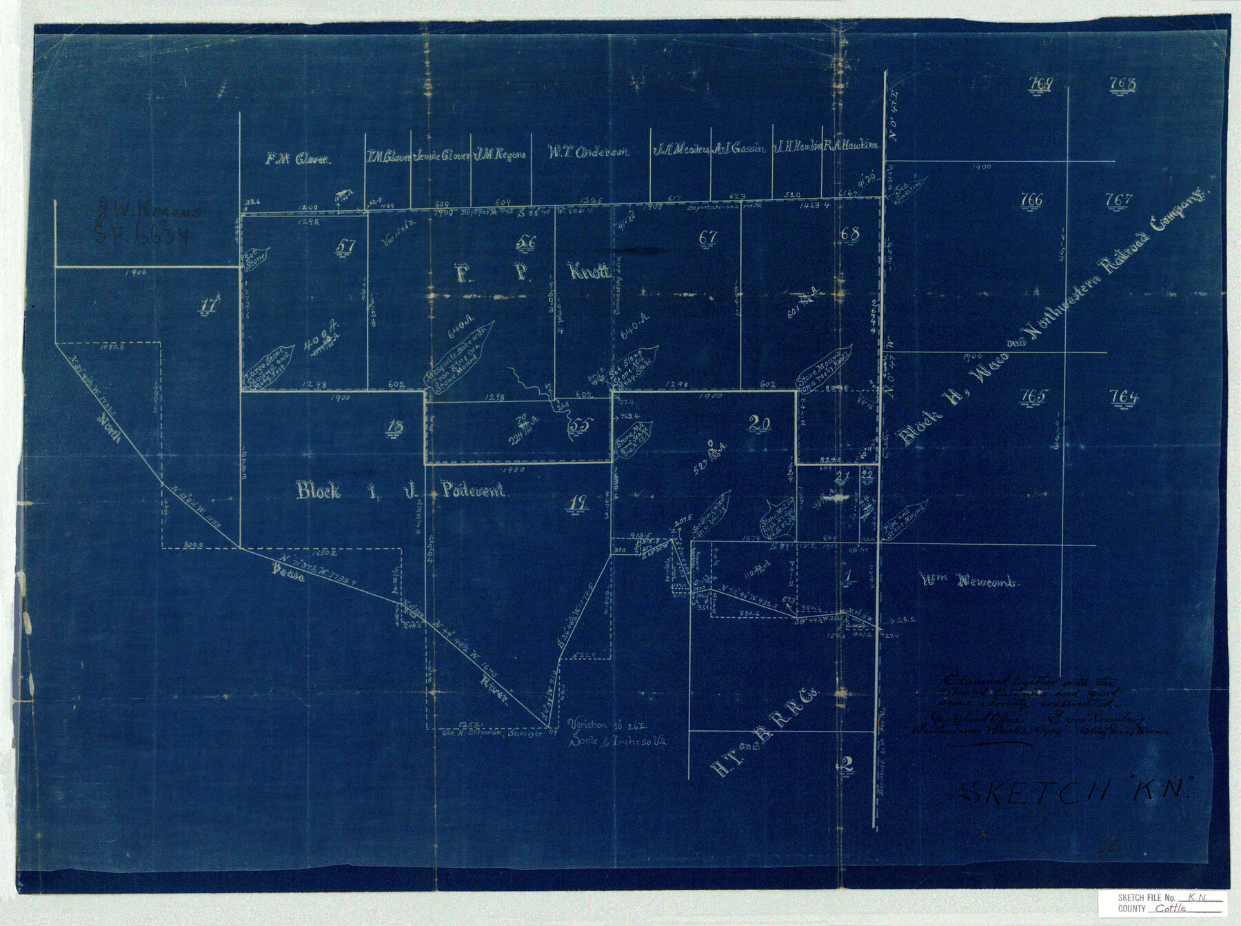
Cottle County Sketch File KN
[Sketch of surveys north of the North Pease River in the northwest part of the county]
-
Map/Doc
11203
-
Collection
General Map Collection
-
Object Dates
3/31/1914 (File Date)
-
People and Organizations
E. von Rosenberg (Draftsman)
-
Counties
Cottle
-
Subjects
Surveying Sketch File
-
Height x Width
18.8 x 25.2 inches
47.8 x 64.0 cm
-
Medium
blueprint/diazo
-
Scale
1" = 50 varas
-
Features
North Pease River
Part of: General Map Collection
Flight Mission No. DQO-7K, Frame 83, Galveston County

Print $20.00
- Digital $50.00
Flight Mission No. DQO-7K, Frame 83, Galveston County
1952
Size 18.8 x 22.5 inches
Map/Doc 85110
Flight Mission No. CRC-3R, Frame 197, Chambers County

Print $20.00
- Digital $50.00
Flight Mission No. CRC-3R, Frame 197, Chambers County
1956
Size 18.5 x 22.3 inches
Map/Doc 84852
Flight Mission No. BRE-2P, Frame 45, Nueces County

Print $20.00
- Digital $50.00
Flight Mission No. BRE-2P, Frame 45, Nueces County
1956
Size 18.6 x 22.6 inches
Map/Doc 86747
Milam County Rolled Sketch 5

Print $20.00
- Digital $50.00
Milam County Rolled Sketch 5
Size 27.9 x 39.8 inches
Map/Doc 6777
Brown County Sketch File 8

Print $4.00
- Digital $50.00
Brown County Sketch File 8
1860
Size 13.4 x 8.1 inches
Map/Doc 16593
Brewster County Rolled Sketch 148B

Print $20.00
- Digital $50.00
Brewster County Rolled Sketch 148B
1994
Size 28.0 x 36.3 inches
Map/Doc 5315
Flight Mission No. CRK-5P, Frame 163, Refugio County

Print $20.00
- Digital $50.00
Flight Mission No. CRK-5P, Frame 163, Refugio County
1956
Size 18.4 x 22.2 inches
Map/Doc 86944
Roberts County Working Sketch 20

Print $20.00
- Digital $50.00
Roberts County Working Sketch 20
1977
Size 25.6 x 32.9 inches
Map/Doc 63546
Flight Mission No. DQO-2K, Frame 146, Galveston County

Print $20.00
- Digital $50.00
Flight Mission No. DQO-2K, Frame 146, Galveston County
1952
Size 18.7 x 22.4 inches
Map/Doc 85043
Aransas County Working Sketch 22

Print $20.00
- Digital $50.00
Aransas County Working Sketch 22
Size 24.3 x 18.2 inches
Map/Doc 67189
[Sketch for Mineral Application 26501 - Sabine River, T. A. Oldhausen]
![2842, [Sketch for Mineral Application 26501 - Sabine River, T. A. Oldhausen], General Map Collection](https://historictexasmaps.com/wmedia_w700/maps/2842.tif.jpg)
Print $20.00
- Digital $50.00
[Sketch for Mineral Application 26501 - Sabine River, T. A. Oldhausen]
1931
Size 24.0 x 36.9 inches
Map/Doc 2842
Flight Mission No. BRA-16M, Frame 89, Jefferson County

Print $20.00
- Digital $50.00
Flight Mission No. BRA-16M, Frame 89, Jefferson County
1953
Size 18.6 x 22.4 inches
Map/Doc 85701
You may also like
Medina County Rolled Sketch 3

Print $40.00
- Digital $50.00
Medina County Rolled Sketch 3
Size 40.9 x 54.5 inches
Map/Doc 9504
Udell -V- Hughes Sketch

Print $20.00
- Digital $50.00
Udell -V- Hughes Sketch
Size 41.6 x 26.7 inches
Map/Doc 90894
Burnet County Sketch File 29

Print $4.00
- Digital $50.00
Burnet County Sketch File 29
1874
Size 10.1 x 8.1 inches
Map/Doc 16744
Hardin County Sketch File 51

Print $9.00
- Digital $50.00
Hardin County Sketch File 51
Size 9.9 x 8.1 inches
Map/Doc 25206
Polk County Sketch File 5

Print $2.00
- Digital $50.00
Polk County Sketch File 5
Size 8.0 x 7.0 inches
Map/Doc 34128
Map of Tom Green Co.

Print $40.00
- Digital $50.00
Map of Tom Green Co.
1880
Size 42.3 x 51.2 inches
Map/Doc 80136
[Strip between Block 8 and Block K4]
![90601, [Strip between Block 8 and Block K4], Twichell Survey Records](https://historictexasmaps.com/wmedia_w700/maps/90601-1.tif.jpg)
Print $2.00
- Digital $50.00
[Strip between Block 8 and Block K4]
Size 8.8 x 11.7 inches
Map/Doc 90601
Hudspeth County Rolled Sketch 76

Print $40.00
- Digital $50.00
Hudspeth County Rolled Sketch 76
1992
Size 49.5 x 37.7 inches
Map/Doc 9239
Tom Green County Sketch File 88

Print $8.00
- Digital $50.00
Tom Green County Sketch File 88
1990
Size 11.5 x 8.9 inches
Map/Doc 38266
Brewster County Rolled Sketch 59D

Print $20.00
- Digital $50.00
Brewster County Rolled Sketch 59D
Size 33.3 x 47.3 inches
Map/Doc 5231
Irion County Rolled Sketch 11

Print $40.00
- Digital $50.00
Irion County Rolled Sketch 11
1945
Size 38.5 x 52.9 inches
Map/Doc 9252
McMullen County Working Sketch 20

Print $20.00
- Digital $50.00
McMullen County Working Sketch 20
1945
Size 34.1 x 29.6 inches
Map/Doc 70721