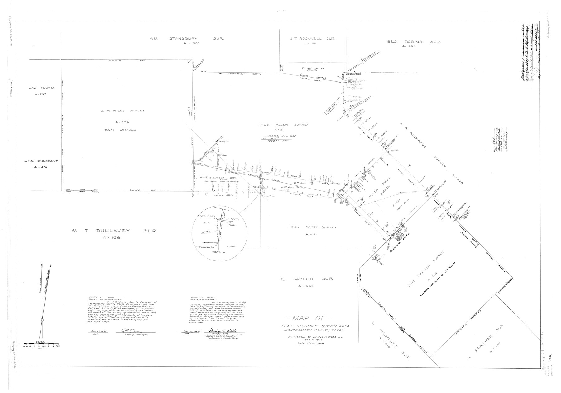
Montgomery County Rolled Sketch 40A
Map of H. & F. Steussey survey area, Montgomery County, Texas
-
Map/Doc
9547
-
Collection
General Map Collection
-
Object Dates
1970/1/16 (Creation Date)
1971/2/22 (File Date)
-
People and Organizations
Irving H. Webb (Surveyor/Engineer)
-
Counties
Montgomery
-
Subjects
Surveying Rolled Sketch
-
Height x Width
40.4 x 57.5 inches
102.6 x 146.1 cm
-
Scale
1" = 200 varas
-
Comments
See Montgomery County Rolled Sketch 40 (46793) for report and additional sketches.
Related maps
Montgomery County Rolled Sketch 40

Print $393.00
- Digital $50.00
Montgomery County Rolled Sketch 40
1970
Size 10.3 x 16.0 inches
Map/Doc 46793
Part of: General Map Collection
Hemphill County Working Sketch 34

Print $40.00
- Digital $50.00
Hemphill County Working Sketch 34
1976
Size 33.9 x 64.2 inches
Map/Doc 66129
Flight Mission No. DQN-1K, Frame 32, Calhoun County

Print $20.00
- Digital $50.00
Flight Mission No. DQN-1K, Frame 32, Calhoun County
1953
Size 18.6 x 22.2 inches
Map/Doc 84137
Harris County Rolled Sketch 88

Print $20.00
- Digital $50.00
Harris County Rolled Sketch 88
1936
Size 35.0 x 22.8 inches
Map/Doc 6125
Hamilton County Sketch File 21

Print $4.00
- Digital $50.00
Hamilton County Sketch File 21
1851
Size 12.9 x 8.2 inches
Map/Doc 24945
Liberty County Rolled Sketch JP

Print $40.00
- Digital $50.00
Liberty County Rolled Sketch JP
Size 43.6 x 70.1 inches
Map/Doc 9566
Atascosa County Working Sketch 11

Print $20.00
- Digital $50.00
Atascosa County Working Sketch 11
1923
Size 13.9 x 17.1 inches
Map/Doc 67207
Kuechler's Corners, Texas & Pacific Ry. Co. 80 Mile Reserve

Print $703.00
- Digital $50.00
Kuechler's Corners, Texas & Pacific Ry. Co. 80 Mile Reserve
1934
Size 11.0 x 8.5 inches
Map/Doc 2248
Coke County Sketch File 19

Print $20.00
- Digital $50.00
Coke County Sketch File 19
Size 18.5 x 25.0 inches
Map/Doc 11110
Orange County Working Sketch 8

Print $20.00
- Digital $50.00
Orange County Working Sketch 8
1922
Size 20.7 x 24.3 inches
Map/Doc 71340
Controlled Mosaic by Jack Amman Photogrammetric Engineers, Inc - Sheet 32

Print $20.00
- Digital $50.00
Controlled Mosaic by Jack Amman Photogrammetric Engineers, Inc - Sheet 32
1954
Size 20.0 x 24.0 inches
Map/Doc 83485

Montague County Working Sketch 8

Print $20.00
- Digital $50.00
Montague County Working Sketch 8
1928
Size 20.9 x 18.9 inches
Map/Doc 71074
You may also like
San Luis Pass to East Matagorda Bay

Print $20.00
- Digital $50.00
San Luis Pass to East Matagorda Bay
1960
Size 34.6 x 46.5 inches
Map/Doc 69963
Flight Mission No. CUG-1P, Frame 170, Kleberg County

Print $20.00
- Digital $50.00
Flight Mission No. CUG-1P, Frame 170, Kleberg County
1956
Size 18.5 x 22.2 inches
Map/Doc 86177
Comanche County Sketch File 26

Print $20.00
- Digital $50.00
Comanche County Sketch File 26
Size 18.0 x 17.5 inches
Map/Doc 11144
[Cotton Belt, St. Louis Southwestern Railway of Texas, Alignment through Smith County]
![64386, [Cotton Belt, St. Louis Southwestern Railway of Texas, Alignment through Smith County], General Map Collection](https://historictexasmaps.com/wmedia_w700/maps/64386.tif.jpg)
Print $20.00
- Digital $50.00
[Cotton Belt, St. Louis Southwestern Railway of Texas, Alignment through Smith County]
1903
Size 21.7 x 29.3 inches
Map/Doc 64386
Bastrop County Working Sketch 9

Print $20.00
- Digital $50.00
Bastrop County Working Sketch 9
1981
Size 44.9 x 43.7 inches
Map/Doc 67309
Plat Section 2, Block B-16

Print $20.00
- Digital $50.00
Plat Section 2, Block B-16
1930
Size 19.0 x 9.8 inches
Map/Doc 90802
Bexar County Sketch File 3

Print $4.00
- Digital $50.00
Bexar County Sketch File 3
Size 12.8 x 8.3 inches
Map/Doc 14473
The Mexican Municipality of Gonzales. Proposed, No Date

Print $20.00
The Mexican Municipality of Gonzales. Proposed, No Date
2020
Size 20.4 x 21.7 inches
Map/Doc 96020
Flight Mission No. BQR-22K, Frame 36, Brazoria County

Print $20.00
- Digital $50.00
Flight Mission No. BQR-22K, Frame 36, Brazoria County
1953
Size 18.6 x 22.4 inches
Map/Doc 84120
Carta Politica

Print $20.00
- Digital $50.00
Carta Politica
1897
Size 26.2 x 34.1 inches
Map/Doc 96797
Maverick County Sketch File 7

Print $15.00
- Digital $50.00
Maverick County Sketch File 7
1878
Size 16.6 x 3.9 inches
Map/Doc 31057
Location of the Southern Kansas Railway of Texas, Carson County, Texas

Print $40.00
- Digital $50.00
Location of the Southern Kansas Railway of Texas, Carson County, Texas
1887
Size 20.5 x 84.3 inches
Map/Doc 64035