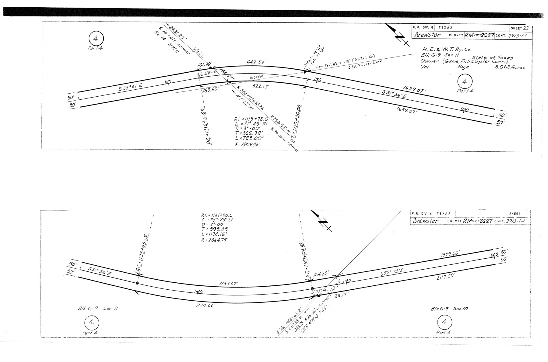
Brewster County Rolled Sketch 114
Plans of proposed State Highway Right of Way, RM Highway 2627, Brewster County, Control 2913-1-1 from: US 383, 38 mi. S of Marathon, SE to: Heath Crossing on Rio Grande (Sheet 22)
-
Map/Doc
5285
-
Collection
General Map Collection
-
Object Dates
1965/3/29 (File Date)
1964/12/3 (Creation Date)
-
People and Organizations
State Highway Department (Publisher)
-
Counties
Brewster
-
Subjects
Surveying Rolled Sketch
-
Height x Width
12.1 x 18.3 inches
30.7 x 46.5 cm
-
Medium
blueprint/diazo
-
Comments
This is one sheet of a set of 29 maps. For the complete set, see map numbers 5264-5292.
Related maps
Brewster County Rolled Sketch 114

Print $20.00
- Digital $50.00
Brewster County Rolled Sketch 114
1964
Size 11.8 x 18.5 inches
Map/Doc 5264
Brewster County Rolled Sketch 114

Print $20.00
- Digital $50.00
Brewster County Rolled Sketch 114
1964
Size 11.7 x 18.4 inches
Map/Doc 5265
Brewster County Rolled Sketch 114

Print $20.00
- Digital $50.00
Brewster County Rolled Sketch 114
1964
Size 11.7 x 18.6 inches
Map/Doc 5266
Brewster County Rolled Sketch 114

Print $20.00
- Digital $50.00
Brewster County Rolled Sketch 114
1964
Size 11.7 x 18.4 inches
Map/Doc 5267
Brewster County Rolled Sketch 114

Print $20.00
- Digital $50.00
Brewster County Rolled Sketch 114
1964
Size 23.8 x 18.9 inches
Map/Doc 5268
Brewster County Rolled Sketch 114

Print $20.00
- Digital $50.00
Brewster County Rolled Sketch 114
1964
Size 11.0 x 18.3 inches
Map/Doc 5269
Brewster County Rolled Sketch 114

Print $20.00
- Digital $50.00
Brewster County Rolled Sketch 114
1964
Size 11.1 x 18.4 inches
Map/Doc 5270
Brewster County Rolled Sketch 114

Print $20.00
- Digital $50.00
Brewster County Rolled Sketch 114
1964
Size 11.5 x 18.5 inches
Map/Doc 5271
Brewster County Rolled Sketch 114

Print $20.00
- Digital $50.00
Brewster County Rolled Sketch 114
1964
Size 11.6 x 18.3 inches
Map/Doc 5272
Brewster County Rolled Sketch 114

Print $20.00
- Digital $50.00
Brewster County Rolled Sketch 114
1964
Size 11.6 x 17.3 inches
Map/Doc 5273
Brewster County Rolled Sketch 114

Print $20.00
- Digital $50.00
Brewster County Rolled Sketch 114
1964
Size 11.5 x 17.6 inches
Map/Doc 5274
Brewster County Rolled Sketch 114

Print $20.00
- Digital $50.00
Brewster County Rolled Sketch 114
1964
Size 11.6 x 18.5 inches
Map/Doc 5275
Brewster County Rolled Sketch 114

Print $20.00
- Digital $50.00
Brewster County Rolled Sketch 114
1964
Size 11.7 x 18.3 inches
Map/Doc 5276
Brewster County Rolled Sketch 114

Print $20.00
- Digital $50.00
Brewster County Rolled Sketch 114
1964
Size 11.4 x 18.4 inches
Map/Doc 5277
Brewster County Rolled Sketch 114

Print $20.00
- Digital $50.00
Brewster County Rolled Sketch 114
1964
Size 12.0 x 18.4 inches
Map/Doc 5278
Brewster County Rolled Sketch 114

Print $20.00
- Digital $50.00
Brewster County Rolled Sketch 114
1964
Size 11.9 x 18.4 inches
Map/Doc 5279
Brewster County Rolled Sketch 114

Print $20.00
- Digital $50.00
Brewster County Rolled Sketch 114
1964
Size 11.9 x 18.3 inches
Map/Doc 5280
Brewster County Rolled Sketch 114

Print $20.00
- Digital $50.00
Brewster County Rolled Sketch 114
1964
Size 11.7 x 17.7 inches
Map/Doc 5281
Brewster County Rolled Sketch 114

Print $20.00
- Digital $50.00
Brewster County Rolled Sketch 114
1964
Size 11.4 x 18.2 inches
Map/Doc 5282
Brewster County Rolled Sketch 114

Print $20.00
- Digital $50.00
Brewster County Rolled Sketch 114
1964
Size 12.2 x 17.5 inches
Map/Doc 5283
Part of: General Map Collection
Taylor County Working Sketch 12

Print $20.00
- Digital $50.00
Taylor County Working Sketch 12
1956
Size 25.5 x 26.9 inches
Map/Doc 69622
Loving County State of Texas

Print $20.00
- Digital $50.00
Loving County State of Texas
1889
Size 20.6 x 24.3 inches
Map/Doc 4582
Flight Mission No. BRA-16M, Frame 83, Jefferson County

Print $20.00
- Digital $50.00
Flight Mission No. BRA-16M, Frame 83, Jefferson County
1953
Size 18.5 x 22.3 inches
Map/Doc 85695
Fort Bend County Working Sketch 32

Print $20.00
- Digital $50.00
Fort Bend County Working Sketch 32
2000
Size 36.5 x 42.5 inches
Map/Doc 69238
Rains County Working Sketch 3

Print $20.00
- Digital $50.00
Rains County Working Sketch 3
1918
Size 22.3 x 12.5 inches
Map/Doc 71829
South Part Brewster Co.

Print $40.00
- Digital $50.00
South Part Brewster Co.
Size 35.2 x 49.8 inches
Map/Doc 66724
Colorado County Sketch File 21

Print $8.00
- Digital $50.00
Colorado County Sketch File 21
Size 13.1 x 8.8 inches
Map/Doc 18957
Liberty County Sketch File 67

Print $28.00
- Digital $50.00
Liberty County Sketch File 67
1996
Size 11.3 x 8.8 inches
Map/Doc 30135
Deaf Smith County Sketch File C

Print $28.00
- Digital $50.00
Deaf Smith County Sketch File C
1902
Size 11.5 x 8.9 inches
Map/Doc 20639
Layout of the porciones as described in the Visita General of Mier, 1767

Layout of the porciones as described in the Visita General of Mier, 1767
2009
Size 11.0 x 8.5 inches
Map/Doc 94043
Bexar County Sketch File 57

Print $4.00
- Digital $50.00
Bexar County Sketch File 57
1847
Size 10.4 x 8.3 inches
Map/Doc 14570
Hamilton County Working Sketch 1

Print $20.00
- Digital $50.00
Hamilton County Working Sketch 1
1914
Size 17.7 x 17.8 inches
Map/Doc 63339
You may also like
[Sketch for Mineral Application 26542 - Sabine River between Prairie and Hawkins Creek, F. B. Jackson, Jr.]
![65670, [Sketch for Mineral Application 26542 - Sabine River between Prairie and Hawkins Creek, F. B. Jackson, Jr.], General Map Collection](https://historictexasmaps.com/wmedia_w700/maps/65670.tif.jpg)
Print $40.00
- Digital $50.00
[Sketch for Mineral Application 26542 - Sabine River between Prairie and Hawkins Creek, F. B. Jackson, Jr.]
1931
Size 64.4 x 21.0 inches
Map/Doc 65670
Loving County Rolled Sketch 14

Print $20.00
- Digital $50.00
Loving County Rolled Sketch 14
2006
Size 11.4 x 17.5 inches
Map/Doc 93381
Leon County Rolled Sketch 8

Print $97.00
- Digital $50.00
Leon County Rolled Sketch 8
1955
Size 32.5 x 31.9 inches
Map/Doc 9429
Trinity County Sketch File 5a

Print $4.00
- Digital $50.00
Trinity County Sketch File 5a
1853
Size 6.9 x 8.0 inches
Map/Doc 38504
El Paso County Working Sketch 21

Print $20.00
- Digital $50.00
El Paso County Working Sketch 21
1960
Size 37.8 x 30.9 inches
Map/Doc 69043
Plan of the City of Galveston, Texas

Print $20.00
- Digital $50.00
Plan of the City of Galveston, Texas
1845
Size 18.2 x 27.7 inches
Map/Doc 62967
McCulloch County

Print $20.00
- Digital $50.00
McCulloch County
1949
Size 47.0 x 35.8 inches
Map/Doc 73234
Hutchinson County Working Sketch Graphic Index - sheet 2

Print $20.00
- Digital $50.00
Hutchinson County Working Sketch Graphic Index - sheet 2
1922
Size 43.8 x 36.7 inches
Map/Doc 76587
Webb County Rolled Sketch 62

Print $20.00
- Digital $50.00
Webb County Rolled Sketch 62
1947
Size 25.2 x 27.4 inches
Map/Doc 8212
Baylor County Sketch File 3

Print $4.00
- Digital $50.00
Baylor County Sketch File 3
1856
Size 12.4 x 8.5 inches
Map/Doc 14124
Hockley County Sketch File 3

Print $20.00
- Digital $50.00
Hockley County Sketch File 3
Size 43.1 x 35.4 inches
Map/Doc 10490
Carson County Boundary File 4

Print $4.00
- Digital $50.00
Carson County Boundary File 4
Size 9.6 x 6.2 inches
Map/Doc 51132