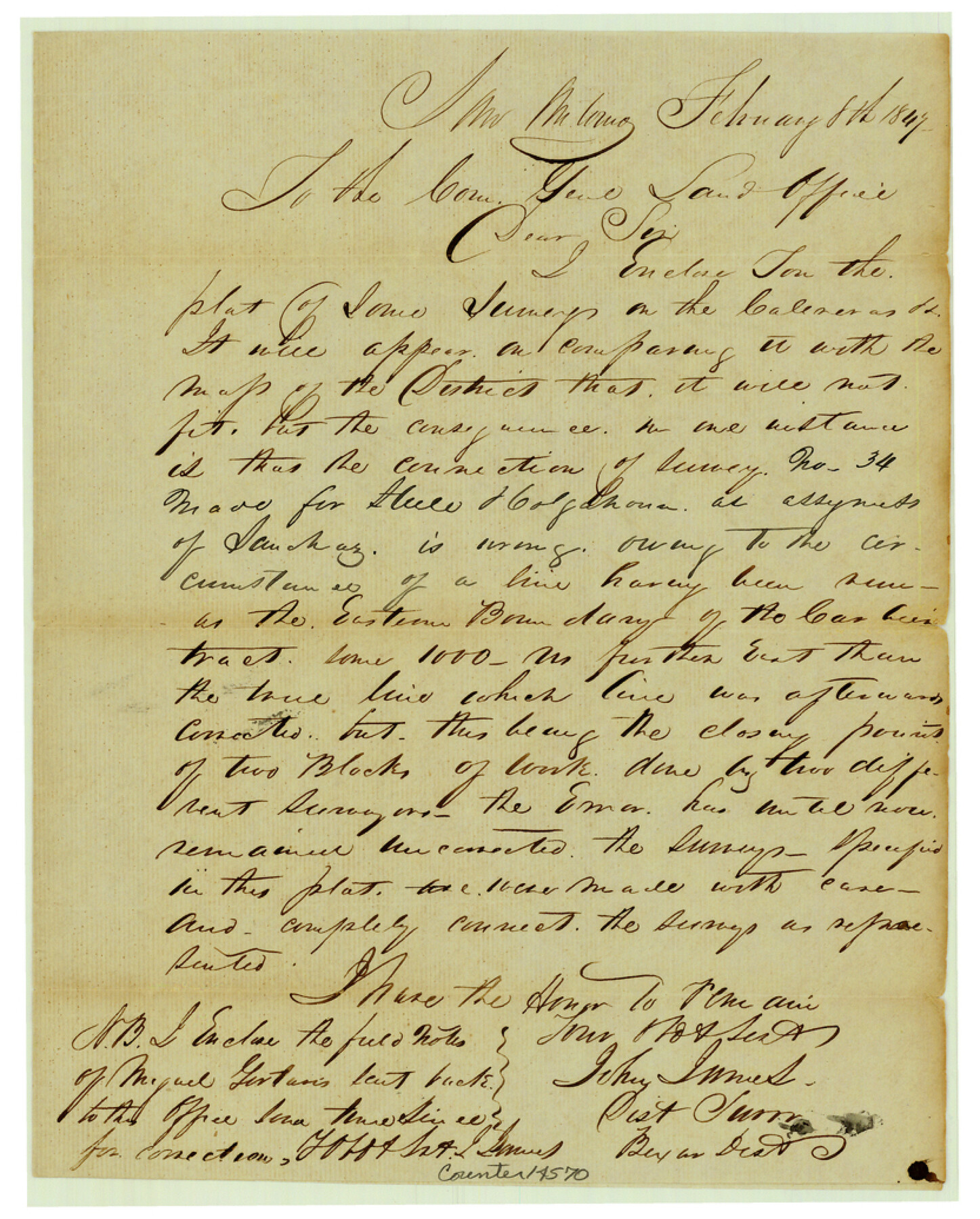
Bexar County Sketch File 57
[Letter from John James to GLO Commissioner regarding lands near Calaveras Creek]
-
Map/Doc
14570
-
Collection
General Map Collection
-
Object Dates
1847/2/8 (Creation Date)
1984/12/7 (File Date)
-
People and Organizations
John James (Surveyor/Engineer)
-
Counties
Bexar
-
Subjects
Surveying Sketch File
-
Height x Width
10.4 x 8.3 inches
26.4 x 21.1 cm
-
Medium
paper, manuscript
-
Features
Caleveras Creek
Part of: General Map Collection
[Map of] North America
![88884, [Map of] North America, General Map Collection](https://historictexasmaps.com/wmedia_w700/maps/88884.tif.jpg)
Print $3.00
- Digital $50.00
[Map of] North America
1834
Size 11.0 x 8.5 inches
Map/Doc 88884
Galveston County NRC Article 33.136 Sketch 46

Print $23.00
- Digital $50.00
Galveston County NRC Article 33.136 Sketch 46
2007
Size 24.6 x 36.0 inches
Map/Doc 87936
Boundary Between U.S. - Mexico, 1853

Print $20.00
- Digital $50.00
Boundary Between U.S. - Mexico, 1853
1954
Size 24.3 x 18.4 inches
Map/Doc 65416
Brazoria County Working Sketch 23

Print $20.00
- Digital $50.00
Brazoria County Working Sketch 23
1961
Size 37.9 x 32.4 inches
Map/Doc 67508
Map and Profile of the Denison and Pacific Railway from Denison to Whitesboro

Print $40.00
- Digital $50.00
Map and Profile of the Denison and Pacific Railway from Denison to Whitesboro
1878
Size 42.5 x 57.5 inches
Map/Doc 64284
Galveston County Rolled Sketch US

Print $20.00
- Digital $50.00
Galveston County Rolled Sketch US
1929
Size 27.6 x 44.6 inches
Map/Doc 9087
San Jacinto County Sketch File 23

Print $26.00
San Jacinto County Sketch File 23
1993
Size 14.6 x 8.8 inches
Map/Doc 35803
Live Oak County Sketch File 23

Print $20.00
- Digital $50.00
Live Oak County Sketch File 23
1910
Size 22.6 x 19.6 inches
Map/Doc 12009
Map of Concho County

Print $20.00
- Digital $50.00
Map of Concho County
1897
Size 47.0 x 39.5 inches
Map/Doc 4733
Lipscomb County Boundary File 14

Print $62.00
- Digital $50.00
Lipscomb County Boundary File 14
Size 13.3 x 8.8 inches
Map/Doc 56355
Motley County Sketch File 7a (S)

Print $5.00
- Digital $50.00
Motley County Sketch File 7a (S)
1895
Size 9.6 x 8.8 inches
Map/Doc 32151
Township 1 North Range 11 West, North Western District, Louisiana

Print $20.00
- Digital $50.00
Township 1 North Range 11 West, North Western District, Louisiana
1884
Size 19.6 x 24.7 inches
Map/Doc 65878
You may also like
Rusk County Sketch File 40

Print $20.00
Rusk County Sketch File 40
1951
Size 23.2 x 26.6 inches
Map/Doc 12276
Midland County Boundary File 2

Print $24.00
- Digital $50.00
Midland County Boundary File 2
Size 8.9 x 5.5 inches
Map/Doc 57162

Brewster County Sketch File NS-6

Print $40.00
- Digital $50.00
Brewster County Sketch File NS-6
1944
Size 31.8 x 18.6 inches
Map/Doc 10989
Montague County Working Sketch Graphic Index

Print $20.00
- Digital $50.00
Montague County Working Sketch Graphic Index
1924
Size 45.3 x 33.2 inches
Map/Doc 76645
Houston County Sketch File 40

Print $40.00
- Digital $50.00
Houston County Sketch File 40
Size 16.3 x 12.1 inches
Map/Doc 26826
Laguna Madre from Lone Palmetto Triangulation Station to Gum Pen Triangulation Station

Print $20.00
- Digital $50.00
Laguna Madre from Lone Palmetto Triangulation Station to Gum Pen Triangulation Station
1881
Size 16.2 x 27.5 inches
Map/Doc 73497
Upshur County Working Sketch 15, revised

Print $20.00
- Digital $50.00
Upshur County Working Sketch 15, revised
1996
Size 43.3 x 37.4 inches
Map/Doc 78217
Flight Mission No. DCL-7C, Frame 57, Kenedy County

Print $20.00
- Digital $50.00
Flight Mission No. DCL-7C, Frame 57, Kenedy County
1943
Size 15.4 x 15.2 inches
Map/Doc 86045
Hutchinson County Sketch File 46

Print $50.00
- Digital $50.00
Hutchinson County Sketch File 46
1981
Size 11.2 x 8.7 inches
Map/Doc 27365
[Block H, E. L. & R. R. Block C-41, and Public School Lands]
![91386, [Block H, E. L. & R. R. Block C-41, and Public School Lands], Twichell Survey Records](https://historictexasmaps.com/wmedia_w700/maps/91386-1.tif.jpg)
Print $20.00
- Digital $50.00
[Block H, E. L. & R. R. Block C-41, and Public School Lands]
1951
Size 24.5 x 18.4 inches
Map/Doc 91386
Aransas County Rolled Sketch 7A

Print $20.00
- Digital $50.00
Aransas County Rolled Sketch 7A
1954
Size 30.5 x 37.6 inches
Map/Doc 76009