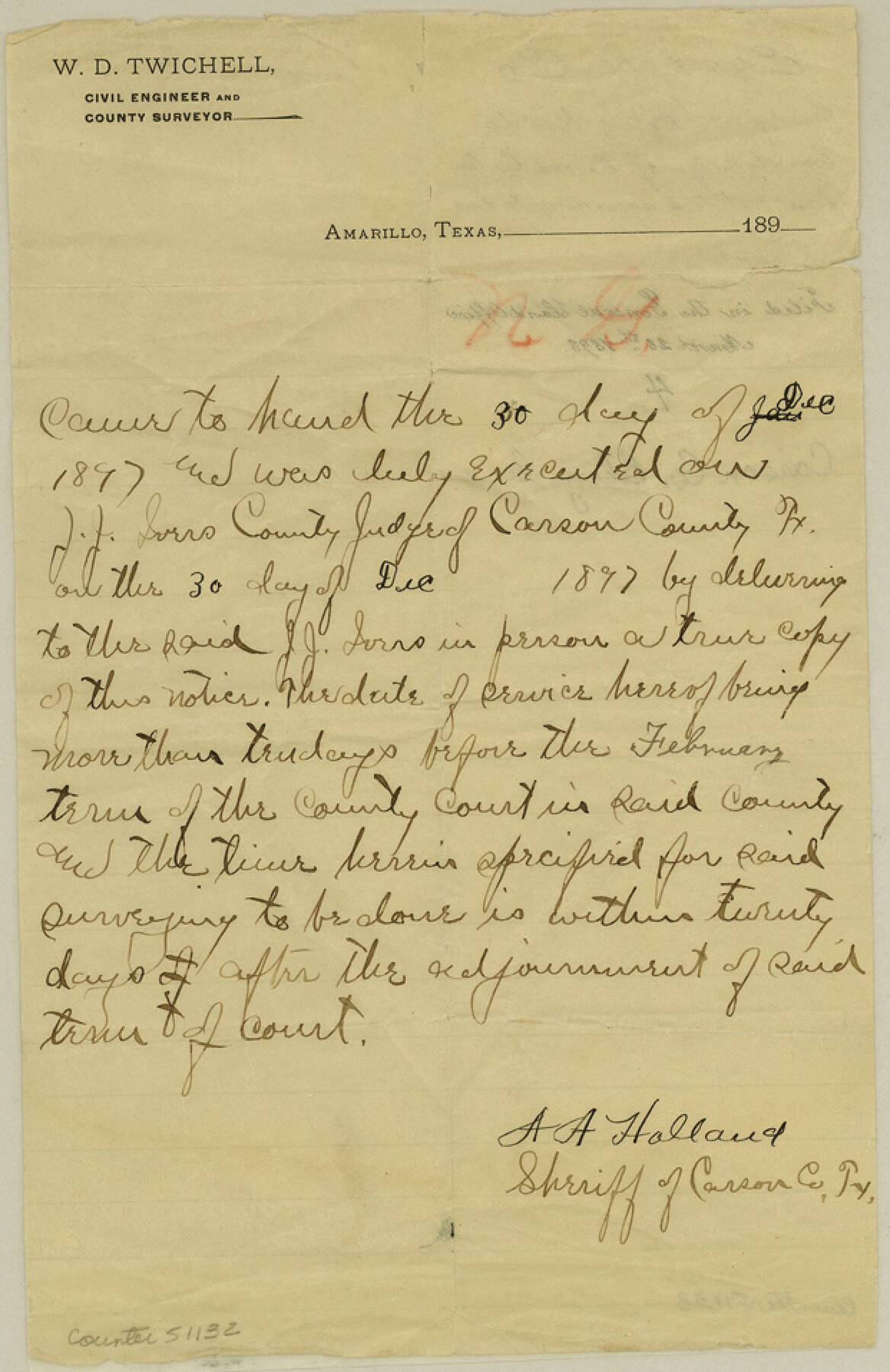
Carson County Boundary File 4
Certificate stating that the County Judge of Carson Co. has been notified according to law
-
Map/Doc
51132
-
Collection
General Map Collection
-
Counties
Carson
-
Subjects
County Boundaries
-
Height x Width
9.6 x 6.2 inches
24.4 x 15.8 cm
Part of: General Map Collection
[Sketch for Mineral Application 24072, San Jacinto River]
![65597, [Sketch for Mineral Application 24072, San Jacinto River], General Map Collection](https://historictexasmaps.com/wmedia_w700/maps/65597.tif.jpg)
Print $20.00
- Digital $50.00
[Sketch for Mineral Application 24072, San Jacinto River]
1929
Size 24.6 x 18.4 inches
Map/Doc 65597
Val Verde County Sketch File 55

Print $44.00
- Digital $50.00
Val Verde County Sketch File 55
1999
Size 11.5 x 8.9 inches
Map/Doc 39337
Morris County Working Sketch 6

Print $20.00
- Digital $50.00
Morris County Working Sketch 6
1985
Size 35.8 x 36.7 inches
Map/Doc 71205
McLennan County

Print $20.00
- Digital $50.00
McLennan County
1946
Size 42.3 x 45.1 inches
Map/Doc 77362
Flight Mission No. BQY-15M, Frame 17, Harris County

Print $20.00
- Digital $50.00
Flight Mission No. BQY-15M, Frame 17, Harris County
1953
Size 18.5 x 22.2 inches
Map/Doc 85315
Kimble County Rolled Sketch 42

Print $20.00
- Digital $50.00
Kimble County Rolled Sketch 42
1995
Size 37.7 x 47.8 inches
Map/Doc 9341
Gaines County Rolled Sketch 29

Print $20.00
- Digital $50.00
Gaines County Rolled Sketch 29
1990
Size 14.7 x 20.5 inches
Map/Doc 5942
Tarrant County Sketch File 32

Print $16.00
- Digital $50.00
Tarrant County Sketch File 32
1946
Size 11.3 x 8.8 inches
Map/Doc 37751
Montgomery County Sketch File 13

Print $40.00
- Digital $50.00
Montgomery County Sketch File 13
1900
Size 17.8 x 14.8 inches
Map/Doc 31803
Pecos County Working Sketch 13

Print $20.00
- Digital $50.00
Pecos County Working Sketch 13
1912
Size 24.2 x 35.3 inches
Map/Doc 71483
Crosby County Sketch File 35

Print $4.00
- Digital $50.00
Crosby County Sketch File 35
Size 8.5 x 12.1 inches
Map/Doc 20106
Edwards County Working Sketch 65

Print $20.00
- Digital $50.00
Edwards County Working Sketch 65
1956
Size 34.0 x 25.0 inches
Map/Doc 68941
You may also like
The Coast of Texas

Print $20.00
- Digital $50.00
The Coast of Texas
1844
Size 18.3 x 26.9 inches
Map/Doc 72697
Tyler County Working Sketch 2

Print $20.00
- Digital $50.00
Tyler County Working Sketch 2
1915
Size 17.5 x 10.4 inches
Map/Doc 69472
Travis County Sketch File 3

Print $4.00
- Digital $50.00
Travis County Sketch File 3
Size 12.9 x 7.9 inches
Map/Doc 38273
Nueces County Sketch File 26a

Print $14.00
- Digital $50.00
Nueces County Sketch File 26a
1894
Size 12.6 x 7.9 inches
Map/Doc 32581
Shackelford County Working Sketch 2

Print $20.00
- Digital $50.00
Shackelford County Working Sketch 2
1914
Size 17.2 x 17.3 inches
Map/Doc 63842
Bowie County Working Sketch 3

Print $20.00
- Digital $50.00
Bowie County Working Sketch 3
1913
Size 25.5 x 17.1 inches
Map/Doc 67407
Block 2 T. & N. Ry. Co., Block 97 H. T. C. Ry. Co.

Print $40.00
- Digital $50.00
Block 2 T. & N. Ry. Co., Block 97 H. T. C. Ry. Co.
1888
Size 41.5 x 48.1 inches
Map/Doc 89874
Maverick County Sketch File 17

Print $20.00
- Digital $50.00
Maverick County Sketch File 17
Size 15.4 x 18.2 inches
Map/Doc 12052
Flight Mission No. DAG-22K, Frame 75, Matagorda County

Print $20.00
- Digital $50.00
Flight Mission No. DAG-22K, Frame 75, Matagorda County
1953
Size 18.5 x 22.3 inches
Map/Doc 86462
Shelby County Working Sketch 18

Print $20.00
- Digital $50.00
Shelby County Working Sketch 18
1957
Size 20.7 x 27.4 inches
Map/Doc 63871
Hansford County

Print $20.00
- Digital $50.00
Hansford County
1902
Size 38.8 x 34.9 inches
Map/Doc 4696
Pecos County Rolled Sketch 18

Print $20.00
- Digital $50.00
Pecos County Rolled Sketch 18
1882
Size 34.4 x 44.1 inches
Map/Doc 9683