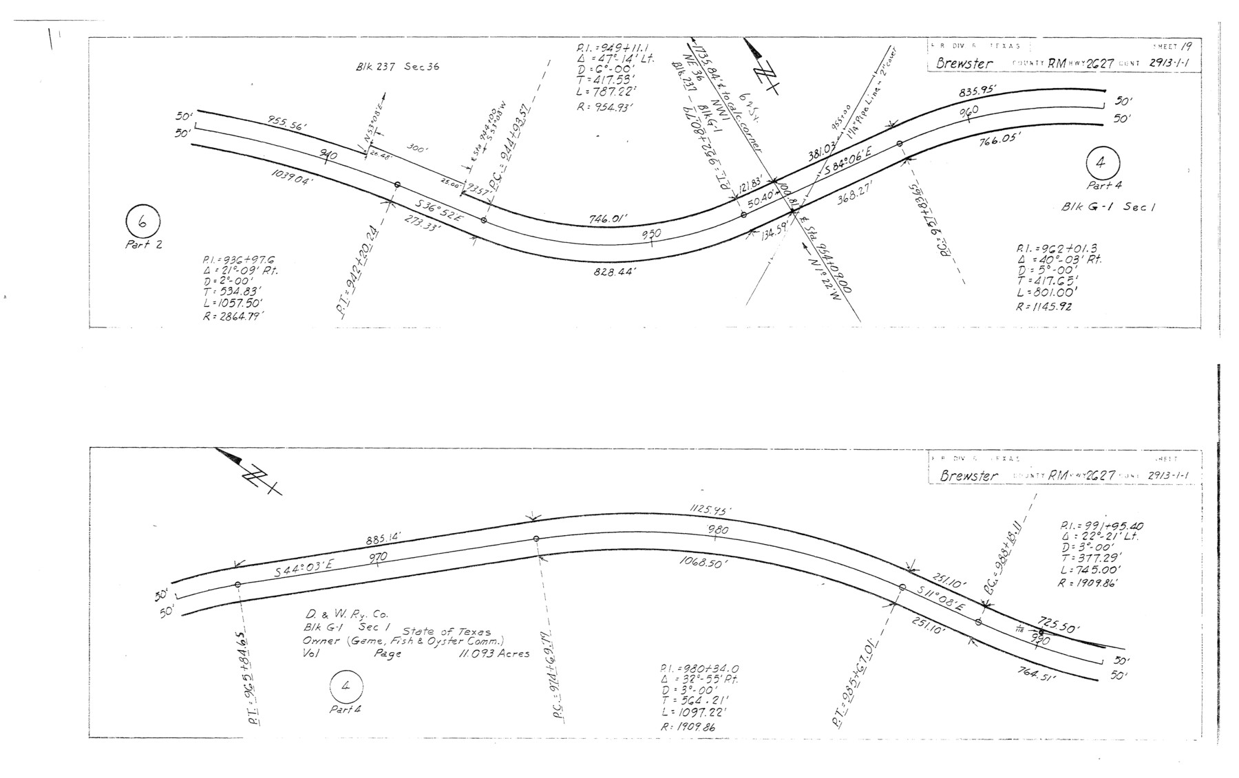
Brewster County Rolled Sketch 114
Plans of proposed State Highway Right of Way, RM Highway 2627, Brewster County, Control 2913-1-1 from: US 383, 38 mi. S of Marathon, SE to: Heath Crossing on Rio Grande (Sheet 19)
-
Map/Doc
5282
-
Collection
General Map Collection
-
Object Dates
1965/3/29 (File Date)
1964/12/3 (Creation Date)
-
People and Organizations
State Highway Department (Publisher)
-
Counties
Brewster
-
Subjects
Surveying Rolled Sketch
-
Height x Width
11.4 x 18.2 inches
29.0 x 46.2 cm
-
Medium
blueprint/diazo
-
Comments
This is one sheet of a set of 29 maps. For the complete set, see map numbers 5264-5292.
Related maps
Brewster County Rolled Sketch 114

Print $20.00
- Digital $50.00
Brewster County Rolled Sketch 114
1964
Size 11.8 x 18.5 inches
Map/Doc 5264
Brewster County Rolled Sketch 114

Print $20.00
- Digital $50.00
Brewster County Rolled Sketch 114
1964
Size 11.7 x 18.4 inches
Map/Doc 5265
Brewster County Rolled Sketch 114

Print $20.00
- Digital $50.00
Brewster County Rolled Sketch 114
1964
Size 11.7 x 18.6 inches
Map/Doc 5266
Brewster County Rolled Sketch 114

Print $20.00
- Digital $50.00
Brewster County Rolled Sketch 114
1964
Size 11.7 x 18.4 inches
Map/Doc 5267
Brewster County Rolled Sketch 114

Print $20.00
- Digital $50.00
Brewster County Rolled Sketch 114
1964
Size 23.8 x 18.9 inches
Map/Doc 5268
Brewster County Rolled Sketch 114

Print $20.00
- Digital $50.00
Brewster County Rolled Sketch 114
1964
Size 11.0 x 18.3 inches
Map/Doc 5269
Brewster County Rolled Sketch 114

Print $20.00
- Digital $50.00
Brewster County Rolled Sketch 114
1964
Size 11.1 x 18.4 inches
Map/Doc 5270
Brewster County Rolled Sketch 114

Print $20.00
- Digital $50.00
Brewster County Rolled Sketch 114
1964
Size 11.5 x 18.5 inches
Map/Doc 5271
Brewster County Rolled Sketch 114

Print $20.00
- Digital $50.00
Brewster County Rolled Sketch 114
1964
Size 11.6 x 18.3 inches
Map/Doc 5272
Brewster County Rolled Sketch 114

Print $20.00
- Digital $50.00
Brewster County Rolled Sketch 114
1964
Size 11.6 x 17.3 inches
Map/Doc 5273
Brewster County Rolled Sketch 114

Print $20.00
- Digital $50.00
Brewster County Rolled Sketch 114
1964
Size 11.5 x 17.6 inches
Map/Doc 5274
Brewster County Rolled Sketch 114

Print $20.00
- Digital $50.00
Brewster County Rolled Sketch 114
1964
Size 11.6 x 18.5 inches
Map/Doc 5275
Brewster County Rolled Sketch 114

Print $20.00
- Digital $50.00
Brewster County Rolled Sketch 114
1964
Size 11.7 x 18.3 inches
Map/Doc 5276
Brewster County Rolled Sketch 114

Print $20.00
- Digital $50.00
Brewster County Rolled Sketch 114
1964
Size 11.4 x 18.4 inches
Map/Doc 5277
Brewster County Rolled Sketch 114

Print $20.00
- Digital $50.00
Brewster County Rolled Sketch 114
1964
Size 12.0 x 18.4 inches
Map/Doc 5278
Brewster County Rolled Sketch 114

Print $20.00
- Digital $50.00
Brewster County Rolled Sketch 114
1964
Size 11.9 x 18.4 inches
Map/Doc 5279
Brewster County Rolled Sketch 114

Print $20.00
- Digital $50.00
Brewster County Rolled Sketch 114
1964
Size 11.9 x 18.3 inches
Map/Doc 5280
Brewster County Rolled Sketch 114

Print $20.00
- Digital $50.00
Brewster County Rolled Sketch 114
1964
Size 11.7 x 17.7 inches
Map/Doc 5281
Brewster County Rolled Sketch 114

Print $20.00
- Digital $50.00
Brewster County Rolled Sketch 114
1964
Size 12.2 x 17.5 inches
Map/Doc 5283
Brewster County Rolled Sketch 114

Print $20.00
- Digital $50.00
Brewster County Rolled Sketch 114
1964
Size 11.4 x 17.7 inches
Map/Doc 5284
Part of: General Map Collection
Archer County Sketch File 14

Print $40.00
- Digital $50.00
Archer County Sketch File 14
1884
Size 19.6 x 23.5 inches
Map/Doc 10826
Red River County Working Sketch 47

Print $20.00
- Digital $50.00
Red River County Working Sketch 47
1969
Size 34.3 x 24.2 inches
Map/Doc 72030
Gillespie County Sketch File 9

Print $4.00
- Digital $50.00
Gillespie County Sketch File 9
1873
Size 8.2 x 10.5 inches
Map/Doc 24145
Culberson County Working Sketch 67

Print $40.00
- Digital $50.00
Culberson County Working Sketch 67
1975
Size 48.9 x 33.2 inches
Map/Doc 68521
Pecos County Sketch File 75

Print $6.00
- Digital $50.00
Pecos County Sketch File 75
1943
Size 11.3 x 8.9 inches
Map/Doc 33904
Crosby County Sketch File 1

Print $4.00
- Digital $50.00
Crosby County Sketch File 1
Size 12.8 x 8.1 inches
Map/Doc 19985
Kaufman County Working Sketch 8

Print $20.00
- Digital $50.00
Kaufman County Working Sketch 8
1987
Size 35.7 x 42.3 inches
Map/Doc 66671
Reagan County Working Sketch 9

Print $20.00
- Digital $50.00
Reagan County Working Sketch 9
1939
Size 12.4 x 24.2 inches
Map/Doc 71849
Greer County Sketch File 1

Print $20.00
- Digital $50.00
Greer County Sketch File 1
Size 27.8 x 19.7 inches
Map/Doc 11581
Johnson County Sketch File 8

Print $6.00
- Digital $50.00
Johnson County Sketch File 8
1859
Size 8.0 x 9.7 inches
Map/Doc 28440
Right-of-Way & Track Map, Houston and Brazos Valley Ry. Co. operated by the Houston and Brazos Valley Ry. Co.

Print $40.00
- Digital $50.00
Right-of-Way & Track Map, Houston and Brazos Valley Ry. Co. operated by the Houston and Brazos Valley Ry. Co.
1918
Size 24.7 x 56.7 inches
Map/Doc 64604
Map of Jack County

Print $20.00
- Digital $50.00
Map of Jack County
1896
Size 20.3 x 17.7 inches
Map/Doc 3699
You may also like
Wichita County Sketch File 12

Print $6.00
- Digital $50.00
Wichita County Sketch File 12
1881
Size 10.2 x 8.3 inches
Map/Doc 40074
Houston County Sketch File 19

Print $4.00
- Digital $50.00
Houston County Sketch File 19
1851
Size 12.8 x 8.3 inches
Map/Doc 26785
Nolan County Sketch File 3

Print $20.00
- Digital $50.00
Nolan County Sketch File 3
Size 8.0 x 36.6 inches
Map/Doc 42161
Duval County Working Sketch 53

Print $20.00
- Digital $50.00
Duval County Working Sketch 53
1948
Size 34.7 x 37.5 inches
Map/Doc 68777
Starr County Sketch File 19

Print $20.00
- Digital $50.00
Starr County Sketch File 19
1887
Size 22.6 x 22.0 inches
Map/Doc 12330
Flight Mission No. CRC-5R, Frame 32, Chambers County

Print $20.00
- Digital $50.00
Flight Mission No. CRC-5R, Frame 32, Chambers County
1956
Size 18.5 x 22.4 inches
Map/Doc 84951

Eastland County Working Sketch 62

Print $20.00
- Digital $50.00
Eastland County Working Sketch 62
1989
Size 20.7 x 28.0 inches
Map/Doc 68843
Dallas County Sketch File 7

Print $4.00
- Digital $50.00
Dallas County Sketch File 7
1858
Size 10.4 x 8.5 inches
Map/Doc 20408
Live Oak County Sketch File 28

Print $10.00
- Digital $50.00
Live Oak County Sketch File 28
1922
Size 14.3 x 8.5 inches
Map/Doc 30314
Survey of a Portion of Lot. No. 1 of Spear League

Print $20.00
- Digital $50.00
Survey of a Portion of Lot. No. 1 of Spear League
1911
Size 12.2 x 24.2 inches
Map/Doc 477
Dimmit County Sketch File 25

Print $4.00
- Digital $50.00
Dimmit County Sketch File 25
1885
Size 12.9 x 8.6 inches
Map/Doc 21142