Mills County Rolled Sketch 6
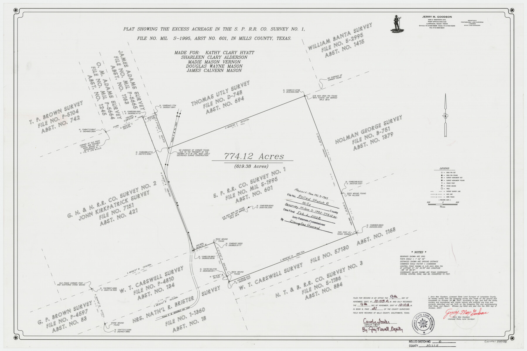
Plat showing the excess acreage in the S. P. R.R. Co. survey no. 1, file no. MIL S-1995, abst. no. 601, in Mills County, Texas
-
Map/Doc
88738
-
Collection
General Map Collection
-
Object Dates
2007/10/29 (Survey Date)
2007/10/30 (Creation Date)
2008/2/1 (File Date)
-
People and Organizations
Jerry Max Goodson (Surveyor/Engineer)
-
Counties
Mills
-
Subjects
Surveying Rolled Sketch
-
Height x Width
24.4 x 36.6 inches
62.0 x 93.0 cm
-
Medium
mylar, print
-
Comments
See MIL S-1995 for report.
Part of: General Map Collection
Terrell County Sketch File 42

Print $20.00
- Digital $50.00
Terrell County Sketch File 42
1885
Map/Doc 97199
Motley County Boundary File 2d

Print $22.00
- Digital $50.00
Motley County Boundary File 2d
Size 14.3 x 8.7 inches
Map/Doc 57550
[Surveys in Austin's Colony along the Brazos River and Oyster Creek]
![206, [Surveys in Austin's Colony along the Brazos River and Oyster Creek], General Map Collection](https://historictexasmaps.com/wmedia_w700/maps/206.tif.jpg)
Print $20.00
- Digital $50.00
[Surveys in Austin's Colony along the Brazos River and Oyster Creek]
1824
Size 23.1 x 17.2 inches
Map/Doc 206
Montgomery County Working Sketch 24

Print $40.00
- Digital $50.00
Montgomery County Working Sketch 24
1941
Size 35.8 x 52.5 inches
Map/Doc 71131
Karnes County Working Sketch 3

Print $20.00
- Digital $50.00
Karnes County Working Sketch 3
1943
Size 34.6 x 31.4 inches
Map/Doc 66651
Lubbock County Boundary File 1

Print $64.00
- Digital $50.00
Lubbock County Boundary File 1
Size 8.8 x 8.6 inches
Map/Doc 56455
Flight Mission No. DQN-1K, Frame 139, Calhoun County

Print $20.00
- Digital $50.00
Flight Mission No. DQN-1K, Frame 139, Calhoun County
1953
Size 18.4 x 22.3 inches
Map/Doc 84202
No. 3 Chart of Channel connecting Corpus Christi Bay with Aransas Bay, Texas

Print $20.00
- Digital $50.00
No. 3 Chart of Channel connecting Corpus Christi Bay with Aransas Bay, Texas
1878
Size 18.3 x 27.9 inches
Map/Doc 72779
Fayette County Working Sketch 1

Print $20.00
- Digital $50.00
Fayette County Working Sketch 1
1949
Size 25.4 x 18.0 inches
Map/Doc 69165
Flight Mission No. CZW-3R, Frame 82

Print $20.00
- Digital $50.00
Flight Mission No. CZW-3R, Frame 82
1956
Size 18.6 x 22.3 inches
Map/Doc 85240
Brazoria County Working Sketch 45

Print $20.00
- Digital $50.00
Brazoria County Working Sketch 45
1988
Size 23.0 x 19.2 inches
Map/Doc 67530
Pecos County Sketch File 19

Print $4.00
- Digital $50.00
Pecos County Sketch File 19
Size 14.2 x 8.8 inches
Map/Doc 33668
You may also like
Burma, Thailand, Indochina and Malayan Federation

Print $3.00
- Digital $50.00
Burma, Thailand, Indochina and Malayan Federation
Size 10.7 x 14.6 inches
Map/Doc 92375
Stephens County Sketch File 9a

Print $4.00
- Digital $50.00
Stephens County Sketch File 9a
1884
Size 8.6 x 8.2 inches
Map/Doc 37040
Pecos County Sketch

Print $20.00
- Digital $50.00
Pecos County Sketch
Size 34.2 x 23.2 inches
Map/Doc 92915
Sherman County Rolled Sketch 5

Print $20.00
- Digital $50.00
Sherman County Rolled Sketch 5
1919
Size 36.9 x 41.4 inches
Map/Doc 9928
Flight Mission No. BRA-6M, Frame 76, Jefferson County

Print $20.00
- Digital $50.00
Flight Mission No. BRA-6M, Frame 76, Jefferson County
1953
Size 18.6 x 22.4 inches
Map/Doc 85420
Palo Pinto County Rolled Sketch 14

Print $20.00
- Digital $50.00
Palo Pinto County Rolled Sketch 14
Size 29.7 x 42.5 inches
Map/Doc 7194
Calhoun County Working Sketch 5

Print $40.00
- Digital $50.00
Calhoun County Working Sketch 5
1941
Size 23.7 x 125.2 inches
Map/Doc 67821
Robertson County Sketch File 9

Print $68.00
Robertson County Sketch File 9
1846
Size 10.2 x 8.3 inches
Map/Doc 35366
Edwards County Working Sketch 47

Print $20.00
- Digital $50.00
Edwards County Working Sketch 47
1950
Size 37.9 x 24.1 inches
Map/Doc 68923
Henderson County Sketch File 22

Print $14.00
- Digital $50.00
Henderson County Sketch File 22
1942
Size 14.2 x 8.9 inches
Map/Doc 26365
Coke County Working Sketch 8

Print $20.00
- Digital $50.00
Coke County Working Sketch 8
1926
Size 26.9 x 25.5 inches
Map/Doc 68045
Flight Mission No. DQO-11K, Frame 25, Galveston County

Print $20.00
- Digital $50.00
Flight Mission No. DQO-11K, Frame 25, Galveston County
1952
Size 18.8 x 22.4 inches
Map/Doc 85222