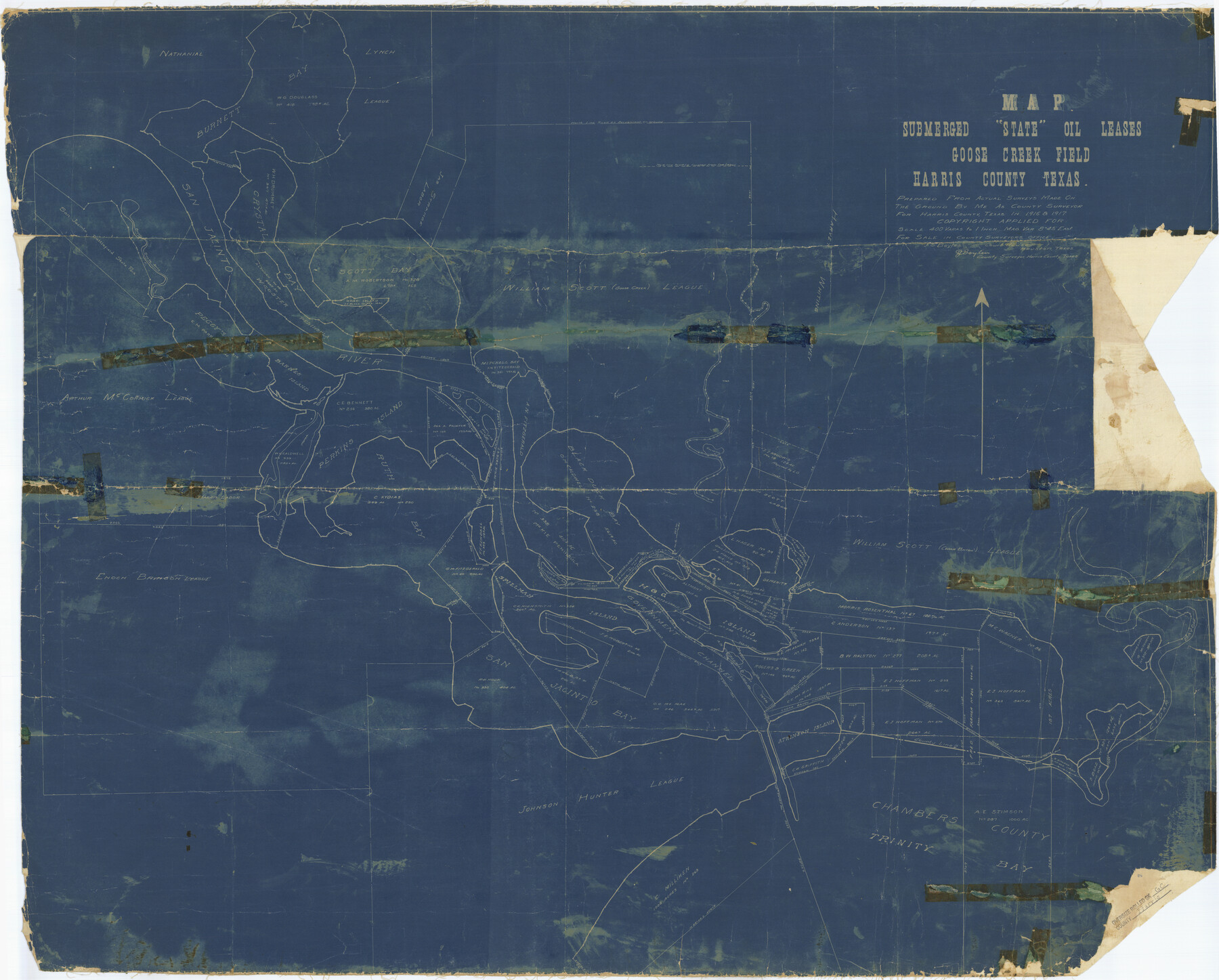
Harris County Rolled Sketch GC
Map submerged "State" oil leases, Goose Creek Field, Harris County, Texas
-
Map/Doc
9115
-
Collection
General Map Collection
-
Object Dates
1917/6/5 (File Date)
1917 (Creation Date)
-
People and Organizations
J.S. Boyles (Surveyor/Engineer)
-
Counties
Harris
-
Subjects
Surveying Rolled Sketch
-
Height x Width
42.1 x 52.4 inches
106.9 x 133.1 cm
-
Medium
blueprint/diazo
-
Scale
1" = 400 varas
Part of: General Map Collection
Karnes County Boundary File 5b

Print $78.00
- Digital $50.00
Karnes County Boundary File 5b
Size 7.4 x 6.1 inches
Map/Doc 55723
Brewster County Sketch File N-3c

Print $4.00
- Digital $50.00
Brewster County Sketch File N-3c
Size 12.7 x 8.4 inches
Map/Doc 15594
Map of Wharton County

Print $20.00
- Digital $50.00
Map of Wharton County
1865
Size 24.9 x 26.9 inches
Map/Doc 4136
Hardin County Rolled Sketch 15

Print $20.00
- Digital $50.00
Hardin County Rolled Sketch 15
1938
Size 30.9 x 23.7 inches
Map/Doc 6084
Nueces County Sketch File 35

Print $2.00
- Digital $50.00
Nueces County Sketch File 35
1913
Size 13.1 x 4.8 inches
Map/Doc 32613
Cooke County Sketch File 7

Print $8.00
- Digital $50.00
Cooke County Sketch File 7
1855
Size 10.8 x 8.3 inches
Map/Doc 19231
Nueces County Rolled Sketch 107

Print $56.00
Nueces County Rolled Sketch 107
1987
Size 18.4 x 24.8 inches
Map/Doc 7104
Mexico und Texas

Print $20.00
- Digital $50.00
Mexico und Texas
1851
Size 15.8 x 19.1 inches
Map/Doc 93714
Baie de Galvez-Town

Print $20.00
- Digital $50.00
Baie de Galvez-Town
Size 10.3 x 12.9 inches
Map/Doc 95832
[Map of the Stockdale-Cuero Extension G.H. & S.A. Ry.]
![64095, [Map of the Stockdale-Cuero Extension G.H. & S.A. Ry.], General Map Collection](https://historictexasmaps.com/wmedia_w700/maps/64095.tif.jpg)
Print $40.00
- Digital $50.00
[Map of the Stockdale-Cuero Extension G.H. & S.A. Ry.]
1905
Size 19.6 x 128.0 inches
Map/Doc 64095
Medina County

Print $40.00
- Digital $50.00
Medina County
1915
Size 50.0 x 42.0 inches
Map/Doc 66925
Jones County Sketch File 5a

Print $20.00
- Digital $50.00
Jones County Sketch File 5a
1857
Size 18.4 x 23.5 inches
Map/Doc 11896
You may also like
Guadalupe County Sketch File 20

Print $6.00
- Digital $50.00
Guadalupe County Sketch File 20
1912
Size 11.1 x 8.7 inches
Map/Doc 24699
Anderson County

Print $20.00
- Digital $50.00
Anderson County
1861
Size 18.0 x 21.2 inches
Map/Doc 774
Travis County Appraisal District Plat Map 2_0018

Print $20.00
- Digital $50.00
Travis County Appraisal District Plat Map 2_0018
Size 21.6 x 26.5 inches
Map/Doc 94208
[Midland County School Land, Martin County School Land, and vicinity]
![91128, [Midland County School Land, Martin County School Land, and vicinity], Twichell Survey Records](https://historictexasmaps.com/wmedia_w700/maps/91128-1.tif.jpg)
Print $2.00
- Digital $50.00
[Midland County School Land, Martin County School Land, and vicinity]
Size 9.0 x 11.4 inches
Map/Doc 91128
Dawson County Sketch File 27

Print $8.00
- Digital $50.00
Dawson County Sketch File 27
Size 12.6 x 8.5 inches
Map/Doc 20588
North Line of Stonewall County, South Line of King County

Print $20.00
- Digital $50.00
North Line of Stonewall County, South Line of King County
1895
Size 8.0 x 41.1 inches
Map/Doc 91058
Presidio County Rolled Sketch 87

Print $20.00
- Digital $50.00
Presidio County Rolled Sketch 87
Size 26.4 x 38.2 inches
Map/Doc 7373
Crockett County Rolled Sketch 79

Print $40.00
- Digital $50.00
Crockett County Rolled Sketch 79
1954
Size 37.3 x 48.3 inches
Map/Doc 8724
Hunt County Sketch File 4

Print $4.00
- Digital $50.00
Hunt County Sketch File 4
1852
Size 12.1 x 7.7 inches
Map/Doc 27087
J. De Cordova's Map of the State of Texas Compiled from the records of the General Land Office of the State

Print $20.00
- Digital $50.00
J. De Cordova's Map of the State of Texas Compiled from the records of the General Land Office of the State
1867
Size 38.0 x 35.4 inches
Map/Doc 93759
Flight Mission No. BRA-16M, Frame 96, Jefferson County

Print $20.00
- Digital $50.00
Flight Mission No. BRA-16M, Frame 96, Jefferson County
1953
Size 18.6 x 22.4 inches
Map/Doc 85708
General Highway Map, Franklin County, Morris County, Titus County, Camp County

Print $20.00
General Highway Map, Franklin County, Morris County, Titus County, Camp County
1940
Size 18.4 x 25.1 inches
Map/Doc 79040