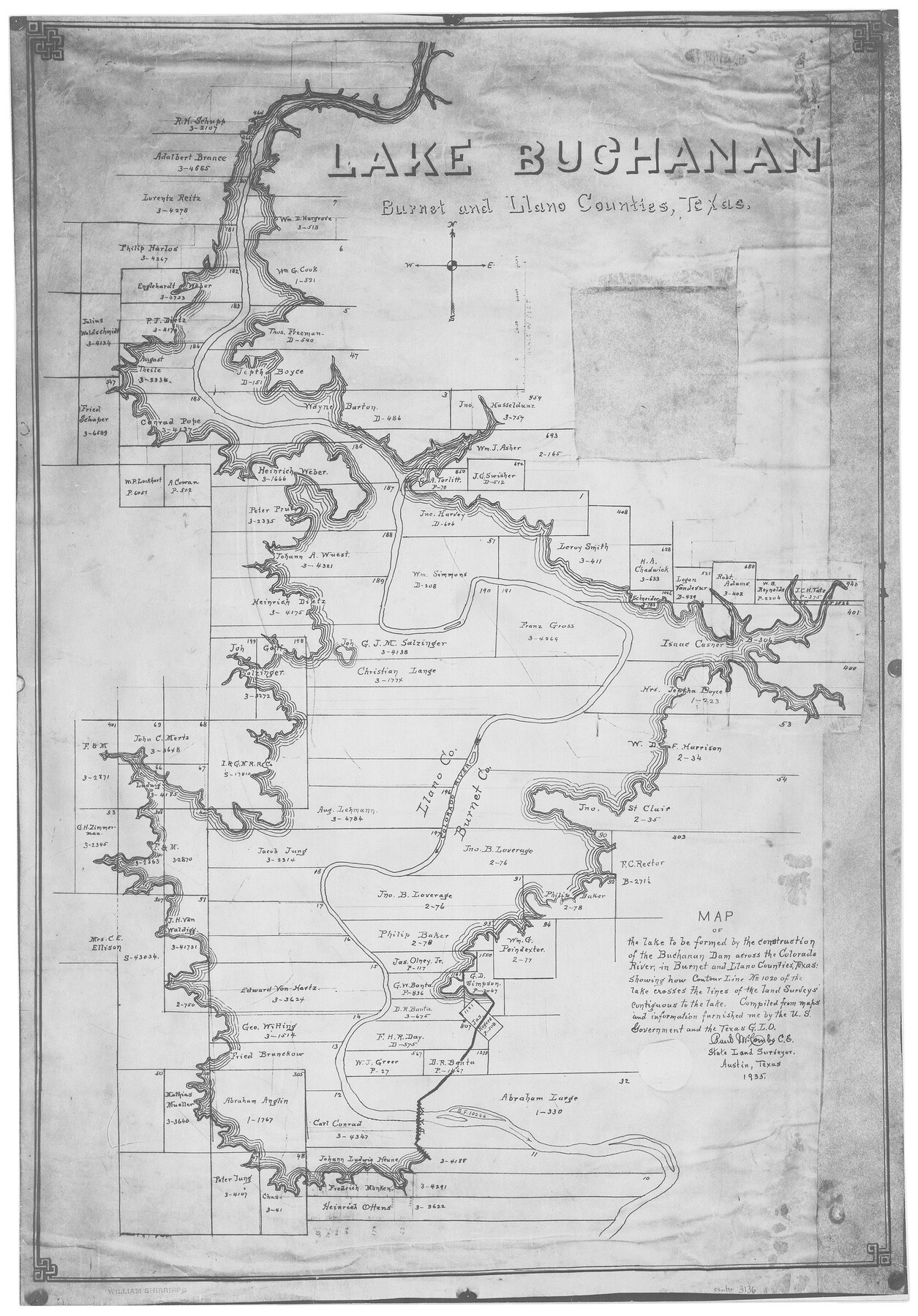
Lake Buchanan, Burnet and Llano Counties, Texas
N-2-110
-
Map/Doc
3136
-
Collection
General Map Collection
-
Object Dates
1935 (Creation Date)
-
People and Organizations
Paul McCombs (Surveyor/Engineer)
-
Counties
Burnet Llano
-
Subjects
River Surveys
-
Height x Width
20.7 x 14.4 inches
52.6 x 36.6 cm
Part of: General Map Collection
Cherokee County Sketch File 20

Print $4.00
- Digital $50.00
Cherokee County Sketch File 20
1876
Size 8.2 x 6.0 inches
Map/Doc 18163
Lampasas County Working Sketch 10

Print $20.00
- Digital $50.00
Lampasas County Working Sketch 10
1963
Size 32.2 x 42.9 inches
Map/Doc 70287
Collingsworth County Working Sketch 2

Print $40.00
- Digital $50.00
Collingsworth County Working Sketch 2
1957
Size 44.2 x 122.7 inches
Map/Doc 68090
Jasper County Working Sketch 18

Print $20.00
- Digital $50.00
Jasper County Working Sketch 18
1934
Size 22.4 x 30.5 inches
Map/Doc 66480
Travis County Sketch File 52

Print $8.00
- Digital $50.00
Travis County Sketch File 52
1942
Size 14.4 x 8.9 inches
Map/Doc 38391
Brewster County Working Sketch 69

Print $20.00
- Digital $50.00
Brewster County Working Sketch 69
1961
Size 24.5 x 27.5 inches
Map/Doc 67670
Flight Mission No. CLL-3N, Frame 42, Willacy County

Print $20.00
- Digital $50.00
Flight Mission No. CLL-3N, Frame 42, Willacy County
1954
Size 18.5 x 22.1 inches
Map/Doc 87100
Lynn County Boundary File 7b

Print $8.00
- Digital $50.00
Lynn County Boundary File 7b
Size 11.3 x 8.6 inches
Map/Doc 56651
Upton County Working Sketch 29

Print $40.00
- Digital $50.00
Upton County Working Sketch 29
1956
Size 50.6 x 36.0 inches
Map/Doc 69525
Val Verde County Sketch File 51

Print $10.00
- Digital $50.00
Val Verde County Sketch File 51
1959
Size 9.8 x 8.7 inches
Map/Doc 39320
Harbor Pass and Bar at Brazos Santiago, Texas

Print $20.00
- Digital $50.00
Harbor Pass and Bar at Brazos Santiago, Texas
1871
Size 26.8 x 18.3 inches
Map/Doc 72984
Matagorda County Sketch File 24

Print $10.00
- Digital $50.00
Matagorda County Sketch File 24
1900
Size 8.2 x 5.1 inches
Map/Doc 30787
You may also like
Texas Oil and Gas Fields and Truck Pipe Line Systems

Print $20.00
Texas Oil and Gas Fields and Truck Pipe Line Systems
1926
Size 21.7 x 30.8 inches
Map/Doc 79327
Dimmit County

Print $40.00
- Digital $50.00
Dimmit County
1976
Size 43.2 x 50.7 inches
Map/Doc 73133
Terry County Sketch File 20

Print $4.00
- Digital $50.00
Terry County Sketch File 20
2001
Size 11.1 x 8.8 inches
Map/Doc 76365
Map of SW portion of Hale Co., Texas

Print $3.00
- Digital $50.00
Map of SW portion of Hale Co., Texas
Size 12.7 x 10.8 inches
Map/Doc 518
Donley County Sketch File B5

Print $20.00
- Digital $50.00
Donley County Sketch File B5
1918
Size 22.5 x 18.4 inches
Map/Doc 11375
[John P. Rohus and surrounding surveys]
![90974, [John P. Rohus and surrounding surveys], Twichell Survey Records](https://historictexasmaps.com/wmedia_w700/maps/90974-1.tif.jpg)
Print $20.00
- Digital $50.00
[John P. Rohus and surrounding surveys]
Size 26.1 x 19.9 inches
Map/Doc 90974
Presidio County Rolled Sketch 93

Print $20.00
- Digital $50.00
Presidio County Rolled Sketch 93
Size 35.5 x 31.1 inches
Map/Doc 7378
Hall County Rolled Sketch 7

Print $20.00
- Digital $50.00
Hall County Rolled Sketch 7
Size 9.2 x 26.4 inches
Map/Doc 6051
Polk County Sketch File 35

Print $8.00
- Digital $50.00
Polk County Sketch File 35
1891
Size 14.2 x 8.7 inches
Map/Doc 34232
Runnels County Working Sketch 11
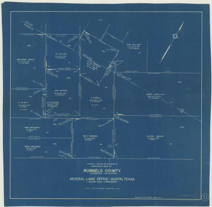
Print $20.00
- Digital $50.00
Runnels County Working Sketch 11
1949
Size 24.6 x 25.2 inches
Map/Doc 63607
Gulf of Mexico

Print $20.00
- Digital $50.00
Gulf of Mexico
1908
Size 18.4 x 27.9 inches
Map/Doc 72662
Zavala County Working Sketch 24

Print $40.00
- Digital $50.00
Zavala County Working Sketch 24
1980
Size 75.6 x 42.8 inches
Map/Doc 62099