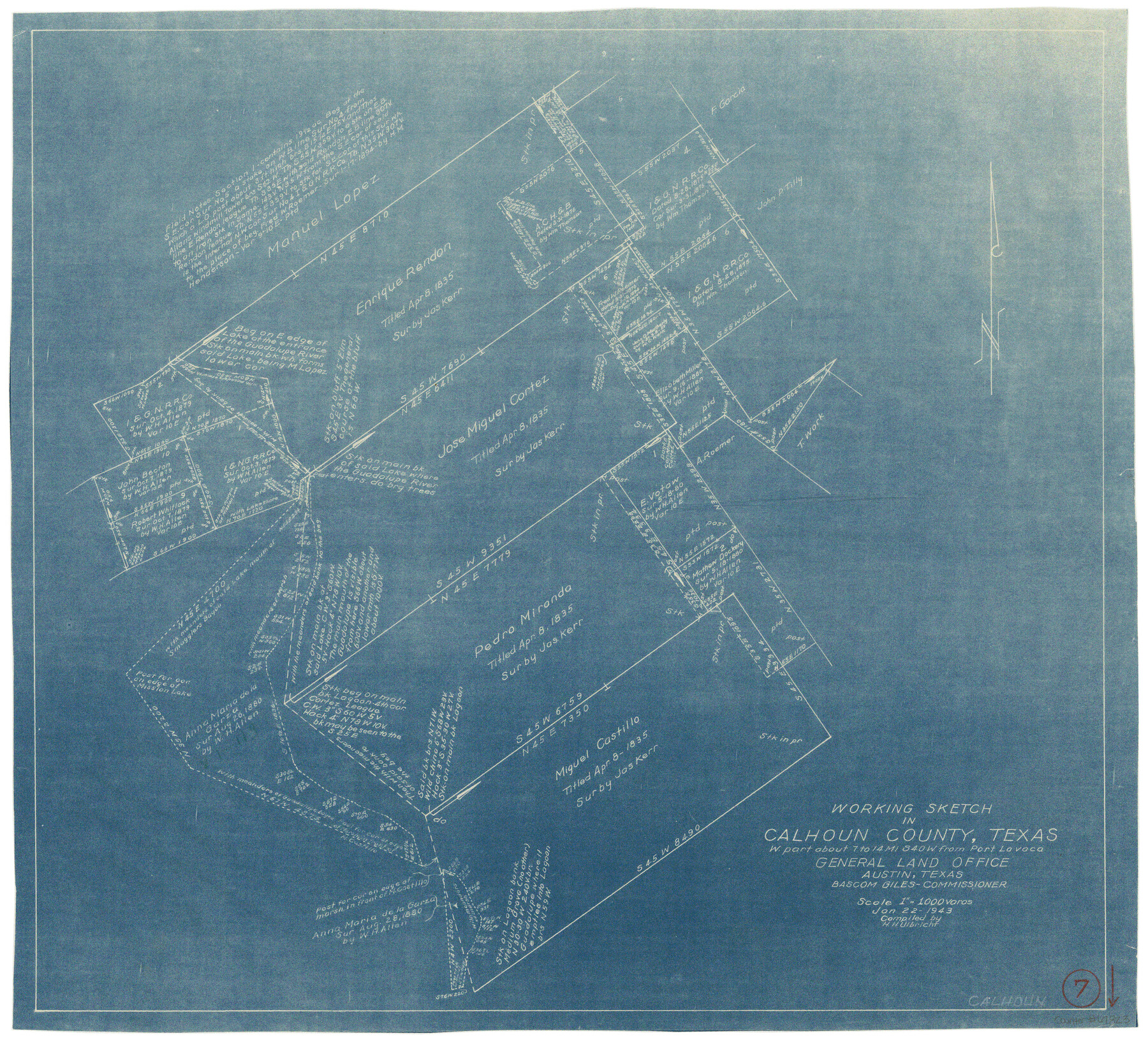
Calhoun County Working Sketch 7
-
Map/Doc
67823
-
Collection
General Map Collection
-
Object Dates
1/22/1943 (Creation Date)
-
People and Organizations
Herbert H. Ulbricht (Compiler)
-
Counties
Calhoun
-
Subjects
Surveying Working Sketch
-
Height x Width
20.1 x 22.0 inches
51.1 x 55.9 cm
-
Scale
1" = 1000 varas
Part of: General Map Collection
Map of the Central States to illustrate Olney's school geography

Print $20.00
- Digital $50.00
Map of the Central States to illustrate Olney's school geography
1844
Size 12.1 x 19.0 inches
Map/Doc 93539
Val Verde County Rolled Sketch 81

Print $20.00
- Digital $50.00
Val Verde County Rolled Sketch 81
Size 35.0 x 44.7 inches
Map/Doc 10088
Aransas County Rolled Sketch 15C

Print $3.00
- Digital $50.00
Aransas County Rolled Sketch 15C
Size 10.2 x 17.6 inches
Map/Doc 76067
Kimble County Rolled Sketch 20

Print $20.00
- Digital $50.00
Kimble County Rolled Sketch 20
Size 14.6 x 18.1 inches
Map/Doc 6511
Flight Mission No. BRA-7M, Frame 86, Jefferson County

Print $20.00
- Digital $50.00
Flight Mission No. BRA-7M, Frame 86, Jefferson County
1953
Size 18.7 x 22.4 inches
Map/Doc 85508
Hale County Boundary File 9

Print $68.00
- Digital $50.00
Hale County Boundary File 9
Size 14.2 x 8.8 inches
Map/Doc 54111
Dimmit County Working Sketch 3

Print $20.00
- Digital $50.00
Dimmit County Working Sketch 3
1911
Size 16.5 x 22.5 inches
Map/Doc 68664
Flight Mission No. DQN-5K, Frame 49, Calhoun County

Print $20.00
- Digital $50.00
Flight Mission No. DQN-5K, Frame 49, Calhoun County
1953
Size 17.4 x 22.3 inches
Map/Doc 84394
Castro County Sketch File 18

Print $20.00
- Digital $50.00
Castro County Sketch File 18
1988
Size 40.4 x 37.7 inches
Map/Doc 10330
Harbor of Brazos Santiago, Texas

Print $20.00
- Digital $50.00
Harbor of Brazos Santiago, Texas
1887
Size 27.1 x 18.3 inches
Map/Doc 72998
Flight Mission No. DCL-7C, Frame 73, Kenedy County

Print $20.00
- Digital $50.00
Flight Mission No. DCL-7C, Frame 73, Kenedy County
1943
Size 15.6 x 15.3 inches
Map/Doc 86059
Prison Property, Walker Co.

Print $20.00
- Digital $50.00
Prison Property, Walker Co.
Size 24.4 x 23.5 inches
Map/Doc 62976
You may also like
Nueces County Rolled Sketch 79

Print $20.00
- Digital $50.00
Nueces County Rolled Sketch 79
1894
Size 38.1 x 31.3 inches
Map/Doc 9627
Geological map of the State of Pennsylvania constructed from original surveys

Print $40.00
- Digital $50.00
Geological map of the State of Pennsylvania constructed from original surveys
1858
Size 39.3 x 71.6 inches
Map/Doc 93772
The Republic County of San Patricio. Proposed, Late Fall 1837-December 31, 1838

Print $20.00
The Republic County of San Patricio. Proposed, Late Fall 1837-December 31, 1838
2020
Size 22.2 x 21.7 inches
Map/Doc 96274
Texas 1973 Official Highway Travel Map

Texas 1973 Official Highway Travel Map
Size 28.2 x 36.3 inches
Map/Doc 94405
Travis County Working Sketch 52

Print $20.00
- Digital $50.00
Travis County Working Sketch 52
1985
Size 28.2 x 10.0 inches
Map/Doc 69436
Bosque County Sketch File 30b

Print $8.00
- Digital $50.00
Bosque County Sketch File 30b
1854
Size 12.7 x 8.1 inches
Map/Doc 14826
Childress County Rolled Sketch 9

Print $20.00
- Digital $50.00
Childress County Rolled Sketch 9
Size 19.3 x 22.9 inches
Map/Doc 5446
Flight Mission No. CON-2R, Frame 116, Stonewall County

Print $20.00
- Digital $50.00
Flight Mission No. CON-2R, Frame 116, Stonewall County
1957
Size 18.3 x 22.2 inches
Map/Doc 86990
Hansford County, Texas

Print $20.00
- Digital $50.00
Hansford County, Texas
1888
Size 22.6 x 18.6 inches
Map/Doc 5033
Flight Mission No. DCL-6C, Frame 121, Kenedy County

Print $20.00
- Digital $50.00
Flight Mission No. DCL-6C, Frame 121, Kenedy County
1943
Size 18.6 x 22.4 inches
Map/Doc 85951
Medina County Working Sketch 26

Print $20.00
- Digital $50.00
Medina County Working Sketch 26
1985
Size 30.6 x 30.5 inches
Map/Doc 70941
Hall County Sketch File 4

Print $6.00
- Digital $50.00
Hall County Sketch File 4
Size 14.2 x 9.3 inches
Map/Doc 24800