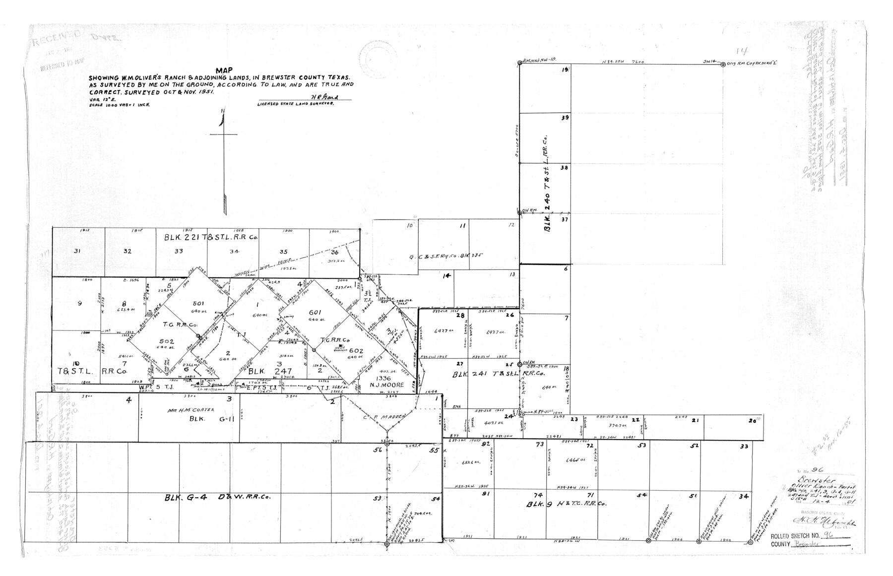
Brewster County Rolled Sketch 96
Map showing W.M. Oliver's Ranch & adjoining lands, in Brewster County, Texas
-
Map/Doc
5253
-
Collection
General Map Collection
-
Object Dates
1951 (Creation Date)
1951/12/4 (File Date)
-
People and Organizations
H.R. Gard (Surveyor/Engineer)
-
Counties
Brewster
-
Subjects
Surveying Rolled Sketch
-
Height x Width
21.7 x 33.7 inches
55.1 x 85.6 cm
-
Scale
1" = 1000 varas
Part of: General Map Collection
Wood County Working Sketch 23

Print $40.00
- Digital $50.00
Wood County Working Sketch 23
1962
Size 54.9 x 43.5 inches
Map/Doc 78230
Flight Mission No. DAG-21K, Frame 130, Matagorda County

Print $20.00
- Digital $50.00
Flight Mission No. DAG-21K, Frame 130, Matagorda County
1952
Size 18.5 x 22.4 inches
Map/Doc 86456
Flight Mission No. DQO-8K, Frame 140, Galveston County

Print $20.00
- Digital $50.00
Flight Mission No. DQO-8K, Frame 140, Galveston County
1952
Size 18.7 x 22.4 inches
Map/Doc 85202
Swisher County

Print $20.00
- Digital $50.00
Swisher County
1910
Size 47.5 x 39.8 inches
Map/Doc 16888
[Surveys in Austin's Colony]
![78, [Surveys in Austin's Colony], General Map Collection](https://historictexasmaps.com/wmedia_w700/maps/78.tif.jpg)
Print $20.00
- Digital $50.00
[Surveys in Austin's Colony]
Size 16.0 x 13.0 inches
Map/Doc 78
Hudspeth County Rolled Sketch 66

Print $20.00
- Digital $50.00
Hudspeth County Rolled Sketch 66
1973
Size 12.1 x 19.9 inches
Map/Doc 6260
Wise County Sketch File 26b

Print $20.00
- Digital $50.00
Wise County Sketch File 26b
1855
Size 13.3 x 19.9 inches
Map/Doc 12700
Hudspeth County Rolled Sketch 13
Print $40.00
- Digital $50.00
Hudspeth County Rolled Sketch 13
1885
Size 22.6 x 62.1 inches
Map/Doc 9201
Jefferson County Sketch File 5b

Print $6.00
- Digital $50.00
Jefferson County Sketch File 5b
1860
Size 9.3 x 11.1 inches
Map/Doc 28108
Waller County Sketch File 1

Print $14.00
- Digital $50.00
Waller County Sketch File 1
Size 8.1 x 6.9 inches
Map/Doc 39563
Wichita County Sketch File 25

Print $20.00
- Digital $50.00
Wichita County Sketch File 25
1919
Size 17.6 x 22.3 inches
Map/Doc 12685
Palo Pinto County Sketch File 22

Print $20.00
- Digital $50.00
Palo Pinto County Sketch File 22
1939
Size 19.6 x 15.0 inches
Map/Doc 12134
You may also like
Borden County Working Sketch 9

Print $20.00
- Digital $50.00
Borden County Working Sketch 9
1951
Size 24.8 x 42.3 inches
Map/Doc 67469
Flight Mission No. CUG-3P, Frame 136, Kleberg County

Print $20.00
- Digital $50.00
Flight Mission No. CUG-3P, Frame 136, Kleberg County
1956
Size 18.5 x 22.3 inches
Map/Doc 86271
Kleberg County Rolled Sketch 10-31

Print $20.00
- Digital $50.00
Kleberg County Rolled Sketch 10-31
1952
Size 37.9 x 40.3 inches
Map/Doc 9398
Blanco County Sketch File 21b

Print $40.00
- Digital $50.00
Blanco County Sketch File 21b
1882
Size 16.9 x 17.8 inches
Map/Doc 10930
General Highway Map, Howard County, Texas

Print $20.00
General Highway Map, Howard County, Texas
1961
Size 18.1 x 24.6 inches
Map/Doc 79526
Flight Mission No. CGI-1N, Frame 183, Cameron County

Print $20.00
- Digital $50.00
Flight Mission No. CGI-1N, Frame 183, Cameron County
1955
Size 18.8 x 22.2 inches
Map/Doc 84518
Texas: Her Resources and Capabilities: being a description of the State of Texas and the inducements She offers to those seeking homes in a new country

Texas: Her Resources and Capabilities: being a description of the State of Texas and the inducements She offers to those seeking homes in a new country
1881
Size 9.3 x 6.1 inches
Map/Doc 96615
Motley County Sketch File 11 (N)

Print $14.00
- Digital $50.00
Motley County Sketch File 11 (N)
1900
Size 11.1 x 8.6 inches
Map/Doc 32036
Flight Mission No. DQN-1K, Frame 27, Calhoun County

Print $20.00
- Digital $50.00
Flight Mission No. DQN-1K, Frame 27, Calhoun County
1953
Size 18.5 x 22.1 inches
Map/Doc 84132
Borden County Rolled Sketch 7

Print $20.00
- Digital $50.00
Borden County Rolled Sketch 7
Size 16.9 x 18.5 inches
Map/Doc 5157
Zapata County Rolled Sketch 14

Print $20.00
- Digital $50.00
Zapata County Rolled Sketch 14
1925
Size 19.2 x 43.7 inches
Map/Doc 10168
Sabine County Sketch File 7a

Print $4.00
Sabine County Sketch File 7a
1882
Size 14.2 x 8.7 inches
Map/Doc 35620