Motley County Sketch File 11 (N)
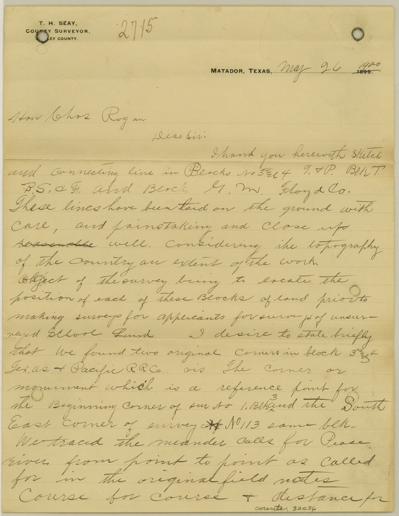
[Connecting line from Blocks 3 and 4, T. & P. extending to Blocks F and G. M.]
-
Map/Doc
32036
-
Collection
General Map Collection
-
Object Dates
5/26/1900 (Creation Date)
5/31/1900 (File Date)
5/26/1900 (Correspondence Date)
-
People and Organizations
T.H. Seay (Surveyor/Engineer)
-
Counties
Motley
-
Subjects
Surveying Sketch File
-
Height x Width
11.1 x 8.6 inches
28.2 x 21.8 cm
-
Medium
paper, manuscript
-
Features
Pease River
Tom Ball Creek
Part of: General Map Collection
[Three Mile Line and Three League Line]
![76120, [Three Mile Line and Three League Line], General Map Collection](https://historictexasmaps.com/wmedia_w700/maps/76120.tif.jpg)
Print $20.00
- Digital $50.00
[Three Mile Line and Three League Line]
1973
Size 43.2 x 33.3 inches
Map/Doc 76120
Harrison County Working Sketch 10

Print $20.00
- Digital $50.00
Harrison County Working Sketch 10
1957
Size 25.8 x 24.6 inches
Map/Doc 66030
Walker County Sketch File 1

Print $4.00
- Digital $50.00
Walker County Sketch File 1
1853
Size 9.7 x 8.3 inches
Map/Doc 39547
San Patricio County Rolled Sketch 46B

Print $3.00
- Digital $50.00
San Patricio County Rolled Sketch 46B
1983
Size 12.5 x 10.0 inches
Map/Doc 8373
Duval County Sketch File 75

Print $20.00
- Digital $50.00
Duval County Sketch File 75
1935
Size 18.0 x 28.5 inches
Map/Doc 11409
Henderson County Sketch File 7

Print $4.00
- Digital $50.00
Henderson County Sketch File 7
1854
Size 8.6 x 8.6 inches
Map/Doc 26329
Brewster County Sketch File NS-2

Print $14.00
- Digital $50.00
Brewster County Sketch File NS-2
1913
Size 14.3 x 8.8 inches
Map/Doc 15946
Map of Erath County

Print $20.00
- Digital $50.00
Map of Erath County
1872
Size 20.2 x 19.8 inches
Map/Doc 3521
Intracoastal Waterway in Texas - Corpus Christi to Point Isabel including Arroyo Colorado to Mo. Pac. R.R. Bridge Near Harlingen

Print $20.00
- Digital $50.00
Intracoastal Waterway in Texas - Corpus Christi to Point Isabel including Arroyo Colorado to Mo. Pac. R.R. Bridge Near Harlingen
1934
Size 21.6 x 32.7 inches
Map/Doc 61879
Baylor County Boundary File 11

Print $26.00
- Digital $50.00
Baylor County Boundary File 11
Size 11.1 x 8.7 inches
Map/Doc 50419
Flight Mission No. DQO-8K, Frame 55, Galveston County

Print $20.00
- Digital $50.00
Flight Mission No. DQO-8K, Frame 55, Galveston County
1952
Size 18.7 x 22.5 inches
Map/Doc 85162
Houston County

Print $40.00
- Digital $50.00
Houston County
1944
Size 52.4 x 52.2 inches
Map/Doc 95534
You may also like
[Map of the Fort Worth & Denver City Railway, Hartley County, Texas]
![64389, [Map of the Fort Worth & Denver City Railway, Hartley County, Texas], General Map Collection](https://historictexasmaps.com/wmedia_w700/maps/64389.tif.jpg)
Print $40.00
- Digital $50.00
[Map of the Fort Worth & Denver City Railway, Hartley County, Texas]
1887
Size 22.0 x 120.7 inches
Map/Doc 64389
Bravo Deed, Instrument 24, Tract A and Tract B

Digital $50.00
Bravo Deed, Instrument 24, Tract A and Tract B
Map/Doc 91480

General Highway Map, Menard County, Texas

Print $20.00
General Highway Map, Menard County, Texas
1961
Size 18.2 x 24.8 inches
Map/Doc 79595
The Chief Justice County of Jasper. April 21, 1837

Print $20.00
The Chief Justice County of Jasper. April 21, 1837
2020
Size 18.3 x 21.7 inches
Map/Doc 96052
[Sketch showing H. T. & B. RR. Co. Sections 125 and 126, B. H. Epperson, Mary Fury, Henry Rogers and Wm. H. Sergeant]
![90882, [Sketch showing H. T. & B. RR. Co. Sections 125 and 126, B. H. Epperson, Mary Fury, Henry Rogers and Wm. H. Sergeant], Twichell Survey Records](https://historictexasmaps.com/wmedia_w700/maps/90882-1.tif.jpg)
Print $20.00
- Digital $50.00
[Sketch showing H. T. & B. RR. Co. Sections 125 and 126, B. H. Epperson, Mary Fury, Henry Rogers and Wm. H. Sergeant]
Size 14.5 x 19.4 inches
Map/Doc 90882
Duval County Sketch File 35b

Print $6.00
- Digital $50.00
Duval County Sketch File 35b
1935
Size 14.4 x 8.8 inches
Map/Doc 21374
Working Sketch Patents & Field Notes, Sabine Lake Area

Print $20.00
- Digital $50.00
Working Sketch Patents & Field Notes, Sabine Lake Area
1959
Size 30.2 x 27.0 inches
Map/Doc 2455

Map of the Reconnaissance in Texas by Lieuts Blake & Meade of the Corps of Topl. Engrs.

Print $20.00
- Digital $50.00
Map of the Reconnaissance in Texas by Lieuts Blake & Meade of the Corps of Topl. Engrs.
1845
Size 27.7 x 18.5 inches
Map/Doc 72892
Flight Mission No. CUG-1P, Frame 114, Kleberg County

Print $20.00
- Digital $50.00
Flight Mission No. CUG-1P, Frame 114, Kleberg County
1956
Size 18.5 x 22.1 inches
Map/Doc 86164
King County Working Sketch 11

Print $40.00
- Digital $50.00
King County Working Sketch 11
1971
Size 49.7 x 25.0 inches
Map/Doc 70175