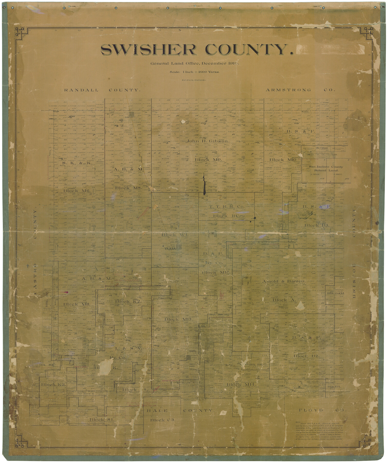
Swisher County
-
Map/Doc
16888
-
Collection
General Map Collection
-
Object Dates
12/1910 (Creation Date)
-
People and Organizations
S.C. Clark (Draftsman)
-
Counties
Swisher
-
Subjects
County
-
Height x Width
47.5 x 39.8 inches
120.7 x 101.1 cm
-
Comments
Help Save Texas History - Adopt Me!
-
Features
Happy
Carters Road
Middle Tule Creek
P&NT
Tule Creek
Tulia
South Tule Creek
Kress
Whitfield
North Tule Creek
Middle Tule Road
Part of: General Map Collection
Flight Mission No. BRA-7M, Frame 84, Jefferson County

Print $20.00
- Digital $50.00
Flight Mission No. BRA-7M, Frame 84, Jefferson County
1953
Size 18.6 x 22.3 inches
Map/Doc 85506
Stonewall County

Print $40.00
- Digital $50.00
Stonewall County
1933
Size 48.0 x 39.4 inches
Map/Doc 95646
Orange County NRC Article 33.136 Location Key Sheet

Print $20.00
- Digital $50.00
Orange County NRC Article 33.136 Location Key Sheet
1974
Size 27.0 x 23.0 inches
Map/Doc 87911
Coryell County Sketch File 24

Print $24.00
- Digital $50.00
Coryell County Sketch File 24
1965
Size 11.2 x 8.8 inches
Map/Doc 19389

Blanco County Working Sketch 45

Print $20.00
- Digital $50.00
Blanco County Working Sketch 45
2007
Size 23.9 x 34.0 inches
Map/Doc 88609
[Beaumont, Sour Lake and Western Ry. Right of Way and Alignment - Frisco]
![64128, [Beaumont, Sour Lake and Western Ry. Right of Way and Alignment - Frisco], General Map Collection](https://historictexasmaps.com/wmedia_w700/maps/64128.tif.jpg)
Print $20.00
- Digital $50.00
[Beaumont, Sour Lake and Western Ry. Right of Way and Alignment - Frisco]
1910
Size 20.1 x 45.9 inches
Map/Doc 64128
Controlled Mosaic by Jack Amman Photogrammetric Engineers, Inc - Sheet 24

Print $20.00
- Digital $50.00
Controlled Mosaic by Jack Amman Photogrammetric Engineers, Inc - Sheet 24
1954
Size 20.0 x 24.0 inches
Map/Doc 83475
Pecos County Rolled Sketch 81

Print $20.00
- Digital $50.00
Pecos County Rolled Sketch 81
1930
Size 35.9 x 25.4 inches
Map/Doc 7240
Aransas County Boundary File 5a

Print $14.00
- Digital $50.00
Aransas County Boundary File 5a
Size 11.3 x 8.7 inches
Map/Doc 49796
Wheeler County Working Sketch 15

Print $20.00
- Digital $50.00
Wheeler County Working Sketch 15
1981
Size 27.9 x 29.3 inches
Map/Doc 72504
Val Verde County Rolled Sketch 78

Print $20.00
- Digital $50.00
Val Verde County Rolled Sketch 78
1981
Size 42.9 x 29.6 inches
Map/Doc 8140
You may also like
Colorado County Working Sketch 5

Print $40.00
- Digital $50.00
Colorado County Working Sketch 5
1919
Size 82.4 x 44.1 inches
Map/Doc 68105
Howard County Rolled Sketch 4

Print $20.00
- Digital $50.00
Howard County Rolled Sketch 4
1909
Size 35.6 x 27.4 inches
Map/Doc 6233
Culberson County Rolled Sketch 48

Print $335.00
- Digital $50.00
Culberson County Rolled Sketch 48
1960
Size 11.0 x 15.4 inches
Map/Doc 45339
Culberson County Sketch File 23

Print $10.00
- Digital $50.00
Culberson County Sketch File 23
1938
Size 14.2 x 8.6 inches
Map/Doc 20238
Fort Bend County Sketch File 18a

Print $42.00
- Digital $50.00
Fort Bend County Sketch File 18a
1890
Size 14.7 x 8.7 inches
Map/Doc 22940
Located Line of the Panhandle & Gulf Ry. through State Lands

Print $40.00
- Digital $50.00
Located Line of the Panhandle & Gulf Ry. through State Lands
1904
Size 12.4 x 78.0 inches
Map/Doc 64104
Flight Mission No. DAG-23K, Frame 147, Matagorda County

Print $20.00
- Digital $50.00
Flight Mission No. DAG-23K, Frame 147, Matagorda County
1953
Size 15.8 x 15.6 inches
Map/Doc 86495
Schleicher County Working Sketch 7

Print $20.00
- Digital $50.00
Schleicher County Working Sketch 7
1923
Size 22.4 x 14.7 inches
Map/Doc 63809
Right of Way and Track Map of The Missouri, Kansas & Texas Railway of Texas

Print $40.00
- Digital $50.00
Right of Way and Track Map of The Missouri, Kansas & Texas Railway of Texas
1918
Size 25.2 x 51.6 inches
Map/Doc 64530
Railroad Track Map, T&PRRCo., Culberson County, Texas

Print $4.00
- Digital $50.00
Railroad Track Map, T&PRRCo., Culberson County, Texas
1910
Size 11.7 x 18.6 inches
Map/Doc 62830
Lipscomb County Working Sketch 2

Print $20.00
- Digital $50.00
Lipscomb County Working Sketch 2
1959
Size 33.4 x 36.6 inches
Map/Doc 70578
Maverick County Working Sketch 14

Print $20.00
- Digital $50.00
Maverick County Working Sketch 14
1970
Size 41.2 x 42.6 inches
Map/Doc 70906