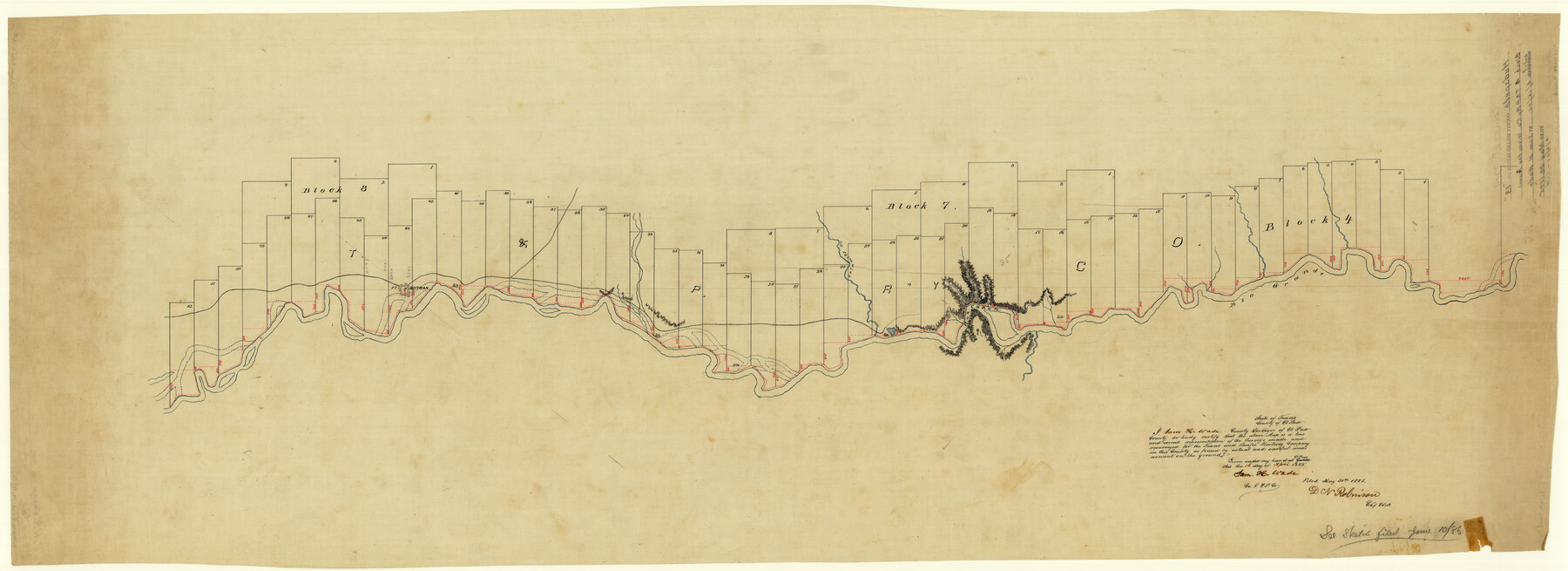
Hudspeth County Rolled Sketch 13
[Sketch of T. & P. Ry. Co. Block 4 along Rio Grande]
-
Map/Doc
9201
-
Collection
General Map Collection
-
Object Dates
1885/4/15 (Creation Date)
1885/5/30 (File Date)
-
People and Organizations
Sam H. Wade (Surveyor/Engineer)
-
Counties
Hudspeth
-
Subjects
Surveying Rolled Sketch
-
Height x Width
22.6 x 62.1 inches
57.4 x 157.7 cm
-
Medium
paper, manuscript
Part of: General Map Collection
[Surveys in Polk and Chambers Counties]
![355, [Surveys in Polk and Chambers Counties], General Map Collection](https://historictexasmaps.com/wmedia_w700/maps/355.tif.jpg)
Print $3.00
- Digital $50.00
[Surveys in Polk and Chambers Counties]
Size 11.7 x 14.4 inches
Map/Doc 355
Oyster Creek, Texas showing connection with Brazos River & Oyster Bay by the Galveston & Brazos Canal for a Light Draft Navigation

Print $40.00
- Digital $50.00
Oyster Creek, Texas showing connection with Brazos River & Oyster Bay by the Galveston & Brazos Canal for a Light Draft Navigation
Size 18.0 x 52.9 inches
Map/Doc 96562
Garza County Sketch File 2

Print $20.00
- Digital $50.00
Garza County Sketch File 2
Size 33.1 x 30.3 inches
Map/Doc 10462
Borden County Boundary File 5

Print $58.00
- Digital $50.00
Borden County Boundary File 5
Size 14.3 x 8.6 inches
Map/Doc 50650
Rains County Sketch File 2

Print $4.00
- Digital $50.00
Rains County Sketch File 2
Size 10.1 x 7.4 inches
Map/Doc 34945
[Sketch for Mineral Application 33721 - 33725 Incl. - Padre and Mustang Island]
![2879, [Sketch for Mineral Application 33721 - 33725 Incl. - Padre and Mustang Island], General Map Collection](https://historictexasmaps.com/wmedia_w700/maps/2879.tif.jpg)
Print $20.00
- Digital $50.00
[Sketch for Mineral Application 33721 - 33725 Incl. - Padre and Mustang Island]
1942
Size 29.4 x 22.2 inches
Map/Doc 2879
Young County Boundary File 98a

Print $32.00
- Digital $50.00
Young County Boundary File 98a
Size 10.2 x 8.0 inches
Map/Doc 60211
Flight Mission No. DAG-21K, Frame 36, Matagorda County

Print $20.00
- Digital $50.00
Flight Mission No. DAG-21K, Frame 36, Matagorda County
1952
Size 18.5 x 22.3 inches
Map/Doc 86403
Brewster County Rolled Sketch 55

Print $40.00
- Digital $50.00
Brewster County Rolled Sketch 55
1935
Size 24.2 x 58.8 inches
Map/Doc 5227
Sutton County Working Sketch 41

Print $20.00
- Digital $50.00
Sutton County Working Sketch 41
1950
Size 22.4 x 33.8 inches
Map/Doc 62384
Crockett County Working Sketch 3

Print $20.00
- Digital $50.00
Crockett County Working Sketch 3
Size 21.5 x 16.5 inches
Map/Doc 68336
Gulf of Mexico

Print $20.00
- Digital $50.00
Gulf of Mexico
1908
Size 18.4 x 27.0 inches
Map/Doc 72657
You may also like
Crockett County Rolled Sketch 29

Print $20.00
- Digital $50.00
Crockett County Rolled Sketch 29
1927
Size 21.9 x 36.6 inches
Map/Doc 5588
Crane County State of Texas

Print $20.00
- Digital $50.00
Crane County State of Texas
1889
Size 22.9 x 17.6 inches
Map/Doc 4524
Map of Sherman County

Print $20.00
- Digital $50.00
Map of Sherman County
1902
Size 40.9 x 36.6 inches
Map/Doc 16815
Brazos River, Brazos River Sheet 6

Print $4.00
- Digital $50.00
Brazos River, Brazos River Sheet 6
1926
Size 29.0 x 24.3 inches
Map/Doc 65299
"Iron Mountain Route" to all parts of Texas - I. & G. N., T. & P., Iron Mountain - "The Way to Texas"

Print $20.00
- Digital $50.00
"Iron Mountain Route" to all parts of Texas - I. & G. N., T. & P., Iron Mountain - "The Way to Texas"
1909
Size 22.0 x 24.0 inches
Map/Doc 95792

Frio County Working Sketch 20

Print $20.00
- Digital $50.00
Frio County Working Sketch 20
1985
Size 36.3 x 36.0 inches
Map/Doc 69294
General Highway Map, Andrews County, Gaines County, Texas

Print $20.00
General Highway Map, Andrews County, Gaines County, Texas
1940
Size 24.9 x 18.4 inches
Map/Doc 79002
Brazoria County Sketch File 11

Print $4.00
- Digital $50.00
Brazoria County Sketch File 11
Size 10.5 x 8.5 inches
Map/Doc 14965
Marion County Boundary File 61

Print $6.00
- Digital $50.00
Marion County Boundary File 61
Size 12.8 x 8.2 inches
Map/Doc 56816
Current Miscellaneous File 27

Print $4.00
- Digital $50.00
Current Miscellaneous File 27
1952
Size 10.8 x 8.3 inches
Map/Doc 73909
Reeves County Sketch File 6

Print $20.00
- Digital $50.00
Reeves County Sketch File 6
Size 17.3 x 28.3 inches
Map/Doc 12242