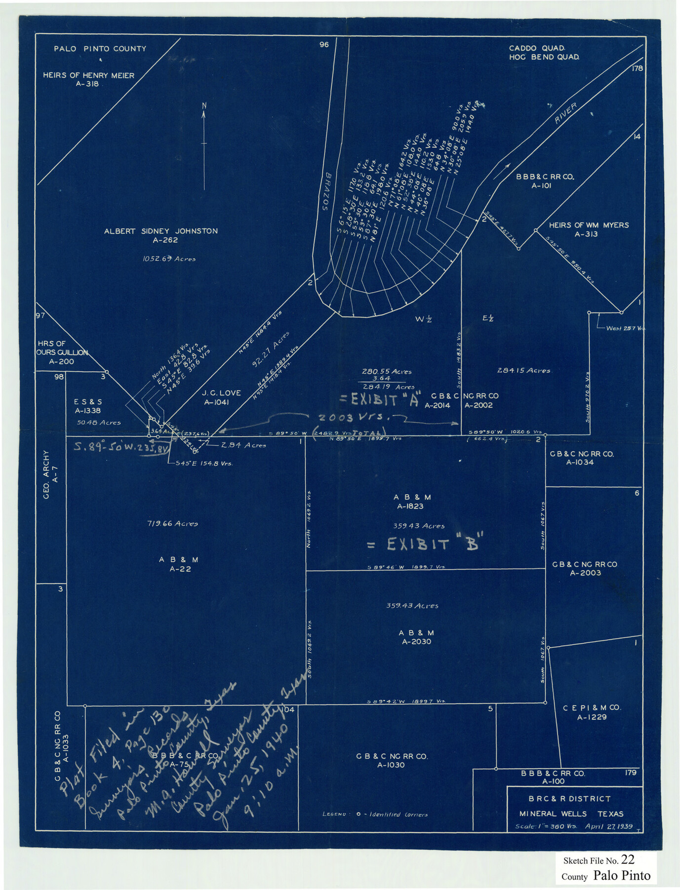
Palo Pinto County Sketch File 22
[NW Part of Palo Pinto County around the Boydstun survey]
-
Map/Doc
12134
-
Collection
General Map Collection
-
Object Dates
4/27/1939 (Creation Date)
1/25/1940 (File Date)
4/27/1939 (Survey Date)
-
People and Organizations
M.A. Howell (Surveyor/Engineer)
-
Counties
Palo Pinto
-
Subjects
Surveying Sketch File
-
Height x Width
19.6 x 15.0 inches
49.8 x 38.1 cm
-
Medium
blueprint/diazo
-
Scale
1" = 360 varas
-
Features
Brazos River
Part of: General Map Collection
Collin County Boundary File 1

Print $8.00
- Digital $50.00
Collin County Boundary File 1
Size 12.7 x 8.1 inches
Map/Doc 51678
Crane County Working Sketch 26

Print $20.00
- Digital $50.00
Crane County Working Sketch 26
1971
Size 32.4 x 33.0 inches
Map/Doc 68303
Brazoria County Working Sketch 14

Print $20.00
- Digital $50.00
Brazoria County Working Sketch 14
1940
Size 33.6 x 43.9 inches
Map/Doc 67499
Map of a part of the North Portion of Harris County

Print $40.00
- Digital $50.00
Map of a part of the North Portion of Harris County
Size 34.5 x 57.0 inches
Map/Doc 2049
Jack County Working Sketch 2

Print $20.00
- Digital $50.00
Jack County Working Sketch 2
1939
Size 10.9 x 17.7 inches
Map/Doc 66428
Webb County Sketch File B1

Print $20.00
- Digital $50.00
Webb County Sketch File B1
Size 16.9 x 26.4 inches
Map/Doc 12606
Coke County Rolled Sketch 19A

Print $20.00
- Digital $50.00
Coke County Rolled Sketch 19A
1954
Size 19.9 x 24.8 inches
Map/Doc 5520

Controlled Mosaic by Jack Amman Photogrammetric Engineers, Inc - Sheet 30

Print $20.00
- Digital $50.00
Controlled Mosaic by Jack Amman Photogrammetric Engineers, Inc - Sheet 30
1954
Size 20.0 x 24.0 inches
Map/Doc 83483
Flight Mission No. DIX-6P, Frame 181, Aransas County

Print $20.00
- Digital $50.00
Flight Mission No. DIX-6P, Frame 181, Aransas County
1956
Size 18.9 x 22.6 inches
Map/Doc 83843
Hamilton County Working Sketch 17

Print $20.00
- Digital $50.00
Hamilton County Working Sketch 17
1951
Size 44.4 x 25.0 inches
Map/Doc 63355
Kimble County Working Sketch 14

Print $20.00
- Digital $50.00
Kimble County Working Sketch 14
1923
Size 17.2 x 13.2 inches
Map/Doc 70082
You may also like
Grimes County Working Sketch 18

Print $20.00
- Digital $50.00
Grimes County Working Sketch 18
1990
Size 33.1 x 42.5 inches
Map/Doc 63309
Garza County Rolled Sketch 6

Print $53.00
- Digital $50.00
Garza County Rolled Sketch 6
Size 43.6 x 30.0 inches
Map/Doc 9052
Honey Grove, Tex., Fannin County, 1886

Print $20.00
Honey Grove, Tex., Fannin County, 1886
1886
Size 15.9 x 22.2 inches
Map/Doc 89091
San Patricio County Rolled Sketch 27

Print $40.00
- Digital $50.00
San Patricio County Rolled Sketch 27
Size 49.5 x 37.8 inches
Map/Doc 9890
Leon County Sketch File 30

Print $6.00
- Digital $50.00
Leon County Sketch File 30
1951
Size 11.2 x 8.7 inches
Map/Doc 29829
Cameron County NRC Article 33.136 Sketch 1

Print $3.00
- Digital $50.00
Cameron County NRC Article 33.136 Sketch 1
2001
Size 11.3 x 17.4 inches
Map/Doc 61558
No. 1 - Survey for a road from the Brazo Santiago to the Rio Grande

Print $20.00
- Digital $50.00
No. 1 - Survey for a road from the Brazo Santiago to the Rio Grande
1847
Size 18.3 x 27.0 inches
Map/Doc 72873
Montgomery County

Print $20.00
- Digital $50.00
Montgomery County
1901
Size 42.2 x 47.4 inches
Map/Doc 66939
Edwards County Working Sketch 30

Print $20.00
- Digital $50.00
Edwards County Working Sketch 30
1947
Size 27.7 x 38.2 inches
Map/Doc 68906
[Surveys in Power and Hewetson's Colony along the Aransas River, Middle Creek, Papalose Creek, and Blanco Creek]
![81, [Surveys in Power and Hewetson's Colony along the Aransas River, Middle Creek, Papalose Creek, and Blanco Creek], General Map Collection](https://historictexasmaps.com/wmedia_w700/maps/81.tif.jpg)
Print $20.00
- Digital $50.00
[Surveys in Power and Hewetson's Colony along the Aransas River, Middle Creek, Papalose Creek, and Blanco Creek]
1830
Size 21.6 x 21.2 inches
Map/Doc 81
Houston Ship Channel, Alexander Island to Carpenter Bayou

Print $20.00
- Digital $50.00
Houston Ship Channel, Alexander Island to Carpenter Bayou
1971
Size 34.9 x 46.0 inches
Map/Doc 69908
Brewster County Sketch File S-27

Print $10.00
- Digital $50.00
Brewster County Sketch File S-27
1966
Size 11.4 x 8.7 inches
Map/Doc 15841