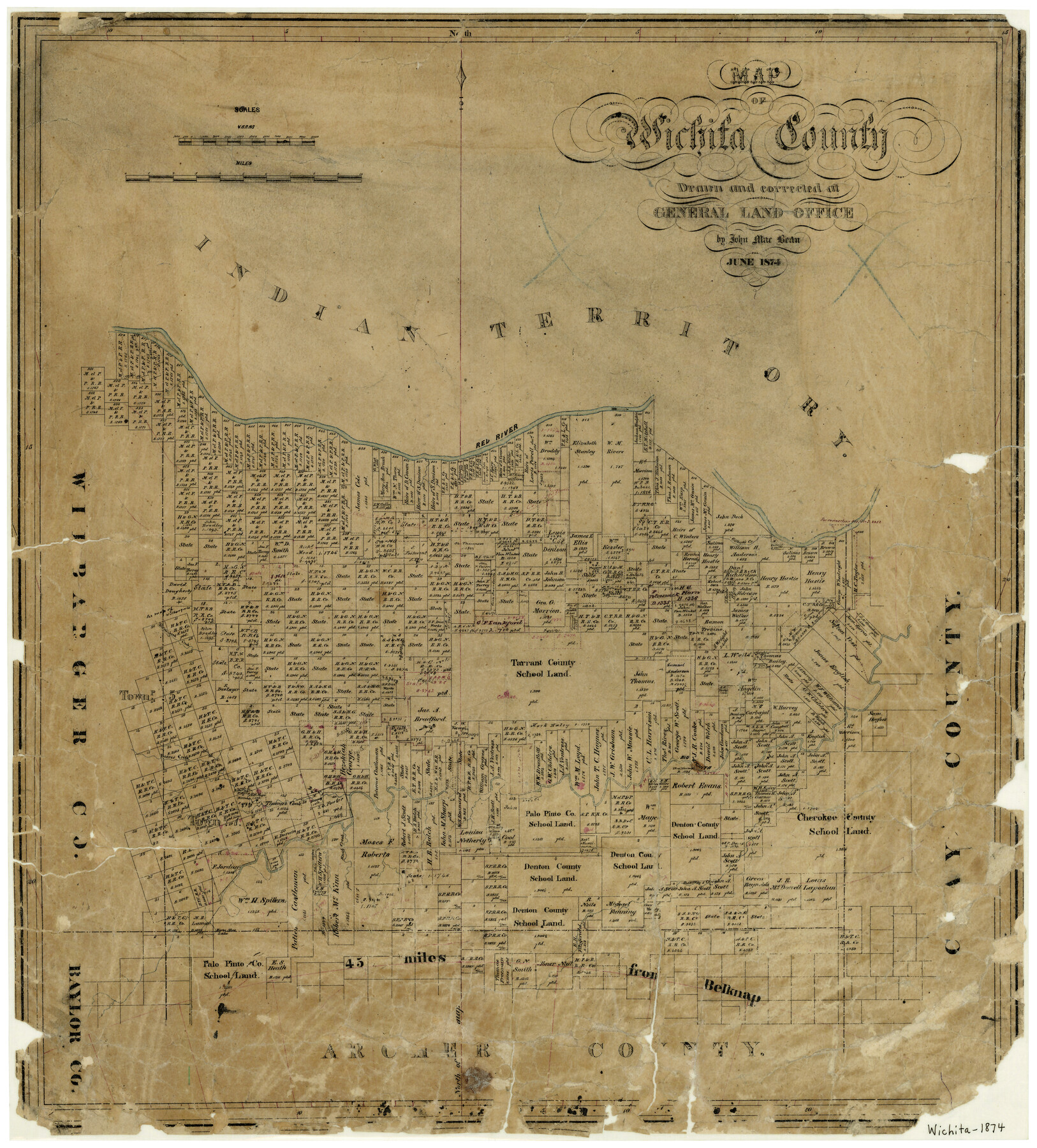
Map of Wichita County
-
Map/Doc
4142
-
Collection
General Map Collection
-
Object Dates
6/1874 (Creation Date)
-
People and Organizations
John Mac Bean (Draftsman)
-
Counties
Wichita
-
Subjects
County
-
Height x Width
22.8 x 21.0 inches
57.9 x 53.3 cm
-
Features
Red River
Gilbert's Creek
Buffalo Head Creek
Big Wichita River
Beaver Creek
Lee's Creek
Rush Creek
Horse Shoe Lake
Holliday Creek
Belknap Road
Part of: General Map Collection
Yoakum County Sketch File 19

Print $18.00
- Digital $50.00
Yoakum County Sketch File 19
1898
Size 11.5 x 8.8 inches
Map/Doc 40832
Van Zandt County Working Sketch 4

Print $20.00
- Digital $50.00
Van Zandt County Working Sketch 4
1929
Size 16.3 x 26.8 inches
Map/Doc 72253
Fisher County Working Sketch 2

Print $20.00
- Digital $50.00
Fisher County Working Sketch 2
1920
Size 23.0 x 18.2 inches
Map/Doc 69136
[Map showing resurvey of Capitol Leagues in Hartley & Oldham Counties, Texas]
![1754, [Map showing resurvey of Capitol Leagues in Hartley & Oldham Counties, Texas], General Map Collection](https://historictexasmaps.com/wmedia_w700/maps/1754-1.tif.jpg)
Print $20.00
- Digital $50.00
[Map showing resurvey of Capitol Leagues in Hartley & Oldham Counties, Texas]
1918
Size 30.8 x 37.4 inches
Map/Doc 1754
Padre Island, Register No. 1485a

Print $40.00
- Digital $50.00
Padre Island, Register No. 1485a
1881
Size 55.7 x 36.7 inches
Map/Doc 73609
Copy of Surveyor's Field Book, Morris Browning - In Blocks 7, 5 & 4, I&GNRRCo., Hutchinson and Carson Counties, Texas

Print $2.00
- Digital $50.00
Copy of Surveyor's Field Book, Morris Browning - In Blocks 7, 5 & 4, I&GNRRCo., Hutchinson and Carson Counties, Texas
1888
Size 6.9 x 8.8 inches
Map/Doc 62260
Armstrong County Sketch File 8

Print $8.00
- Digital $50.00
Armstrong County Sketch File 8
Size 14.2 x 8.8 inches
Map/Doc 13705
Calhoun County NRC Article 33.136 Sketch 11

Digital $50.00
Calhoun County NRC Article 33.136 Sketch 11
2023
Map/Doc 97255
[Sketch for Mineral Application 13436 - 13441]
![65581, [Sketch for Mineral Application 13436 - 13441], General Map Collection](https://historictexasmaps.com/wmedia_w700/maps/65581.tif.jpg)
Print $40.00
- Digital $50.00
[Sketch for Mineral Application 13436 - 13441]
1925
Size 56.8 x 42.4 inches
Map/Doc 65581
Webb County Sketch File 48

Print $20.00
- Digital $50.00
Webb County Sketch File 48
1939
Size 17.9 x 26.7 inches
Map/Doc 12646
La Salle County Working Sketch 56

Print $20.00
- Digital $50.00
La Salle County Working Sketch 56
2012
Size 25.5 x 23.0 inches
Map/Doc 93277
Edwards County Sketch File 16a

Print $24.00
- Digital $50.00
Edwards County Sketch File 16a
1903
Size 14.3 x 8.8 inches
Map/Doc 21720
You may also like
Survey of the Mexican Lines of Defence at Cerro Gordo, and the lines of attack of the American Army under Major General Scott, on the 17th and 18th of April, 1847

Print $20.00
- Digital $50.00
Survey of the Mexican Lines of Defence at Cerro Gordo, and the lines of attack of the American Army under Major General Scott, on the 17th and 18th of April, 1847
1847
Size 15.3 x 21.6 inches
Map/Doc 95830
Flight Mission No. CLL-1N, Frame 82, Willacy County

Print $20.00
- Digital $50.00
Flight Mission No. CLL-1N, Frame 82, Willacy County
1954
Size 18.3 x 22.1 inches
Map/Doc 87028
Jefferson County Rolled Sketch 61B

Print $20.00
- Digital $50.00
Jefferson County Rolled Sketch 61B
1928
Size 27.3 x 40.3 inches
Map/Doc 6411
Texas, Matagorda Bay, Matagorda Peninsula, Central Section

Print $20.00
- Digital $50.00
Texas, Matagorda Bay, Matagorda Peninsula, Central Section
1933
Size 28.3 x 42.7 inches
Map/Doc 69987
Motley County Boundary File 2e

Print $40.00
- Digital $50.00
Motley County Boundary File 2e
Size 29.4 x 96.1 inches
Map/Doc 57561
Right of Way & Track Map San Antonio & Aransas Pass Railway Co.

Print $40.00
- Digital $50.00
Right of Way & Track Map San Antonio & Aransas Pass Railway Co.
1919
Size 25.1 x 56.7 inches
Map/Doc 64026
General Highway Map, Lavaca County, Texas

Print $20.00
General Highway Map, Lavaca County, Texas
1940
Size 24.7 x 18.3 inches
Map/Doc 79170
Flight Mission No. DIX-10P, Frame 181, Aransas County

Print $20.00
- Digital $50.00
Flight Mission No. DIX-10P, Frame 181, Aransas County
1956
Size 18.5 x 22.2 inches
Map/Doc 83971
Atascosa County Sketch File 41

Print $8.00
- Digital $50.00
Atascosa County Sketch File 41
1956
Size 11.3 x 8.8 inches
Map/Doc 13837

Archer County Working Sketch 22

Print $20.00
- Digital $50.00
Archer County Working Sketch 22
1980
Size 36.4 x 38.0 inches
Map/Doc 67163
