Armstrong County Sketch File 8
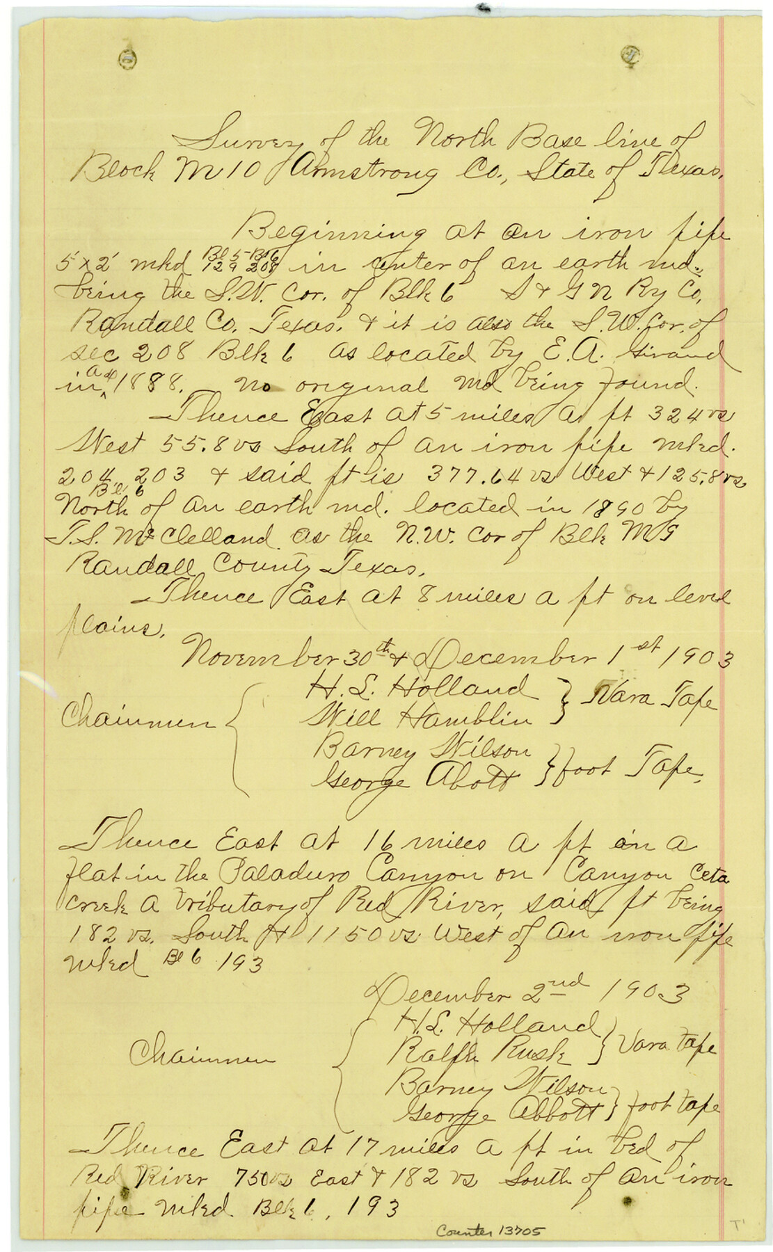
Survey of the north base line of Block M10
-
Map/Doc
13705
-
Collection
General Map Collection
-
Object Dates
1903/12/5 (Survey Date)
1904/1/18 (File Date)
1903/12/4 (Survey Date)
1903/12/2 (Survey Date)
1903/11/30 (Survey Date)
1903/12/1 (Survey Date)
-
People and Organizations
H.S. Holland (Chainman)
Will Hamblin (Chainman)
Barney Wilson (Chainman)
George Abbott (Chainman)
Ralph Rusk (Chainman)
John McGehee (Chainman)
M.L. McGehee (Chainman)
W.J. Woods (Surveyor/Engineer)
-
Counties
Armstrong Randall
-
Subjects
Surveying Sketch File
-
Height x Width
14.2 x 8.8 inches
36.1 x 22.4 cm
-
Medium
paper, manuscript
-
Features
Palo Duro Canyon
Ceta Creek
Red River
Part of: General Map Collection
Bee County Working Sketch 19

Print $20.00
- Digital $50.00
Bee County Working Sketch 19
1980
Size 17.3 x 11.9 inches
Map/Doc 67269
Wichita County Working Sketch 21

Print $20.00
- Digital $50.00
Wichita County Working Sketch 21
1951
Size 28.4 x 30.2 inches
Map/Doc 72531
Galveston County Sketch File 50

Print $70.00
- Digital $50.00
Galveston County Sketch File 50
Size 14.2 x 8.7 inches
Map/Doc 23481
Uvalde County Working Sketch 66

Print $20.00
- Digital $50.00
Uvalde County Working Sketch 66
1942
Size 20.9 x 21.3 inches
Map/Doc 75968
Van Zandt County Sketch File 16a

Print $4.00
- Digital $50.00
Van Zandt County Sketch File 16a
1858
Size 8.5 x 8.0 inches
Map/Doc 39412
Ward County Rolled Sketch 19

Print $20.00
- Digital $50.00
Ward County Rolled Sketch 19
1949
Size 20.5 x 26.7 inches
Map/Doc 8161
Stephens County Sketch File 13

Print $4.00
- Digital $50.00
Stephens County Sketch File 13
Size 11.2 x 8.8 inches
Map/Doc 37063
Nueces County Sketch File 55

Print $16.00
- Digital $50.00
Nueces County Sketch File 55
1999
Size 11.3 x 8.8 inches
Map/Doc 32867

Fort Bend County State Real Property Sketch 12

Print $40.00
- Digital $50.00
Fort Bend County State Real Property Sketch 12
1986
Size 43.2 x 35.0 inches
Map/Doc 61686
Hopkins County Sketch File 11

Print $4.00
- Digital $50.00
Hopkins County Sketch File 11
Size 7.7 x 7.7 inches
Map/Doc 26704
Duval County Rolled Sketch HD

Print $20.00
- Digital $50.00
Duval County Rolled Sketch HD
1939
Size 22.8 x 32.8 inches
Map/Doc 5767
You may also like
Archer County Rolled Sketch B2

Print $20.00
- Digital $50.00
Archer County Rolled Sketch B2
1891
Size 36.7 x 30.7 inches
Map/Doc 5105
Sutton County Sketch File JAC

Print $20.00
- Digital $50.00
Sutton County Sketch File JAC
Size 24.5 x 23.4 inches
Map/Doc 12398
Nueces County Rolled Sketch 92

Print $222.00
Nueces County Rolled Sketch 92
1983
Size 24.6 x 43.7 inches
Map/Doc 7028
Tyler County Working Sketch 3

Print $20.00
- Digital $50.00
Tyler County Working Sketch 3
1922
Size 28.0 x 32.6 inches
Map/Doc 69473
Map of Glasscock County

Print $20.00
- Digital $50.00
Map of Glasscock County
Size 18.9 x 23.1 inches
Map/Doc 90710

Cottle County Sketch File 7

Print $20.00
- Digital $50.00
Cottle County Sketch File 7
1893
Size 22.1 x 20.7 inches
Map/Doc 11191
Burnet County Sketch File 36

Print $60.00
- Digital $50.00
Burnet County Sketch File 36
1935
Size 25.7 x 17.6 inches
Map/Doc 11025
McMullen County, Texas

Print $20.00
- Digital $50.00
McMullen County, Texas
1889
Size 28.7 x 22.1 inches
Map/Doc 575
Cameron County Rolled Sketch 32

Print $40.00
- Digital $50.00
Cameron County Rolled Sketch 32
1981
Size 136.6 x 18.1 inches
Map/Doc 8579
Flight Mission No. BRE-2P, Frame 122, Nueces County

Print $20.00
- Digital $50.00
Flight Mission No. BRE-2P, Frame 122, Nueces County
1956
Size 18.4 x 22.4 inches
Map/Doc 86798
Flight Mission No. DAG-24K, Frame 124, Matagorda County

Print $20.00
- Digital $50.00
Flight Mission No. DAG-24K, Frame 124, Matagorda County
1953
Size 18.4 x 22.3 inches
Map/Doc 86542